Jalgaon district
| Jalgaon district जळगाव जिल्हा | |
|---|---|
| District of Maharashtra | |
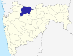 Location of Jalgaon district in Maharashtra | |
| Country | India |
| State | Maharashtra |
| Administrative division | Jalgaon Division |
| Headquarters | Jalgaon |
| Tehsils | 1. Jalgaon, 2. Jamner, 3. Chalisgaon, 4. Dharangaon, 5. Bhusawal, 6. Bodwad, 7. Yawal, 8. Raver, 9. Muktainagar, 10. Amalner, 11. Chopda, 12. Parola, 13. Pachora, 14. Erandol |
| Government | |
| • Lok Sabha constituencies | 1. Jalgaon, 2. Raver (shared with Buldhana District) (Based on Election Commission website) |
| • Assembly seats | 12 |
| Area | |
| • Total | 11,765 km2 (4,542 sq mi) |
| Population (2011) | |
| • Total | 4,224,442 |
| • Density | 360/km2 (930/sq mi) |
| • Urban | 70% |
| Demographics | |
| • Literacy | 85 |
| • Sex ratio | 933 |
| Major highways | NH-6 National Highway 211 (India) NH-211 |
| Average annual precipitation | 690 mm |
| Website | Official website |
-19849.jpg)
Jalgaon district is a district of Maharashtra, India. It was formerly known as East Khandesh district, prior to 21 October 1960, It has an area of 11,765 km²,and a population of 3,682,690 (2001 census) of which 71.4% were living in rural areaa.[1]
It is bounded by Madhya Pradesh state to the north, and by the districts of Buldhana to the east, Jalna to the southeast, Aurangabad to the south, Nashik to the southwest, and Dhule to the west.
Economy
Agriculture
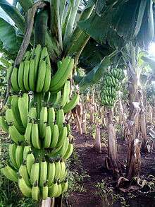
The major crops produced in this district are banana (In Maharashtra, Jalgaon ranks as number one in banana production and size, 32,000 hectares [2]), cotton, sorghum, wheat, millet, lime, groundnut and sugarcane.
Precipitation in Jalgaon
On average, the rainfall measured and recorded in Jalgaon is between the range of 77 cm and 80 cm. At the eastern side of district i.e. in Yawal Taluka the average recorded rainfall is 77 cm, while in Jalgaon, Bhusawal and Pachora it is 79 cm. In Jamner, the recorded average rainfall is 80 cm.[2]
History
The present territory of the district was part of the independent Khandesh Sulatanate ruled by the Faruqi dynasty from 1382-1601. It was previously part of Khandesh. According to Abul Fazal (Gladwin's Aine Akbari 1157), the name Khandesh is derived from the Khan title given by Ahmad-I of Gujarat (1411-1443) to Malik Nasir, the second of the Faruki kings. According to some sources, the name comes from the Khandava forest of Mahabharata.
The Mahabharata mentions Yuvanshava, the ruler of Toranmal (Nandurbar district) as fighting with the Pandavas. The rock temples and caves at Nashik and Ajanta show that during the first three centuries AD, Khandesh was under the rulers who supported Buddhism. Thereafter, it was ruled by Saptavananas, Andhrabhrityas, Virsen (Ahir King), Yawan dynasty, Chalukyas, Yadavas and then Alaud-din Khilji, Mohammad Tughlak, Malik Raja Malik Nazir, the Nizam of Hyderabad, and subsequently the Marathas ruled the region.
In the 18th century, Khandesh was captured by British troops from the Holkar regime using Dhule as the headquarters. The Hon. Robert Gill was the first officer of British East India Company in the Khandesh District with headquarters in Dhule.
In 1906 when Khandesh was divided, east Khandesh became present-day Jalgaon. In 1956 with the reorganisation of states, it was included in Bombay state, and with the formation of Maharashtra in 1960, Jalgaon became a district of the state.
In the Parola Tahsils, there are remains of a fort believed to belong to the father of the great Rani of Jhansi. An All India Congress Session of 1936 was held at Faizpur in Yawal Tehsil. In present times, legendary poet Bahinabai Chaudhari of Jalgaon spread the fame of the Ahirani dialect. Sane Guruji awakened the labour class while Balkavi Thomre's poetry enriched socio-cultural life of the district. In present-day the great farmer poet N. D. Mahanor has proved himself a golden quill in the crown of Jalgaon.
After annexation by Akbar in 1601, it became a part of Khandesh Subah of the Mughal empire. Subsequently, the region was ruled by the Nizam and the Marathas. In the early 18th century, Khandesh was captured by British troops from the Holkar ruler and a new district, Khandesh District was formed with its headquarters at Dhulia. Robert Gill was the first administrator of the British East India Company in Khandesh District. In 1906, when Khandesh district was bifurcated into two district, the present territory of Jalgaon district became East Khandesh district with its headquarters at Jalgaon. In 1956, after the reorganisation of the states, East Khandesh district was included in Bombay state and with the formation of Maharashtra state on May 1, 1960, East Khandesh district became a part of the state. It was renamed as Jalgaon district on October 21, 1960.[2]
Cooperative Sugar Factory (Sahakari Sakhar Kharkhana)
| Factory Name | Place | Taluka |
|---|---|---|
| Madhukar | Jivramnagar, Faizpur | Yawal |
| Belganga | Bhoras | Chalisgaon |
| Vasant | Kasoda | Erandol |
| Sant Muktai sugar & energy Ltd. | Ghodasgaon | Muktainagar |
| Copada Shetkari | Chopada | Chopada |
| Jamner Tauka | Gondkhel | Jamner |
| Vivek Patil | MIDC | JALGAON |
Source:[2]
Divisions
The district consists 15 talukas (tehsils). These are Jalgaon, Jamner, Erandol, Dharangaon, Bhusawal, Bodwad, Yawal, Raver, Muktainagar, Amalner, Chopda, Parola, Pachora, Chalisgaon and Bhadgaon. Jalgaon city is the administrative headquarters of this district.
Presently, there are 11 Vidhan Sabha (legislative assembly) constituencies in this district. These are : Chopda, Raver, Bhusawal, Jalgaon City, Jalgaon Rural, Amalner, Erandol, Chalisgaon, Pachora, Jamner and Muktainagar. Raver and Jalgaon are the two Lok Sabha constituencies in the district.[3]
There are 13 Nagar Parishad in district, which is the highest number of Nagar prishad in Maharashtra.[2]
River system in district
In Jalgaon Tapi(Surya-Putri;west flowing river) the river flows from the northernmost side. Its total length is 724 km and in Maharashtra its length is 208 km. The Girana river is also another long river in Jalgaon. The Gazetteer of the Bombay presidency describes the river as... "Rising in the western hills of the Kalvan sub-division of Nasik, and fed by streams from the northern slopes of the Chandor or Saptashring range, after a course of about 150 miles, falls into the Tapti near Nander. Its course lies in nearly equal parts in Nasik and Khandesh. Passing through Nasik almost in a straight line eastwards, in Khandesh its course changes to north-east, till, near Jalgaon, it bends north and then north-west flowing for several miles with many windings almost parallel to the Tapti. In Khandesh, except in one or two places where it is hemmed in by rocky hills, the Girna, over a broad sandy bed, flows through a well tilled valley gradually spreading into the great central plain. Its waters, both in Nasik and Khandesh, are used a lot for the purpose of irrigation. In Nasik lately repaired dams and channels water many of its upland valleys, and in Khandesh, from Eahal about ten miles north of Chalisgaon, the Jamda canals stretch east for about twenty-seven miles on the left and twelve miles on the right bank.
Tributary of Tapi river
On the right side of bank followong rivers meets Chandrabhaga, Bhuleshwari, Nand, Wan, Aner. On the left side of bank followong river meets Kapara, Sipana, Gadgi, Dolar, Pedhi, Katpurna, Morana, Man, Nalganga, Biswa.[2]
Demographics
According to the 2011 census Jalgaon district has a population of 4,224,442,[4] roughly equal to the Republic of the Congo[5] or the US state of Kentucky.[6] This gives it a ranking of 46th in India (out of a total of 640).[4] The district has a population density of 359 inhabitants per square kilometre (930/sq mi).[4] Its population growth rate over the decade 2001-2011 was 14.71%.[4] Jalgaon has a sex ratio of 922 females for every 1000 males,[4] and a literacy rate of 79.73%.[4]
Languages
The languages spoken in the Jalgaon district include Ahirani, a Kandeshi tongue with approximately 780 000 speakers, similar to Marathi and Bhili;[7] Bareli Palya, a Bhil language with approximately 10 000 speakers centred in Madhya Pradesh;[8] and Bareli Rathwi, another Bhil language with approximately 64 000 speakers, written in the Devanagari script and mutually unintelligible with Bareli Palya.[9]
Education
North Maharashtra University was established in Jalgaon on 15 August 1989. There are schools and colleges of Khandesh Education Society and Maratha Vidya Prasarak Mandal situated in the Jalgaon district as well.
Media
The major Marathi language newspapers published from the Jalgaon city are: Deshdoot, Deshonnati, Lokmat, Sakal, Divya Marathi,Maharashtra Times.
Notable personalities
- Bahinabai Chaudhari
- Sane Guruji
- Pratibha Patil
- Bhavarlalji Jain
- Eknath Khadse
- Ujjwal Nikam
- Vivek Patil
- Pramod Pardeshi
- Ghanshyam Patil
- Girish Mahajan
Places of interest around Jalgaon Dist.[10]
- Gandhi Teerth, Gandhi Foundation, Jalgaon
- Jain Research and Demonstration Center, Jain Hills, Jalgaon - For Farmers & Agriculture's
- Vekateshwar Temple, Jalgaon
- Omkareshwar Mandir - Jalgaon
- Echaa Devi Temple, Mehrun, Jalgaon
- Mehrun Lake, Mehrun, Jalgaon
- Sagar Park, Akashvani, Jalgaon
- Jain Temple, Dadawadi, Jalgaon
- Tarsod-Ganapati Temple, Tarsod, Jalgaon
- Unapdev Hot water ponds, Temples and hill station
- Padmalaya Kshetra - temples of Lord Ganapati and Hanuman in Erandol Taluka (4.8 km from Erandol) here ancient Indian mathematacian Aryabhatt wrote the book on mathematics "Lilavati"
- Bhim Kunda and Bhim's Mahadev Temple
- Swinging Towers Of Farkande, Erandol
- Maharshi kanva ashram, Kanalda
- Changdeo Maharaj temple in Changdev - Hatnur dam, confluence of Tapi river and Purna river,[11]
- Zugadevi temple near Bhusawal;
- Mangal grah Mandir,Amalner
- Gaureshwar Mahadev Temple to the PANJARA River border At-Shahapur Tal- Amalner
- Parola fort, Parola
- Shree Balaji - Parola
- Patnadevi temple in Chalisgaon
- Shitalnath Maharaj Mandir, Khadgaon, Goragawale bk Tal-chopda is located on the bank og river guli
- Sant Muktabai temple (Mehun temple) is located at a distance of 60–km from Jalgaon in MuktaiNagar city,
- Paal - Hill station
- Satpuda Manudevi Temple - Adgaon village in [[Yawal Taluka]
- Shree Jagatguru Ved Maharshi Vyas Muni Mandir-Yawal(Vyas Nagari)
- Munjoba Devsthan - Atrawal Tal Yawal
- Pavitra Tajuddin baba - hill station
- Prachin Nateshwar maharaj mandie
- Sati kamaladevi mandir
- Bhusawal - Thermal power plant
- Kannad taluka of Aurangabad district-Pitalkhora cave which is ancient cave in India.
- Ajanta Caves developed during the reign of Chalukya kingdom] are only 50 km from Jalgaon.
- Munjoba Devasthan is located in Waghod in Raver taluka. Phaijpur in Yawal taluka
- First session of Indian National Congress in 1936 by(PRESIDENT- Pandit Jawarlal Nehru)
- Utran- in Erandol taluka famous for high quality lemon. Lasur tal - Chopada
See also
References
- ↑
- 1 2 3 4 5 ISBN 938072559-0
- ↑ "District wise List of Assembly and Parliamentary Constituencies". Chief Electoral Officer, Maharashtra website.
- 1 2 3 4 5 6 "District Census 2011". Census2011.co.in. 2011. Retrieved 2011-09-30.
- ↑ US Directorate of Intelligence. "Country Comparison:Population". Retrieved 2011-10-01.
Congo, Republic of the 4,243,929
- ↑ "2010 Resident Population Data". U. S. Census Bureau. Retrieved 2011-09-30.
Kentucky 4,339,367
- ↑ M. Paul Lewis, ed. (2009). "Ahirani: A language of India". Ethnologue: Languages of the World (16th ed.). Dallas, Texas: SIL International. Retrieved 2011-09-28.
- ↑ M. Paul Lewis, ed. (2009). "Bareli, Palya: A language of India". Ethnologue: Languages of the World (16th ed.). Dallas, Texas: SIL International. Retrieved 2011-09-28.
- ↑ M. Paul Lewis, ed. (2009). "Bareli, Rathwi: A language of India". Ethnologue: Languages of the World (16th ed.). Dallas, Texas: SIL International. Retrieved 2011-09-28.
- ↑ http://jalgaon.nic.in/Html/Tourist_Information.htm
- ↑ Gopal Krishna Kanhere, The Temples of Maharashtra, Maharashtra Information Centre (from Government of Maharashtra), Mumbai, 2003, page 31-33
| Wikimedia Commons has media related to Minerals of Jalgaon District. |
 |
Barwani district, Madhya Pradesh | West Nimar district, Madhya Pradesh | Burhanpur district, Madhya Pradesh | |
| Dhule district | |
|||
| ||||
| | ||||
| Nashik district | Aurangabad district | Buldana district |
Coordinates: 18°39′0″N 75°6′0″E / 18.65000°N 75.10000°E
Jalgaon district topics | ||
|---|---|---|
| History | | |
| Tehsils | ||
| Education | ||
| Lok Sabha constituencies | ||
| Vidhan Sabha constituencies | ||
| Major towns and villages | ||
| Topics | |||||||||||||||||||||||
|---|---|---|---|---|---|---|---|---|---|---|---|---|---|---|---|---|---|---|---|---|---|---|---|
| Regions | |||||||||||||||||||||||
| Divisions and Districts |
| ||||||||||||||||||||||
| Million-plus cities in Maharashtra | |||||||||||||||||||||||
| Other cities with municipal corporations | |||||||||||||||||||||||
Portal: Maharashtra | |||||||||||||||||||||||