Marathwada
| Marathwada मराठवाडा | |
|---|---|
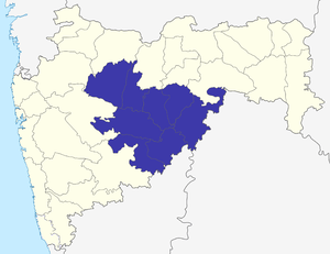 Location of Marathwada in Maharashtra | |
| Districts |
1. Aurangabad, 2. Nanded, 3. Latur, 4. Parbhani, 5. Jalna, 6. Beed, 7. Hingoli, 8. Osmanabad |
| Largest city's | Aurangabad,Parbhani |
| Divisions | Aurangabad division[1] |
| Area | 64,590 km2 (24,940 sq mi) |
| Population (2011) | 18,731,872[2] |
| Density (per km²) | 354[2] |
| Literacy | 76.27%[2] |
| Sex Ratio | 932[2] |
Marathwada (IPA:Marāṭhvāḍā) is one of the five regions in Indian state of Maharashtra. The region coincides with the Aurangabad Division of Maharashtra.
Etymology
The term Marathwada literally indicates "The House of Marathi people" that is land occupied by Marathi speaking population in former Hyderabad state in Nizam rule. 'Wada' in Marathi means House, so Maratha + Wada literally translates region of Marathi Speaking People. The origin of the term traced back to 18th century in state records of Nizam of Hyderabad.[3]
Historical highlights

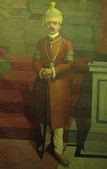

Mughal king Muhammad Shah appointed a Turani noble Asaf Jah I as the wazir of Mughal Empire in 1722, but in 1724 he left for the Deccan to start his own kingdom and took the title Nizam-ul-Mulk. Marathwada become a part of Nizam of Hyderabad, which later came to be known as the princely state of Hyderabad but under the suzerainty of British India. Mir Osman Ali Khan was the last Nizam ruler of Hyderabad state. ("Nizam" became the title of the ruling descendants of Nizam-ul-Mulk.)
On August 15, 1947, British India was partitioned into two independent states, the Union of India and Pakistan, and the Nizam ruling Hyderabad State at that time chose not to merge Hyderabad state into either country. Subsequently, through Operation Polo, a "police action" on September 17, 1948, the Indian army annexed Hyderabad to India.
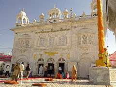
On November 1, 1956, Marathwada was transferred from Hyderabad State to Bombay State. On May 1, 1960, Bombay state was divided into Maharashtra and Gujarat states, Marathwada becoming a part of the former. Nanded and Aurangabad are the regional headquarters of Marathwada. Auranagabad, known as capital of Marathwada, derived its name from Mughal emperor Aurangzeb, who ruled it for a brief period. There is a demand to rename it as Sambhaji Nagar to honour the Marathi warrior Raje Sambhaji, son of The great Chhatrapati Shivaji Maharaj. Nanded is famous for the Sachkhand Gurudwara and one of the important city on the banks of river Godavari.
Demography
Marathwada has total area of 64590 km2, and has population of 18,731,872(2011 census).[4]
Districts
Marathwada includes following districts.
Within these eight districts, there are Municipal Corporations at Aurangabad,[5] Nanded,[6] Latur, and Parbhani.[7]
Major cities
Tourism
See also: Tourism in Marathwada

The state government recognises Aurangabad as the Tourism Capital of Maharashtra.[8] There are various tourist attractions in Aurangabad. Other places visited by tourists are:
- Ajanta caves
- Ellora caves
- Hazur Sahib Nanded
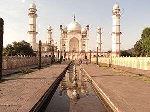
- Bibi Ka Maqbara
- Hazrat Turabul Haq Dargah at Parbhani
- Dharashiv Caves
- Aundha Nagnath
- Mahur
- Kandhar
- Deogiri fort / *Daulatabad
- Grishneshwar temple
- Parli
- Tuljapur
Education

.
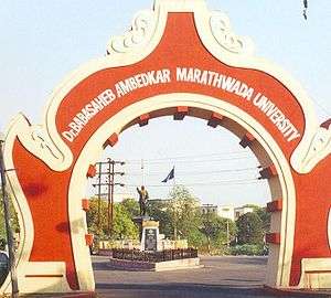
Marathwada has four government medical colleges, situated at Aurangabad, Latur, Nanded and Ambajogai. It also has three major universities, being Dr. Babasaheb Ambedkar Marathwada University at Aurangabad, Marathwada Agricultural University at Parbhani, and Swami Ramanand Teerth Marathwada University at Nanded.
Marathwada Statutory Development Board
Article 371(2) of Constitution of India is a special provision in respect of State of Maharashtra. According to this article, President of India can give special responsibility to Governor of Maharashtra to create separate development boards for Vidarbha, Marathwada, Rest of Maharashtra regions of Maharashtra. Marathwada Statutory Development Board releases annual report assessing problems within various districts of Marathwada, also monitors development work and expenditure.[9]
Major Findings of Annual Report
| Region | Small, Medium Industries(%) | Large Industries(%) | Per Capita Income(Rs) | Special Economic Zones | Foreign Direct Investment(%) |
|---|---|---|---|---|---|
| Marathwada | 07 | 11 | 60,013 | 10 | 02 |
| Vidarbha | 13 | 14 | 65,502 | 10 | 08 |
| Western Maharashtra | 80 | 75 | 105,488 | 96 | 90 |
- Annual Report 2011-12 shows some of striking findings of regional imbalance in Maharashtra.[9][10]
- Of total 'Micro, Small, Medium Enterprises' in Maharashtra, Marathwada has only 7% of enterprises while Vidarbha has 13%, Rest of Maharashtra has 80% of total enterprises.
- Of total 'Large Industries', Marathwada has 11%, Vidarbha 14% while Rest of Maharashtra has 75%.
- Per Capita Income of Marathwada is Rs.60013, Vidarbha Rs.65502, Rest of Maharashtra Rs.105488.
- Of total 116 Special Economic Zones of Maharashtra, Marathwada has 10, Vidarbha 10 and Rest of Maharashtra 96.
- Of total Foreign Direct Investment in Maharashtra, only 2% is in Marathwada while Vidarbha has 8% and Rest of Maharashtra has 90%.
Above findings shows that development of Maharashtra is concentrated in Western region that is Rest of Maharashtra while Marathwada region is least developed region in Maharashtra. Report also says that whatever development happened in Marathwada is concentrated around Aurangabad.[9][10]
Suicide of farmers
According to government records, 422 farmers in Marathwada committed suicide in 2014. This was because of their inability to bear crop losses and a financial quandary made acute by water scarcity and an agrarian crisis.[11] 2014 was the third consecutive year of low rainfall, and when rainfall did occur it was sometimes untimely and damaged crops. Of the 422 suicides, 252 cases were due to an inability to repay agricultural loans.[11]
Gallery
-

A view of Parli Vaijnath Temple, Beed District, one of 12 jyotirlingas of lord Shiva.
-
.jpg)
Famous Tulja Bhavani Temple of Tuljapur town of Osmanabad District.
-

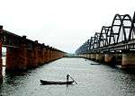
Jayakwadi Dam is one of main source of water for Marathwada.
-

Famous Holy Dargah Festival of Parbhani.
-
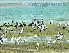
Migratory birds at Jayakwadi.
-

Grishneshwar Jyotirlinga in Aurangabad district.
-

Aundha Nagnath Jyotirlinga in Hingoli district.
-
.jpg)
Bibi Ka Maqbara inside view
-
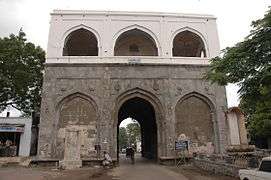
Bhadkal Gate built by Malik Ambar in commemoration of his victory against the Mughals.
-
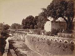
Panchakki, Baba Shah Mosafar Dargah 1880s Aurangababd.
-
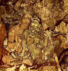
Painting from the Ajanta caves.
-

Kailasha temple at Ellora Caves.
-
.JPG)
Daulatabad Fort.
.JPG)

See also
- List of people from Marathwada
- Make in Maharashtra
- Manav Vikas Mission
- Maharashtra
- Sonesangavi
References
- ↑ ""Nanded division" carved out of "Aurangabad division".". The Times of India. 8 January 2015. Retrieved 24 May 2015.
- 1 2 3 4 "District wise Demography". Census 2011. Retrieved 23 May 2015.
- ↑ Kate, P.V. (1987). Marathwada under the Nizams, 1724-1948. Delhi, India: Mittal Publications. p. 3. ISBN 8170990173. Retrieved 12 July 2015.
- ↑ "Maharashtra Population Census data 2011". Government of India. Retrieved 11 April 2015.
Marathwada is not separate political or administrative entity so there is no reference of population by name of "Marathwada", population has been calculated by adding population of 8 districts of Marathwada.
- ↑ http://www.aurangabadmahapalika.org/singleIndex.jsp?orgid=95
- ↑ "NWCMC Home Page". Nwcmc.gov.in. Retrieved 2015-05-29.
- ↑ http://pcmcparbhani.org/
- ↑ "World News Headlines". Newkerala.com. Retrieved 2015-05-29.
- 1 2 3 "Marathwobada Statutory Development Board". Msdb.gov.in. Retrieved 2015-05-29.
- 1 2 http://msdb.gov.in/newsite/Annual%20Report%202011-12.pdf
- 1 2 "422 farmer suicides in 2014 in Marathwada gives BJP govt the jitters | Business Standard News". Business-standard.com. 2014-12-05. Retrieved 2015-05-29.
- Human Development Report 2002 - Maharashtra (India)
- History of Modern India, Bipin Chandra, Orient Blackswan, 2009
Further reading
- Marathwada under the Nizams (1724-1948) - P.V.Kate
- Beyond Economic Development: A Case Study of Marathwada
- Vidarbha and Marathwada: Trapped in a vicious cycle -Hindustan Times
- Cane cultivation leaving Marathwada bone dry: Study -The Times of India
- Photo-essay on the 2016 drought in Marathwada
- Have India's farm suicides really declined? -BBC article
- In worst drought year, Marathwada emerges new suicide region -Indian Express
- ‘Wrong method used to calculate Vidarbha, Marathwada backlog’ - The Times of India
- Lucien D. Benichou (1 January 2000). From Autocracy to Integration: Political Developments in Hyderabad State, 1938-1948. Orient Blackswan. ISBN 978-81-250-1847-6.
Largest city: Aurangabad Second largest: Nanded | |
| List of districts of Marathwada | |
| Cities with municipal corporations | |
| Topics | |
Portal: Maharashtra | |
| Topics | |||||||||||||||||||||||
|---|---|---|---|---|---|---|---|---|---|---|---|---|---|---|---|---|---|---|---|---|---|---|---|
| Regions | |||||||||||||||||||||||
| Divisions and Districts |
| ||||||||||||||||||||||
| Million-plus cities in Maharashtra | |||||||||||||||||||||||
| Other cities with municipal corporations | |||||||||||||||||||||||
Portal: Maharashtra | |||||||||||||||||||||||
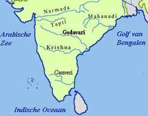
| Rivers |
|    | |||||||||||||||||||||||||
|---|---|---|---|---|---|---|---|---|---|---|---|---|---|---|---|---|---|---|---|---|---|---|---|---|---|---|---|
| Dams, barrages | |||||||||||||||||||||||||||
| Geographical features / regions | |||||||||||||||||||||||||||
| Riparian districts |
| ||||||||||||||||||||||||||
| Cities | |||||||||||||||||||||||||||
| Languages / people | |||||||||||||||||||||||||||
| Coalfields | |||||||||||||||||||||||||||
| Oil / gas fields | |||||||||||||||||||||||||||
| Industries |
| ||||||||||||||||||||||||||
| Transport | |||||||||||||||||||||||||||
| Related topics | |||||||||||||||||||||||||||
| Other basins | |||||||||||||||||||||||||||
Coordinates: 19°53′00″N 75°20′00″E / 19.8833°N 75.3333°E