Joypurhat District
| Joypurhat জয়পুরহাট | |
|---|---|
| District | |
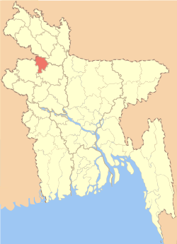 Location of Joypurhat in Bangladesh | |
| Coordinates: 25°06′N 89°02′E / 25.10°N 89.03°ECoordinates: 25°06′N 89°02′E / 25.10°N 89.03°E | |
| Country |
|
| Division | Rajshahi Division |
| Established | February 26, 1984 |
| Area | |
| • Total | 965.4 km2 (372.7 sq mi) |
| Population (2011 census)[1] | |
| • Total | 913,768 |
| • Density | 950/km2 (2,500/sq mi) |
| Demonym(s) | Bangladeshi |
| Time zone | BST (UTC+6) |
| Postal code | 5900 |
Joypurhat (Bengali: জয়পুরহাট জেলা,[ˈbangla] Joypurhat Jela also Joypurhat Zila) is a district in the northern part of Bangladesh. It is part of Rajshahi Division.[2]
History
Ancient history
Joypurhat was an area of Pala Empire & Sena dynasty from a long age. Till 16th and 17th centuries, there was no clear info about Joypurhat. In old age 'Baghabarihat(Bengali-বাঘাবাড়ীহাট)' was the local name of Joypurhat and Later 'Gopendraganjahat (Bengali-গোপেন্দ্রগঞ্জহাট)' was used in many archives. Once 'Lalbazar Thana(Bengali-লালবাজার থানা)' was established by containing the present Joypurhat Sadar Upazila and Panchbibi Upazila. The thana (upazila/sub-district) was located at east side of Small Jamuna River named 'Puranapoil (Bengali: পুরানাপৈল)'. Then Puranapoil Union was known as 'Karimanagar(Bengali: করিমনগর)'. Post office was established in Lalbazar Thana. The sub-registry office was in 'Nawabganj(Bengali: নবাবগঞ্জ)' named place, east side of Akkelpur Railway Station. There were many 'NeelKuthi(নীলকুঠি)' established in this area. At that era Lalbazar Thana was a town. Then that was the only one work place of ordinary people for their livelihood. From Lalbazar Thana, Small Jamuna River gorge, the whole travel, commerce and trade were maintained. At that period Lalbazar Thana, Khetlal Upazila & Badalgachhi Upazila were contained by Dinajpur District. For being big size of Dinajpur District, Rangpur District & Rajshahi District a new district came out named Bogra District from the three districts. It was declared 1821. At that time Bogra District occupied by Adamdighi, Bogra Sadar, Sherpur from Rajshahi District; two upazila from Rangpur District and Khetlal Upazila, Badalgachhi Upazila, Lalbazar Thana from Dinajpur. Later in December 16, 1868, Lalbazar Police Thana was moved in 'Khasbaguri(Bengali: খাসবাগুড়ী)'. The local name of Khasbabri was Panchbibi. In 1884, from Kolkata District to Jalpaiguri District in British Raj the rail way line established. Among this rail way line 8 railway station was built in the present Joypurhat District. In that time 'Baghabari(Bengali: বাঘাবাড়ী)' was the local name of Joypurhat and Baghabari Railway Station was the name of Joypurhat Railway Station. After establishing the railway station the people gathered more in railway beside area more than the river beside area of Small Jamuna River. People in the surrounding villages of railway have increased gradually settled. Gradually the 'Khanjanapur (Bengali: খঞ্জনপুর)' and 'Lalbazar Hat (Bengali: লালবাজার হাট)' goes extinct. Baghabari Hat became famous. After Being popular area, the name of 'Baghabari Railway Station' was replaced by the name Joypurhat Railway Station. And from that the whole area are known to Joypurhat to all.
Some says that, Joypurhat was renamed from the name of Pala Empire King JoyPal who ruled here in his period.
Geography
Rivers
Bangladesh is a country of many rivers. There are 5 rivers in Joypurhat District.
- Small Jamuna River; passes through Joypurhat Sadar Upazila and Panchbibi Upazila
- Tulshiganga River; passes through Joypurhat Sadar Upazila, Khetlal Upazila and Akkelpur Upazila
- Chiri River; passes through Panchbibi Upazila
- Haraboti River; passes through Panchbibi Upazila
- Sree River; passes through Chakbarkat Joypurhat Sadar Upazila
Climate
Joypurhat is a district of Tropical climate. In Winter there is much more rainfall in Joypurhat than in Summer. According to The Köppen climate classification, The average annual temperature in here is 25.4 °C and The average annual rainfall is 1738 mm. The driest month is December with 3 mm. Most Precipitation falls in July, with an average of 364 mm. The warmest month of the year is August with an average temperature of 28.9 °C. In January, the average Temperature is 18 °C. It is the lowest average temperature of the whole year.
| Climate data for Joypurhat | |||||||||||||
|---|---|---|---|---|---|---|---|---|---|---|---|---|---|
| Month | Jan | Feb | Mar | Apr | May | Jun | Jul | Aug | Sep | Oct | Nov | Dec | Year |
| Average high °C (°F) | 24.8 (76.6) |
27.6 (81.7) |
32.5 (90.5) |
35 (95) |
33.6 (92.5) |
32.4 (90.3) |
31.7 (89.1) |
31.6 (88.9) |
31.7 (89.1) |
31.1 (88) |
28.7 (83.7) |
25.9 (78.6) |
30.55 (87) |
| Daily mean °C (°F) | 18 (64) |
20.2 (68.4) |
24.9 (76.8) |
28.4 (83.1) |
28.7 (83.7) |
28.9 (84) |
28.9 (84) |
28.9 (84) |
28.6 (83.5) |
27 (81) |
22.8 (73) |
19.3 (66.7) |
25.38 (77.68) |
| Average low °C (°F) | 11.2 (52.2) |
12.9 (55.2) |
17.3 (63.1) |
21.9 (71.4) |
23.8 (74.8) |
25.4 (77.7) |
26.1 (79) |
26.2 (79.2) |
25.6 (78.1) |
22.9 (73.2) |
17 (63) |
12.6 (54.7) |
20.24 (68.47) |
| Average precipitation mm (inches) | 10 (0.39) |
15 (0.59) |
21 (0.83) |
52 (2.05) |
186 (7.32) |
330 (12.99) |
364 (14.33) |
321 (12.64) |
283 (11.14) |
140 (5.51) |
13 (0.51) |
3 (0.12) |
1,738 (68.42) |
| Source: National newspapers | |||||||||||||
The difference in Precipitation between the driest month and the wettest month is 361 mm. The average Temperatures vary during the year by 10.9 °C.
Economy
Joypurhat is called the store-house of food of Bangldesh. Joypurhat is famous & top in Bangladesh for production of all the agricultural products. Joypurhat's economy is mainly based on seasonal crops & fruits like Rice, Potato, Wheat, Onions, Mango, Jackfruits, Banana etc. It also produces a huge amount of sugarcane and it holds the country's largest sugar mill, Joypurhat Sugar Mill's Limited. There are also a lot of Industry, Rice mill & Poultry farm in this district. It export about all kinds of agricultural products every day. Hili land port is very close to Joypurhat district, so many people of this district do export-import business by this port & about all the vehicles of this port run over this district. This district is appropriate for all kind of Business.
Arts and culture
Joypurhat is a district of rural or rich folk culture. In British Raj period, many festivals such as keerton(কীর্তন), jaree(জারী), palagaan(পালাগান), kabigaan(কবিগান), baul(বাউল), murshidee(মুর্শিদী), lokgeeti(লোকগীতি), bhaoyaiya(ভাওয়াইয়া), jattra(যাত্রা) etc. was held on various occasion. The district bhaoyaiya song expose. These festivals was sponsored by the wealthy and overload men. After 1971, many cultural organizations established in this district level and upazila level. Now-a-days even the different obstacles and constraints, the Cultural Activities is running well.
Cultural group
- Joypurhat Shilpakala Academy (জয়পুরহাট শিল্প কলা একাডেমী)
- Joypurhat Shishu Academy (জয়পুরহাট শিশু একাডেমী)
- Conference of the National Council of Rabindra Sangeet (জাতীয় রবীন্দ্র সঙ্গীত সম্মেলন পরিষদ)
- Baul Cultural Organization (বাউল সাংস্কৃতিক সংগঠন)
- Joypurhat Music Cycle (জয়পুরহাট সঙ্গীত চক্র)
- Saragama Cultural Organization (সারগাম সাংস্কৃতিক সংগঠন)
- Samitma Theatre and Music Schools (শামিত্ম থিয়েটার ও সঙ্গীত বিদ্যালয়)
- Joypurhat Library and Club (জয়পুরহাট লাইব্রেরী এন্ড ক্লাব)
- Joypurhat Theatre (জয়পুরহাট থিয়েটার)
- Loko Songskriti Porishod
Points of interest
Jamalganj is situated 10 km(approx)south west of Jaipurhat. And Pahar Pur(Buddhist Bihar), largely known as Somepur Bihar, is situated just 6 km(approx)north-west of Jamalganj which is symbol of our past legacy of our knowledge on philosophy, architecture, arts and sculptures. Thousands of tourist visit from everywhere in the world. Jamalganj is mainly famous for its long traditional bazaar (in English market) fore surrounded places. It's very famous for agricultural products like banana, paddy, rice, wheat, potato and many more. Also famous for its mine like coal (bituminous) and cement. Another beautiful place of Joypurhat are – Abul Quashem Field in Sadar. Achhranga Beel (Khetlal upazila). Ashranga Lake. Baro Shibmondir. Ber Amla Bershibaloy. Bastob Puri. Cement Factory. Central Shahid Minar. English Marke . Gopinathpur Temple at Gupinathpur, Akkelpur. Graveyard of Mukshid Gazi. Hinda-Koshba Shahi Mosque at Khetlal. Khanjanpur Christian Mission (Joypurhat Sadar). Khasmohol Bhaban. Joypurhat Girls Cadette College. Joypurhat Sugar mills Ltd. Joypal Rajar Rajbari . Lokma Jomidar Bari, Pachbibi. Nandail Lake. Patharghata Church at Panchbib upazila . Pitarer Banglo. Pachbibir Mazar. Pagla Dewan Mass Graveyard. Somepur Bihar, is situated just 6 km(approx)north-west of Jamalganj. Shrine of Pathorghata. Shisu Uddyan.
Administration
Sub-districts

Joypurhat has 5 subdistricts (upazillas):[2]
| upazila | Bengali | url link | area (km²) | population |
|---|---|---|---|---|
| Joypurhat | জয়পুরহাট সদর উপজেলা | Official website | 238.5 | 256,691 |
| Akkelpur | আক্কেলপুর উপজেলা | Official website | 139.47 | 128,952 |
| Kalai | কালাই উপজেলা | Official website | 166.30 | 129,329 |
| Khetlal | ক্ষেতলাল উপজেলা | Official website | 142.60 | 115,871 |
| Panchbibi | পাঁচবিবি উপজেলা | Official website | 278.53 | 240,979 |
Municipalities
There are 3 municipalities in Joypurhat District.
Deputy Commissioner (DC): Mohammad Yasin (Bengali- মোহাম্মদ ইয়াছিন)
[3]
Mayor : MD Abdul Aziz Mollah (Bengali- মোঃ আব্দুল আজিজ মোল্লা)
[4]
Parliamentary seats
Joypurhat has two parliament seats. Joypurhat-1 & Joypurhat-2
| Constituency NO. | Constituency Name | Extent | Present Jatiyo Sangshad MP | In Bengali | Political Party | Legislature | Election Occupied |
|---|---|---|---|---|---|---|---|
| Joypurhat-1 |
|
|
|
Bangladesh Awami League | 10th Parliament | January 5, 2014 | |
| Joypurhat-2 |
|
|
|
Bangladesh Awami League | 10th Parliament | January 5, 2014 |
Transport
Roads
Joypurhat is a small district in Rajshahi Division. It has 342.59 km cobbled road, 61.59 km semi-cobbled road and 1569 km raw road.
Railway stations
Joypurhat contains 8 railway stations. The total Railway of joypurhat is 38.86 km.
- Joypurhat Railway Station, Joypurhat Sadar Upazila
- Panchbibi Railway Station, Panchbibi Upazila
- Jamalganj Railway Station, Akkelpur Upazila
- Akkelpur Railway Station, Akkelpur Upazila
- Jafarpur Railway Station, Akkelpur Upazila
- Tilakpur Railway Station, Akkelpur Upazila
- Puranapail Railway Station, Joypurhat Sadar Upazila
- Bagjana Railway Station, Panchbibi Upazila
Joypurhat Railway Station was established in 1884 in British Raj period. It is a very important Railway Station in the northern part of Bangladesh.
Education
The Second Girls Cadet College of Bangladesh is situated in Joypurhat since 2005 named Joypurhat Girls Cadet College. R.B. Govt. High School is a reputed high school in Joypurhat.
In Joypurhat District: tribal population account for approx. 2.25% of the population. Ethnic nationals: Santal, Orao, Munda, Mahali (Mahle), Koch, Pahan, Buna, Ho, Mahato, Rajbangshi etc. are noted tribes. Total tribal population: 48,000 (2001).com
Religion
The district of Joypurhat has 2573 mosques, 186 mosque-based library, 675 trained Imam, 2200 Imam, 424 temples, 21 churches and 18 Buddhist temples. Hinda - Kasba Shahi Mosque is one of the beautiful mosque in Joypurhat.
Literature
Joypurhat is a district of ancient civilization and culture organizations. In the time period of old and mid era, 'Joypurhat' contained knowledge ruled and Gauri(গৌরী) literature. Bengali literature poet Jayadeva Goswami (জয়দেব গোস্বামী) is the piece child of Joypurhat.
Literature and notable
| person | in Bengali | birthplace | notable | time period |
|---|---|---|---|---|
| Poet Jayadeva Goswami | কবি জয়দেব গোস্বামী | Kendoil village, Joypurhat Sadar Upazila | Geeti Gabinda Grontho (গীতি গবিন্দ গ্রন্থ) | In the time period of King Lakshman Sen |
| Poet Arif Saha | কবি আরিফ সাহা | Kuzail karimpur, Khetlal Upazila | Jingle tripadi(ত্রিপদী ছন্দ) | 2nd decade of 20th century |
| Jashim Uddin munshi | জসীম উদ্দীন মুন্সী | Vadsha, Joypurhat Sadar Upazila | Islam Missionary, Nachihate phucchaka(নছিহতে ফুচ্ছাক) | British Raj |
| Poet Sarker | কবি সরকার | Khetlal Upazila | Badal Mandal Manuscripts(বাদল মন্ডল পুথি) | 19th century |
In modern era Joypurhat contains many poets. Among them poet-litterateur:
- Ataur Rahman(আতাউর রহমান) – Nazrul Criticism Book(নজরুল সমালোচনা)
- Dr. Jahangir Chowdhury(ডঃ জাহাঙ্গীর চৌধুরী) – Modern Koryar Poem(আধুনিক কোরয়ার কবিতা)
- Abbas Ali Khan(আববাছ আলী খান) – Smritir Sagore Dheu(স্মৃতির সাগরে ঢেউ)
- Mohasin Ali Dewan(মহসীন আলী দেওয়ান)
- Sahadat Hossain(সাহাদৎ হোসাইন)
- Mozahar Hossain Jamalee(মোজাহার হোসেন জামালী) – Jeebon Nadir Bake Bake(জীবন নদীর বাঁকে বাঁকে)
- S.M. Ansar Ali(এস এম আনছার আলী) – Je Agun Nive Na(যে আগুন নিভলোনা)
- Playwright MD Alauddin(নাট্যকার মোঃ আলাউদ্দিন)
- Rezaul Karim(রেজাউল করিম) – Porajito Shaliker Anusochona(পরাজিত শালিকের অনুশোচনা)
- Sachindranath Barman(শচীন্দ্রনাথ বর্মন)
- Tahura Begum(তহুরা বেগম)
- Sayed Emdad Ali Dewan(সৈয়দ এমদাদ আলী দেওয়ান)
- Abdus Chattar(আবদুস ছাত্তার)
- Doctor Abu Haidar Sazedur Rahman ( Kuasha, Nayagra etc. )
- Azizul Hauqe Biswas ( Obbacto Dristi )
- Jaton Kumar Devnath ( Schorar Ghora )
- Najrul Isalm ( Jiboner Bornomala )
- Aminul Haque Babul ( Pothe Jete jete )
- Kobita Pervin ( Nisha Bai )
- Shahana Bithi ( Door Subas )
- Mojammel Hossen ( Shuktara )
- Roushon Ara Pervin ( Ghass Foring-er-Beye )
- Abdus Sattar Mridha, akkelpur ( Onuswar Bisorgo Chondrabindu )
- Mohammad Ali Masum ( protarona )
See also
References
| Wikimedia Commons has media related to Joypurhat District. |
- ↑ GeoHive
- 1 2 Md Azizul Haq (2012). "Joypurhat District". In Sirajul Islam and Ahmed A. Jamal. Banglapedia: National Encyclopedia of Bangladesh (Second ed.). Asiatic Society of Bangladesh.
- ↑ "01 Joypurhat DC". Retrieved January 8, 2014.
- ↑ "02 Joypurhat Mayor". Retrieved January 8, 2014.
External links

| Barisal Division |  | |
|---|---|---|
| Chittagong Division | ||
| Dhaka Division | ||
| Khulna Division | ||
| Mymensingh Division | ||
| Rajshahi Division | ||
| Rangpur Division | ||
| Sylhet Division | ||
Headquarters: Rajshahi | ||
| Bogra District | 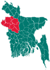 | |
| Joypurhat District | ||
| Naogaon District | ||
| Natore District | ||
| Nawabganj District | ||
| Pabna District | ||
| Rajshahi District | ||
| Sirajganj District | ||