Warangal Urban district
| Warangal Urban district వరంగల్ అర్బన్ జిల్లా وارنگل شہری ضِلع | |
|---|---|
| District of Telangana | |
| Country | India |
| State | Telangana |
| Tehsils | 11 |
| Government | |
| • District collector | Amrapalli Kata |
| Area | |
| • Total | 1,304.50 km2 (503.67 sq mi) |
| Population (2011) | |
| • Total | 1,135,707 |
| • Density | 870/km2 (2,300/sq mi) |
| Vehicle registration | TS–3[1][2] |
| Website | Official website |
_Revenue_division.png)
Warangal (urban) district is located in the northern region of the Indian state of Telangana. The district headquarters are located at Warangal.[3]
History
Warangal district consists of many Prehistoric habitation sites, which were explored by the Indian Archaeological authorities.
Paleolithic Rock art paintings are found at Pandavula gutta[4]
Padmakshi Gutta consists of a Jain temple dedicated to Goddess Padmavati, located on a hilltop in the heart of the town of Hanamkonda, was originally constructed during Kakatiya reign. Till the Kakatiya Kings renovated and established the Goddess Padmakshi, previously it was a ‘Basadi’ a Jain temple.[5] The temple also has rich sculpture of the Jain Tirthankara's and other Jain Gods and Goddesses. The Kadalalaya basadi or Padmakshi Temple is built on a large rocky out crop.
Angadi Veerannagudi a Jain temple located at Biranpally[4] village in Maddur Mandal in the district.
Kakatiya Reign
Warangal was the capital of Kakatiya Kingdom ruled by the Kakatiya dynasty from 12th to the 14th centuries. Warangal was also known as Orugallu. Oru means one and Kallu means stone. The entire city was carved out of a single rock, hence the name Orukallu (Ekasila Nagaram in Sanskrit). The Kakatiyas left many monuments, including impressive fortress, four massive stone gateways, the Swayambhu temple dedicated to Shiva, and the Ramappa temple situated near Ramappa Lake. The cultural and administrative distinction of the Kakatiyas was mentioned by the famous traveller Marco Polo. Prominent rulers included Ganapathi Deva, Prathapa Rudra, and Rudrama Devi. After the defeat of PratapaRudra, the Musunuri Nayaks united seventy two Nayak chieftains and captured Warangal from Delhi sultanate and ruled for fifty years. Jealousy and mutual rivalry between Nayaks ultimately led to the downfall of Hindus in 1370 A.D. and success of Bahmanis.
Nizam dynasty
Bahmani Sultanate later broke up into several smaller sultanates, of which the Golconda sultanate ruled Warangal. The Mughal emperor Aurangzeb conquered Golconda in 1687, and it remained part of the Mughal empire until the southern provinces of the empire split away to become the state of Hyderabad in 1724 which included the Telangana region and some parts of Maharashtra and Karnataka. Hyderabad became an Indian statein 1948. In 1956 Hyderabad was partitioned as part of the States Reorganisation Act, and Telangana, the Telugu-speaking region of Hyderabad state which includes Warangal, became part of Andhra Pradesh. After the bifurcation of the state of Andhra Pradesh, the district became a part of Telangana.
Geography
Warangal district occupies an area of 1,304.50 square kilometres (503.67 sq mi).[6]
Demographics
As of 2011 Census of India, the district has a population of 1,135,707.[6]
Administrative divisions
The district has only one revenue division of Warangal and is sub-divided into 11 mandals.[6] Amrapalli Kata is the present collector of the district.[7]
Mandals
| S.No. | Warangal revenue division |
|---|---|
| 1 | Bheemadevarpalli |
| 2 | Dharmasagar |
| 3 | Elkathurthy |
| 4 | Inavole |
| 5 | Hanamkonda |
| 6 | Hasanparthy |
| 7 | Kamalapur |
| 8 | Kazipet |
| 9 | Khila Warangal |
| 10 | Velair |
| 11 | Warangal |
Economy
In 2006 the Indian government named Warangal one of the country's 250 most backward districts (out of a total of 640).[8] It is one of the thirteen districts in Andhra Pradesh currently receiving funds from the Backward Regions Grant Fund Programme (BRGF).[8]
Culture

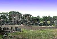
In February 2013, Warangal was accorded World Heritage town status by UNESCO.[9] A few tourist attractions include:
Some of the people from the district are, Rudrama Devi, Kaloji Narayana Rao and P. V. Narasimha Rao.
Transport
National Highway 163 (India) between Hyderabad – Bhopalpatnam of Chhattisgarh, passes through the district. Warangal has two railway stations Kazipet Railway Station and Warangal Railway Station, which connects South and North India. The district has a small airport in Mamnoor, which can accommodate small aircraft like the ATR 42. This airport is currently used by police for gliding sorties, skeet shooting and aero-modeling.[10]
Education
The schools in the district are under the administration of a District Education Officer controlled by Department of Education.[11] Kashinath is the present Intermediate education officer, who oversees the junior colleges in the district for Telangana Board of Intermediate Education.[12]
Some of the major educational institutions include, National Institute of Technology, Kakatiya Medical College, Kakatiya University, Kaloji Narayana Rao University of Health Sciences, University Arts and Science College, Kakatiya Institute of Technology and Science
See also
References
- ↑ http://www.sakshipost.com/telangana/2016/10/13/vehicle-registration-codes-for-new-districts-in-telangana
- ↑ "Vehicle Registration Codes For New Districts In Telangana". Sakshipost. Retrieved 13 October 2016.
- ↑ "Warangal (rural) district" (PDF). New Districts Formation Portal. Retrieved 11 October 2016.
- 1 2 http://www.aparchaeologymuseum.com/wp-content/uploads/2012/05/Warangal-dt.pdf
- ↑ "Category:Padmakshi Gutta". wikimedia.org.
- 1 2 3 "New districts". Andhra Jyothy.com. 8 October 2016. Retrieved 8 October 2016.
- ↑ "K Chandrasekhar Rao appoints collectors for new districts". Deccan Chronicle. 11 October 2016. Retrieved 13 October 2016.
- 1 2 Ministry of Panchayati Raj (8 September 2009). "A Note on the Backward Regions Grant Fund Programme" (PDF). National Institute of Rural Development. Retrieved 27 September 2011.
- ↑ "TV9 – Warangal accorded World Heritage town status by UNESCO – Telugu TVTelugu TV". Telugutv.au.com. 2013-02-28. Retrieved 2013-03-08.
- ↑ Mamnoor airport to function only after 2030
- ↑ "Warangal DEO". deowarangal.net. Retrieved 13 October 2016.
- ↑ "BIE announces IE officers for new districts". The Hans India. Retrieved 13 October 2016.
External links
| Wikimedia Commons has media related to Warangal Urban district. |
 |
Karimnagar district | Bijapur district, Chhattisgarh | | |
| Medak district | |
Khammam district | ||
| ||||
| | ||||
| Nalgonda district |
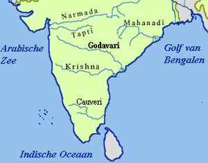
| Rivers |
|    | |||||||||||||||||||||||||
|---|---|---|---|---|---|---|---|---|---|---|---|---|---|---|---|---|---|---|---|---|---|---|---|---|---|---|---|
| Dams, barrages | |||||||||||||||||||||||||||
| Geographical features / regions | |||||||||||||||||||||||||||
| Riparian districts |
| ||||||||||||||||||||||||||
| Cities | |||||||||||||||||||||||||||
| Languages / people | |||||||||||||||||||||||||||
| Coalfields | |||||||||||||||||||||||||||
| Oil / gas fields | |||||||||||||||||||||||||||
| Industries |
| ||||||||||||||||||||||||||
| Transport | |||||||||||||||||||||||||||
| Related topics | |||||||||||||||||||||||||||
| Other basins | |||||||||||||||||||||||||||
| States | ||
|---|---|---|
| Union Territories | ||
| Related topics | ||
Coordinates: 17°57′N 79°30′E / 17.95°N 79.5°E