Lüderitz Bay
| Lüderitz Bay Lüderitzbaai Angra Pequena  | |
|---|---|
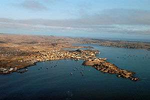 View of the eastern headland and the inner bay. | |
| Coordinates | 26°37′S 15°9′E / 26.617°S 15.150°ECoordinates: 26°37′S 15°9′E / 26.617°S 15.150°E |
| Ocean/sea sources | Atlantic Ocean |
| Basin countries | Namibia |
| Max. length | 7.5 km (4.7 mi) |
| Max. width | 5 km (3.1 mi) |
| Islands | Penguin Island and Seal Island |
| Settlements | Lüderitz[1] |
Lüderitz Bay or Lüderitzbaai (German: Lüderitzbucht), also known as Angra Pequena (Portuguese for "small cove"), is a bay in the coast of Namibia, Africa. The city of Lüderitz is located at the edge of the bay.[2]
Geography
The bay is indented and complex in structure. It opens to the Atlantic Ocean in the west. Lüderitz town is located in the southern shore of the inner eastern bay, which is known as Angra Pequena in Portuguese and opens towards the north. Further west Griffith Bay, a deep inlet, stretches southwards in the southern part.
The bay west of 'Angra Point' is known as Shearwater Bay, the location of a proposed port for the export of amongst other things, coal from Botswana. This requires the construction of the 1600 km Trans Kalahari Railway.[3]
There are two islands facing Agate Beach in the northeastern part of the bay, Penguin Island and Seal Island.[2]
History
The easternmost bay was named Angra Pequena when first mapped in 1487 by Portuguese explorer Bartolomeu Dias, although in some maps it appeared as Angra de São Christóvão. In 1883 the bay area was made into a trading station by German trader Adolf Lüderitz. He renamed it Lüderitz and concluded treaties with the neighbouring chiefs, who ceded large tracts of country to the newcomers. Under the belief that Britain was about to claim the area as a protectorate, Lüderitz transferred his rights over the bay on 24 April 1884 to the German Imperial Government, and on the following 7 August Chancellor Otto von Bismarck proclaimed a German protectorate over the station and the surrounding area.
Renamed Lüderitzbucht (Lüderitz Bay) by the Germans, the location then became a naval base for German South-West Africa, modern day Namibia.
The two islands off Agate Beach, rich in guano deposits, were annexed by Great Britain in 1867 and added to Cape Colony in 1874 as part of the offshore territory known as 'Penguin Islands'.[4]
See also
References
- ↑ GoogleEarth
- 1 2 "Lüderitzbaai". Mapcarta. Retrieved 14 October 2016.
- ↑ Railways Africa - Trans Kalahari Railway
- ↑ The map of Africa by treaty. Books.google.com. 1. pp. 345–46.