Main Street Historic District (Cromwell, Connecticut)
|
Main Street Historic District | |
  | |
| Location |
Roughly bounded by Nooks Hill Rd., Prospect Hill Rd., Wall and West Sts. and New Ln., and Stevens Ln. and Main St. Cromwell, Connecticut |
|---|---|
| Coordinates | 41°36′14″N 72°38′49″W / 41.604°N 72.647°WCoordinates: 41°36′14″N 72°38′49″W / 41.604°N 72.647°W |
| Area | 130 acres (53 ha) |
| NRHP Reference # | 85003389[1] |
| Added to NRHP | October 24, 1985 |
The Main Street Historic District in Cromwell, Connecticut is roughly bounded by Nooks Hill Rd., Prospect Hill Rd., Wall and West Sts. and New Ln., and Stevens Ln. and Main St.
It includes two town greens (Valour Green and Memorial Green), historic homes and the Cromwell Historical Society. The historic district is primarily linear and starts from "Patriots Corner" (a grassy area at the corner of Main and Wall Streets with several memorials) and runs north along Main Street (Route 99) past the Memorial Green at Wall Street. Towards the northern end, the district widens to encompass both Main Street and Prospect Hill Road until about Nooks Hill Road, including the Valour Green. The district comprises 66 contributing buildings and structures and has an area of 130 acres (0.53 km2). The district is notable in capturing the transformation of a rural 18th-century village center into a 20th-century town, with representative architecture from every major architectural style seen between 1750 and 1935.[2] The district was listed on the National Register of Historic Places in 1985.[1]
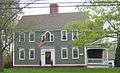 A historic home in the Main Street Historic District of Cromwell, CT
 The Valour Green between Main Street and Prospect Hill Roads
 Trees on the Town Green between Main Street and Prospect Hill Roads
 Riley-Gridley House in the Main Street Historic District of Cromwell, CT
See also
References
- 1 2 National Park Service (2009-03-13). "National Register Information System". National Register of Historic Places. National Park Service.
- ↑ "NRHP nomination for Main Street Historic District" (PDF). National Park Service. Retrieved 2014-11-25.
| Topics | |
|---|---|
| Lists by states |
|
| Lists by insular areas | |
| Lists by associated states | |
| Other areas | |
| |
