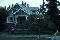
| [3] |
Name on the Register[4] |
Image |
Date listed[5] |
Location |
City or town |
Description |
|---|
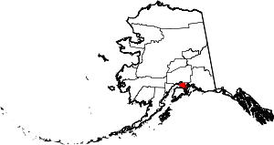
| 1 |
A.E.C. Cottage No. 23 |
|
000000001990-06-11-0000June 11, 1990
(#90000825) |
618 Christensen Drive
61°13′12″N 149°53′41″W / 61.220083°N 149.894611°W / 61.220083; -149.894611 (A.E.C. Cottage No. 23) |
Anchorage |
|
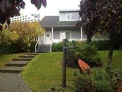
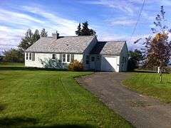
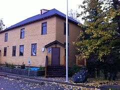
| 2 |
Alaska Engineering Commission Cottage No. 25 |
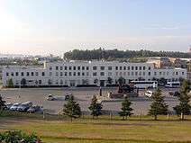
|
000000001996-02-16-0000February 16, 1996
(#96000094) |
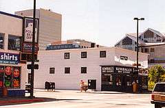
645 West Third Avenue
61°13′11″N 149°53′43″W / 61.219722°N 149.895278°W / 61.219722; -149.895278 (Alaska Engineering Commission Cottage No. 25) |
Anchorage |
|
| 3 |
Mike Alex Cabin |
Upload image |
000000001982-09-08-0000September 8, 1982
(#82002071) |
Off Alaska Route 1
61°27′43″N 149°21′30″W / 61.461944°N 149.358333°W / 61.461944; -149.358333 (Mike Alex Cabin) |
Eklutna |
|
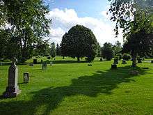
| 4 |
Anchorage Cemetery |
|
000000001993-04-26-0000April 26, 1993
(#93000320) |
535 East Ninth Avenue
61°12′57″N 149°52′27″W / 61.215833°N 149.874167°W / 61.215833; -149.874167 (Anchorage Cemetery) |
Anchorage |
|
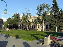
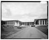
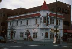
| 5 |
Anchorage City Hall |
|
000000001980-12-02-0000December 2, 1980
(#80000745) |
524 West Fourth Avenue
61°13′05″N 149°53′33″W / 61.218194°N 149.8925°W / 61.218194; -149.8925 (Anchorage City Hall) |
Anchorage |
The city's 1936 city hall.
|
| 6 |
Anchorage Depot |
|
000000001999-08-27-0000August 27, 1999
(#99001027) |
411 West First Avenue
61°13′18″N 149°53′26″W / 61.221667°N 149.890556°W / 61.221667; -149.890556 (Anchorage Depot) |
Anchorage |
|
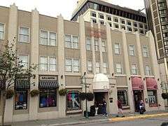
| 7 |
Anchorage Hotel Annex |
|
000000001999-04-15-0000April 15, 1999
(#99000443) |
330 E Street
61°13′08″N 149°53′31″W / 61.218889°N 149.891806°W / 61.218889; -149.891806 (Anchorage Hotel Annex) |
Anchorage |
|
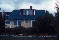
| 8 |
Oscar Anderson House |
|
000000001978-06-13-0000June 13, 1978
(#78000514) |
420 M Street
61°13′07″N 149°54′22″W / 61.218556°N 149.906028°W / 61.218556; -149.906028 (Oscar Anderson House) |
Anchorage |
|
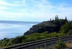
| 9 |
Beluga Point Site |
|
000000001978-03-30-0000March 30, 1978
(#78000515) |
Address Restricted
|
Anchorage |
|
| 10 |
Campus Center |
|
000000001979-06-22-0000June 22, 1979
(#79000409) |
4101 University Drive
61°11′27″N 149°48′12″W / 61.190972°N 149.803333°W / 61.190972; -149.803333 (Campus Center) |
Anchorage |
Also known as Atwood Campus Center of Alaska Pacific University.
|
| 11 |
Civil Works Residential Dwellings |
|
000000002004-07-21-0000July 21, 2004
(#04000717) |
786 and 800 Delaney Street
61°13′40″N 149°53′20″W / 61.227722°N 149.888972°W / 61.227722; -149.888972 (Civil Works Residential Dwellings) |
Anchorage |
|
| 12 |
Crow Creek Consolidated Gold Mining Company |
|
000000001978-09-13-0000September 13, 1978
(#78000517) |
Crow Creek Road
60°59′54″N 149°04′48″W / 60.998333°N 149.08°W / 60.998333; -149.08 (Crow Creek Consolidated Gold Mining Company) |
Girdwood |
|
| 13 |
Leopold David House |
|
000000001986-07-24-0000July 24, 1986
(#86001900) |
605 West Second Avenue
61°13′15″N 149°53′38″W / 61.220722°N 149.893917°W / 61.220722; -149.893917 (Leopold David House) |
Anchorage |
|
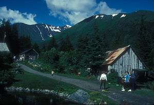
| 14 |
Eklutna Power Plant |
Upload image |
000000001980-06-20-0000June 20, 1980
(#80000746) |
Northeast of central Anchorage
61°27′21″N 149°20′04″W / 61.455833°N 149.334444°W / 61.455833; -149.334444 (Eklutna Power Plant) |
Anchorage |
Anchorage's first hydroelectric plant, built 1929 (not the current one).
|
| 15 |
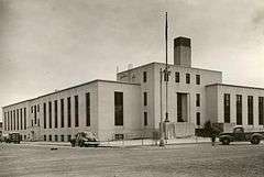
Federal Building-U.S. Courthouse |
|
000000001978-06-23-0000June 23, 1978
(#78000516) |
605 West Fourth Avenue
61°13′08″N 149°53′41″W / 61.218889°N 149.894722°W / 61.218889; -149.894722 (Federal Building-U.S. Courthouse) |
Anchorage |
|
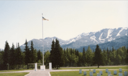
| 16 |
Fort Richardson National Cemetery |
|
000000002012-03-07-0000March 7, 2012
(#12000056) |
Building 58-512, Davis Highway
61°16′31″N 149°39′35″W / 61.275369°N 149.659846°W / 61.275369; -149.659846 (Fort Richardson National Cemetery) |
Fort Richardson |
|
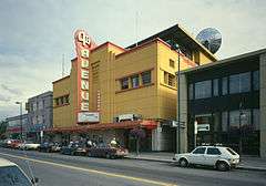
| 17 |
Fourth Avenue Theatre (AHRS Site No. ANC-284) |
|
000000001982-10-05-0000October 5, 1982
(#82001620) |
630 West Fourth Avenue
61°13′06″N 149°53′40″W / 61.218333°N 149.8945°W / 61.218333; -149.8945 (Fourth Avenue Theatre (AHRS Site No. ANC-284)) |
Anchorage |
|
| 18 |
Oscar Gill House |
Upload image |
000000002001-02-02-0000February 2, 2001
(#01000022) |
1344 West Tenth Avenue
61°12′45″N 149°54′34″W / 61.212444°N 149.909417°W / 61.212444; -149.909417 (Oscar Gill House) |
Anchorage |
Moved here from its original site at 918 West Tenth Avenue ca. 1983
|
| 19 |
Government Hill Federal Housing Historic District |
Upload image |
000000002015-01-14-0000January 14, 2015
(#14001147) |
W. Harvard, Delaney & Brown Sts.
61°13′42″N 149°53′11″W / 61.2283°N 149.8863°W / 61.2283; -149.8863 (Government Hill Federal Housing Historic District) |
Anchorage |
|
| 20 |
Indian Valley Mine |
Upload image |
000000001989-10-25-0000October 25, 1989
(#89001762) |
Address Restricted
|
Indian |
|
| 21 |
KENI Radio Building |
|
000000001988-04-18-0000April 18, 1988
(#88000380) |
1777 Forest Park Drive
61°12′19″N 149°55′31″W / 61.205389°N 149.925222°W / 61.205389; -149.925222 (KENI Radio Building) |
Anchorage |
|
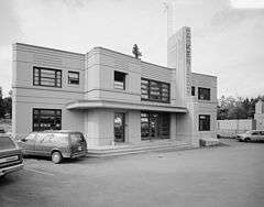
| 22 |
Kimball's Store |
|
000000001986-07-24-0000July 24, 1986
(#86001901) |
500 and 504 West Fifth Avenue
61°13′03″N 149°53′30″W / 61.217444°N 149.891778°W / 61.217444; -149.891778 (Kimball's Store) |
Anchorage |
|
| 23 |
Loussac-Sogn Building |
Upload image |
000000001998-05-20-0000May 20, 1998
(#98000567) |
429 D Street
61°13′04″N 149°53′21″W / 61.217778°N 149.889167°W / 61.217778; -149.889167 (Loussac-Sogn Building) |
Anchorage |
See Zachariah J. Loussac
|
| 24 |
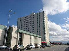
McKinley Tower Apartments |
|
000000002008-09-12-0000September 12, 2008
(#08000882) |
337 East Fourth Avenue
61°13′08″N 149°52′39″W / 61.218778°N 149.877444°W / 61.218778; -149.877444 (McKinley Tower Apartments) |
Anchorage |
|
| 25 |
Mt. Alyeska Roundhouse |
Upload image |
000000002003-11-05-0000November 5, 2003
(#02000562) |
Approximately 2 miles (3.2 km) west of Alyeska
60°57′45″N 149°04′27″W / 60.9625°N 149.074167°W / 60.9625; -149.074167 (Mt. Alyeska Roundhouse) |
Girdwood |
Part of Alyeska Resort
|
| 26 |
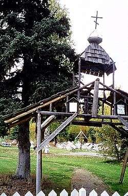
Old St. Nicholas Russian Orthodox Church |
|
000000001972-03-24-0000March 24, 1972
(#72000189) |
Eklutna Village Rd.
61°27′39″N 149°21′41″W / 61.4608°N 149.3614°W / 61.4608; -149.3614 (Old St. Nicholas Russian Orthodox Church) |
Eklutna |
|
| 27 |
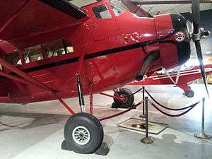
Pilgrim 100B Aircraft |
|
000000001986-08-07-0000August 7, 1986
(#86002230) |
Alaska Aviation Heritage Museum
61°10′41″N 149°58′16″W / 61.178°N 149.9711°W / 61.178; -149.9711 (Pilgrim 100B Aircraft) |
Anchorage |
Originally listed at Dillingham Airport, this aircraft is now in the collection of the Alaska Aviation Heritage Museum.
|
| 28 |
Pioneer School House |
|
000000001980-12-03-0000December 3, 1980
(#80000747) |
437 East 3rd Avenue
61°13′12″N 149°52′32″W / 61.219889°N 149.875639°W / 61.219889; -149.875639 (Pioneer School House) |
Anchorage |
|
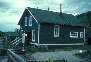
| 29 |
Potter Section House |
|
000000001985-12-06-0000December 6, 1985
(#85003113) |
Off Alaska Route 1
61°03′07″N 149°47′49″W / 61.051944°N 149.796806°W / 61.051944; -149.796806 (Potter Section House) |
Anchorage |
|
| 30 |
Site Summit |
|
000000001996-07-11-0000July 11, 1996
(#96000691) |
Off Arctic Valley Road, 12.5 miles (20.1 km) east of central Anchorage
61°15′29″N 149°31′41″W / 61.258056°N 149.528056°W / 61.258056; -149.528056 (Site Summit) |
Anchorage |
|
| 31 |
Spring Creek Lodge |
Upload image |
000000002001-09-09-0000September 9, 2001
(#01000938) |
18939 Old Glenn Highway
61°23′29″N 149°27′53″W / 61.391389°N 149.464722°W / 61.391389; -149.464722 (Spring Creek Lodge) |
Chugiak |
|
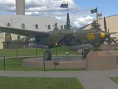
| 32 |
Temnac P-38G Lightning |
|
000000001979-06-26-0000June 26, 1979
(#79000406) |
McCloud Memorial Park, Elmendorf Air Force Base[6]
61°14′54″N 149°48′07″W / 61.2483°N 149.8019°W / 61.2483; -149.8019 (Temnac P-38G Lightning) |
Anchorage |
A P-38G grounded on Attu Island during World War II, it was recovered in the 1990s, restored, and moved to its current location in April 2000.[6]
|
| 33 |
Wendler Building |
|
000000001988-06-24-0000June 24, 1988
(#88000730) |
400 D Street
61°13′06″N 149°53′23″W / 61.218389°N 149.889667°W / 61.218389; -149.889667 (Wendler Building) |
Anchorage |
Moved here from its original site at 402 I Street c. 1985
|
| 34 |
The Wireless Station |
Upload image |
000000002015-12-01-0000December 1, 2015
(#15000843) |
124–140 East Manor Avenue
61°13′45″N 149°52′53″W / 61.229299°N 149.881427°W / 61.229299; -149.881427 (The Wireless Station) |
Anchorage |
|