| [3] |
Name on the Register[4] |
Image |
Date listed[5] |
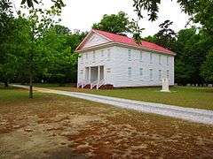
Location |
City or town |
Description |
|---|
| 1 |
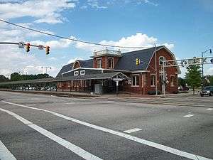
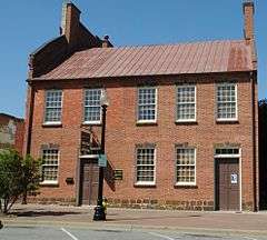
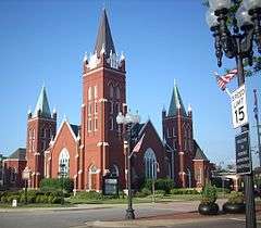
Atlantic Coast Line Railroad Station |
|
000000001982-07-07-0000July 7, 1982
(#82001294) |
472 Hay St.
35°03′18″N 78°53′05″W / 35.055°N 78.884722°W / 35.055; -78.884722 (Atlantic Coast Line Railroad Station) |
Fayetteville |
part of the Fayetteville MRA
|
| 2 |
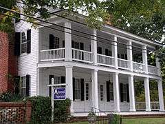
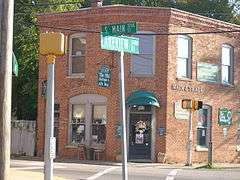
Barge's Tavern |
|
000000001983-07-07-0000July 7, 1983
(#83001843) |
519 Ramsey St.
35°03′39″N 78°52′42″W / 35.060833°N 78.878333°W / 35.060833; -78.878333 (Barge's Tavern) |
Fayetteville |
part of the Fayetteville MRA
|
| 3 |
Belden-Horne House |
|
000000001972-03-16-0000March 16, 1972
(#72000955) |
519 Ramsey St.
35°03′39″N 78°52′42″W / 35.060833°N 78.878333°W / 35.060833; -78.878333 (Belden-Horne House) |
Fayetteville |
|
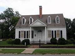
| 4 |
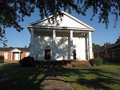
Big Rockfish Presbyterian Church |
|
000000001983-07-21-0000July 21, 1983
(#83001844) |
SR 2268
34°57′06″N 78°55′27″W / 34.951667°N 78.924167°W / 34.951667; -78.924167 (Big Rockfish Presbyterian Church) |
Hope Mills |
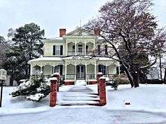
|
| 5 |
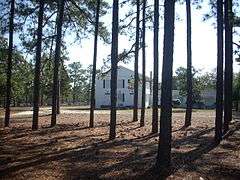
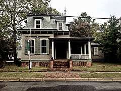
Brownlea |
|
000000002003-08-21-0000August 21, 2003
(#03000803) |
405 Southampton Court
35°03′08″N 78°54′53″W / 35.052222°N 78.914722°W / 35.052222; -78.914722 (Brownlea) |
Fayetteville |
|
| 6 |
Camp Ground Methodist Church |
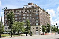
|
000000001983-07-07-0000July 7, 1983
(#83001845) |
Camp Ground Rd.
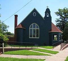
35°04′04″N 78°58′22″W / 35.067778°N 78.972778°W / 35.067778; -78.972778 (Camp Ground Methodist Church) |
Fayetteville |
part of the Fayetteville MRA
|
| 7 |
Cape Fear and Yadkin Valley Railway Passenger Depot |
|
000000001983-07-07-0000July 7, 1983
(#83001846) |
148 Maxwell St.
35°03′08″N 78°52′56″W / 35.052222°N 78.882222°W / 35.052222; -78.882222 (Cape Fear and Yadkin Valley Railway Passenger Depot) |
Fayetteville |
part of the Fayetteville MRA
|
| 8 |
Cape Fear Baptist Church |
|
000000001983-10-13-0000October 13, 1983
(#83003816) |
SR 2233
34°54′21″N 78°49′37″W / 34.905833°N 78.826944°W / 34.905833; -78.826944 (Cape Fear Baptist Church) |
Grays Creek |
|
| 9 |
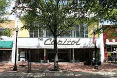
The Capitol |
|
000000002005-05-04-0000May 4, 2005
(#05000376) |
126 Hay St.
35°03′18″N 78°52′45″W / 35.055°N 78.879167°W / 35.055; -78.879167 (The Capitol) |
Fayetteville |
|
| 10 |
Carolina Theater |
Upload image |
000000001983-07-07-0000July 7, 1983
(#83001847) |
443 Hay St.
35°03′15″N 78°53′03″W / 35.054167°N 78.884167°W / 35.054167; -78.884167 (Carolina Theater) |
Fayetteville |
Destroyed;[6] part of the Fayetteville MRA
|
| 11 |
Confederate Breastworks |
|
000000001981-10-07-0000October 7, 1981
(#81000421) |
2300 Ramsey St.
35°05′19″N 78°52′34″W / 35.088688°N 78.87613°W / 35.088688; -78.87613 (Confederate Breastworks) |
Fayetteville |
|
| 12 |
Cool Spring Place |
|
000000001972-10-10-0000October 10, 1972
(#72000956) |
119 N. Cool Spring St.
35°03′08″N 78°52′30″W / 35.052222°N 78.875°W / 35.052222; -78.875 (Cool Spring Place) |
Fayetteville |
|
| 13 |
Cool Springs |
Upload image |
000000001985-09-19-0000September 19, 1985
(#85002417) |
Off SR 1607 at Cumberland
35°14′02″N 78°52′29″W / 35.233889°N 78.874722°W / 35.233889; -78.874722 (Cool Springs) |
Carvers Creek |
|
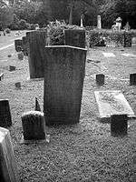
| 14 |
Cross Creek Cemetery Number One |
|
000000001998-09-25-0000September 25, 1998
(#98001209) |
Junction of N. Cool Spring and Grove St.
35°03′17″N 78°52′23″W / 35.054722°N 78.873056°W / 35.054722; -78.873056 (Cross Creek Cemetery Number One) |
Fayetteville |
Also see Cross Creek Cemetery
|
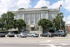
| 15 |
Cumberland County Courthouse |
|
000000001979-05-10-0000May 10, 1979
(#79001696) |
Franklin, Gillespie, and Russell Sts.
35°03′05″N 78°52′45″W / 35.051389°N 78.879167°W / 35.051389; -78.879167 (Cumberland County Courthouse) |
Fayetteville |
part of the North Carolina County Courthouses Thematic Resource
|
| 16 |
John Davis House |
Upload image |
000000001983-07-07-0000July 7, 1983
(#83001848) |
910 Arsenal Ave.
35°03′18″N 78°53′45″W / 35.055°N 78.895833°W / 35.055; -78.895833 (John Davis House) |
Fayetteville |
part of the Fayetteville MRA
|
| 17 |
Devane-MacQueen House |
Upload image |
000000001983-07-21-0000July 21, 1983
(#83001849) |
NC 87
34°52′50″N 78°50′33″W / 34.880556°N 78.8425°W / 34.880556; -78.8425 (Devane-MacQueen House) |
Grays Creek |
|
| 18 |
Ellerslie |
Upload image |
000000001974-08-07-0000August 7, 1974
(#74001344) |
West of Linden on SR 1607 at the junction with SR 1606
35°13′50″N 78°52′31″W / 35.230556°N 78.875278°W / 35.230556; -78.875278 (Ellerslie) |
Linden |
|
| 19 |
Evans Metropolitan AME Zion Church |
|
000000001983-07-07-0000July 7, 1983
(#83001850) |
301 N. Cool Spring St.
35°03′12″N 78°52′53″W / 35.053333°N 78.881389°W / 35.053333; -78.881389 (Evans Metropolitan AME Zion Church) |
Fayetteville |
part of the Fayetteville MRA
|
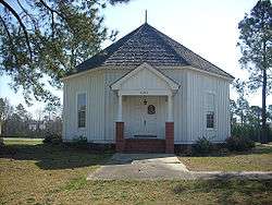
| 20 |
Falcon Tabernacle |
|
000000001983-10-11-0000October 11, 1983
(#83003814) |
West St.
35°11′37″N 78°38′52″W / 35.193611°N 78.647778°W / 35.193611; -78.647778 (Falcon Tabernacle) |
Falcon |
|
| 21 |
Fayetteville Downtown Historic District |
|
000000001999-07-01-0000July 1, 1999
(#99000779) |
Roughly along Hay, Person, Green, Gillespie, Bow, Old, W. Russell and Cool Spring Sts.
35°03′11″N 78°52′41″W / 35.053056°N 78.878056°W / 35.053056; -78.878056 (Fayetteville Downtown Historic District) |
Fayetteville |
|
| 22 |
Fayetteville Ice and Manufacturing Company:Plant and Engineer's House |
Upload image |
000000001983-07-07-0000July 7, 1983
(#83001851) |
436 Rowan St. and 438 Rowan St.
35°03′36″N 78°53′00″W / 35.06°N 78.883333°W / 35.06; -78.883333 (Fayetteville Ice and Manufacturing Company:Plant and Engineer's House) |
Fayetteville |
part of the Fayetteville MRA
|
| 23 |
Fayetteville Mutual Insurance Company Building |
|
000000001983-07-07-0000July 7, 1983
(#83001852) |
320 Hay St.
35°03′14″N 78°52′54″W / 35.053889°N 78.881667°W / 35.053889; -78.881667 (Fayetteville Mutual Insurance Company Building) |
Fayetteville |
part of the Fayetteville MRA
|
| 24 |
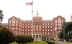
Fayetteville Veterans Administration Hospital Historic District |
|
000000002012-09-19-0000September 19, 2012
(#12000799) |
2300 Ramsey St.
35°05′19″N 78°52′34″W / 35.088688°N 78.87613°W / 35.088688; -78.87613 (Fayetteville Veterans Administration Hospital Historic District) |
Fayetteville |
part of the United States Second Generation Veterans Hospitals Multiple Property Submission (MPS)
|
| 25 |
Fayetteville Women's Club and Oval Ballroom |
|
000000001973-02-06-0000February 6, 1973
(#73001330) |
224 Dick St.
35°02′53″N 78°52′42″W / 35.048056°N 78.878333°W / 35.048056; -78.878333 (Fayetteville Women's Club and Oval Ballroom) |
Fayetteville |
Fayetteville Women's Club is also known as Sandford House
|
| 26 |
First Baptist Church |
|
000000001983-07-07-0000July 7, 1983
(#83001853) |
200 Old St.
35°03′14″N 78°52′47″W / 35.053889°N 78.879722°W / 35.053889; -78.879722 (First Baptist Church) |
Fayetteville |
part of the Fayetteville MRA
|
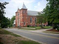
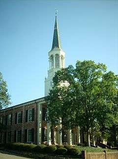
| 27 |
First Presbyterian Church |
|
000000001976-04-30-0000April 30, 1976
(#76001317) |
Ann and Bow Sts.
35°03′12″N 78°52′32″W / 35.053333°N 78.875556°W / 35.053333; -78.875556 (First Presbyterian Church) |
Fayetteville |
|
| 28 |
Gully Mill |
Upload image |
000000001983-07-07-0000July 7, 1983
(#83001854) |
S.R. 1839
35°03′22″N 78°50′29″W / 35.056111°N 78.841389°W / 35.056111; -78.841389 (Gully Mill) |
Fayetteville |
part of the Fayetteville MRA
|
| 29 |
Hangars 4 and 5, Pope Air Force Base |
Upload image |
000000001991-01-16-0000January 16, 1991
(#90002153) |
Bldg. 708, Pope AFB
35°10′40″N 79°00′52″W / 35.177778°N 79.014444°W / 35.177778; -79.014444 (Hangars 4 and 5, Pope Air Force Base) |
Fayetteville |
part of the Pope Air Force Base Early Expansion MPS
|
| 30 |
Hay Street Methodist Church |
|
000000001983-07-07-0000July 7, 1983
(#83001855) |
Hay St. at Ray and Old Sts.
35°03′11″N 78°52′27″W / 35.053056°N 78.874167°W / 35.053056; -78.874167 (Hay Street Methodist Church) |
Fayetteville |
part of the Fayetteville MRA
|
| 31 |
Haymount District |
|
000000001983-08-07-0000August 7, 1983
(#83001856) |
Roughly Hillside Ave. from Bragg Boulevard to Purshing St.
• Boundary increase (listed 000000002007-04-10-0000April 10, 2007, refnum 07000296): 100-200 blocks of Bradford Ave., 801 Hay St., and 801, 802, and 806 Arsenal Ave.
35°03′24″N 78°53′22″W / 35.056667°N 78.889444°W / 35.056667; -78.889444 (Haymount District) |
Fayetteville |
part of the Fayetteville MRA
|
| 32 |
Holt-Harrison House |
|
000000001983-07-07-0000July 7, 1983
(#83001857) |
806 Hay St.
35°03′22″N 78°53′33″W / 35.056111°N 78.8925°W / 35.056111; -78.8925 (Holt-Harrison House) |
Fayetteville |
part of the Fayetteville MRA
|
| 33 |
Hope Mills Historic District |
|
000000001985-07-09-0000July 9, 1985
(#85001515) |
Roughly bounded by Seaboard Coastline RR tracks, Lakeview Rd., Little Creek and Cross St.
34°58′17″N 78°56′43″W / 34.971389°N 78.945278°W / 34.971389; -78.945278 (Hope Mills Historic District) |
Hope Mills |
|
| 34 |
Kyle House |
|
000000001972-06-19-0000June 19, 1972
(#72000957) |
234 Green St.
35°03′21″N 78°52′36″W / 35.055833°N 78.876667°W / 35.055833; -78.876667 (Kyle House) |
Fayetteville |
|
| 35 |
Liberty Row |
|
000000001973-08-14-0000August 14, 1973
(#73001331) |
N Side of the first block of Person St., bounded by Market Sq. and Liberty Point
35°03′08″N 78°52′39″W / 35.052222°N 78.8775°W / 35.052222; -78.8775 (Liberty Row) |
Fayetteville |
|
| 36 |
Long Valley Farm |
|
000000001994-06-06-0000June 6, 1994
(#94000032) |
Address Restricted
|
Spring Lake |
|
| 37 |
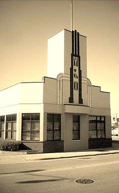
M & O Chevrolet Company |
|
000000001983-07-07-0000July 7, 1983
(#83001858) |
412 W. Russell St.
35°03′11″N 78°53′05″W / 35.053056°N 78.884722°W / 35.053056; -78.884722 (M & O Chevrolet Company) |
Fayetteville |
part of the Fayetteville MRA
|
| 38 |
Mansard Roof House |
|
000000001973-03-20-0000March 20, 1973
(#73001332) |
214 Mason St.
35°03′21″N 78°52′45″W / 35.055833°N 78.879167°W / 35.055833; -78.879167 (Mansard Roof House) |
Fayetteville |
|
| 39 |
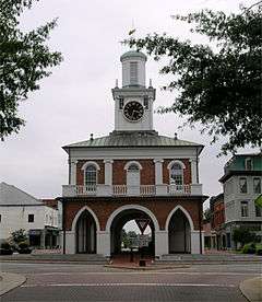
Market House |
|
000000001970-09-15-0000September 15, 1970
(#70000451) |
Market Sq.
35°03′10″N 78°52′40″W / 35.052778°N 78.877778°W / 35.052778; -78.877778 (Market House) |
Fayetteville |
|
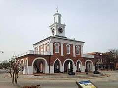
| 40 |
Market House Square District |
|
000000001983-07-07-0000July 7, 1983
(#83001860) |
Hay, Person, Green, and Gillespie Sts.
35°03′09″N 78°52′44″W / 35.0525°N 78.878889°W / 35.0525; -78.878889 (Market House Square District) |
Fayetteville |
part of the Fayetteville MRA
|
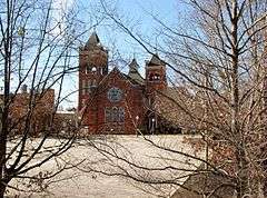
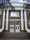
| 41 |
Massey Hill High School |
|
000000002004-12-23-0000December 23, 2004
(#04001387) |
1062 Southern Ave.
35°01′51″N 78°53′40″W / 35.030861°N 78.894325°W / 35.030861; -78.894325 (Massey Hill High School) |
Fayetteville |
|
| 42 |
Maxwell House |
Upload image |
000000001985-02-28-0000February 28, 1985
(#85000380) |
Off NC 24
35°01′18″N 78°43′23″W / 35.021667°N 78.723056°W / 35.021667; -78.723056 (Maxwell House) |
Stedman |
|
| 43 |
McArthur-Council House |
Upload image |
000000001983-07-21-0000July 21, 1983
(#83001861) |
SR 2244
34°53′38″N 78°55′58″W / 34.893889°N 78.932778°W / 34.893889; -78.932778 (McArthur-Council House) |
Grays Creek |
|
| 44 |
McCall House |
|
000000001983-07-07-0000July 7, 1983
(#83001862) |
822 Arsenal Ave.
35°03′18″N 78°53′39″W / 35.055°N 78.894167°W / 35.055; -78.894167 (McCall House) |
Fayetteville |
part of the Fayetteville MRA
|
| 45 |
William McDiarmid House |
|
000000001983-07-07-0000July 7, 1983
(#83001863) |
330 Dick St.
35°02′51″N 78°52′45″W / 35.0475°N 78.879167°W / 35.0475; -78.879167 (William McDiarmid House) |
Fayetteville |
part of the Fayetteville MRA
|
| 46 |
Henry McLean House |
Upload image |
000000001983-07-07-0000July 7, 1983
(#83001864) |
1006 Hay St.
35°03′23″N 78°53′50″W / 35.056389°N 78.897222°W / 35.056389; -78.897222 (Henry McLean House) |
Fayetteville |
part of the Fayetteville MRA
|
| 47 |
Nimocks House |
|
000000001972-01-20-0000January 20, 1972
(#72000958) |
225 Dick St.
35°03′01″N 78°52′34″W / 35.050278°N 78.876111°W / 35.050278; -78.876111 (Nimocks House) |
Fayetteville |
|
| 48 |
North Carolina Arsenal Site |
|
000000001983-02-23-0000February 23, 1983
(#83001865) |
Arsenal Park, behind the Museum of the Cape Fear Historical Complex
35°03′14″N 78°53′41″W / 35.054°N 78.8947°W / 35.054; -78.8947 (North Carolina Arsenal Site) |
Fayetteville |
Remains of a US (and later Confederate) Army arsenal
|
| 49 |
Oak Grove |
Upload image |
000000001973-02-06-0000February 6, 1973
(#73001329) |
South of Erwin near the junction of NC 82 and SR 1875
35°15′00″N 78°41′25″W / 35.25°N 78.690278°W / 35.25; -78.690278 (Oak Grove) |
Erwin |
|
| 50 |
John A. Oates House |
Upload image |
000000001983-07-07-0000July 7, 1983
(#83001866) |
406 St. James Sq.
35°03′26″N 78°52′35″W / 35.057222°N 78.876389°W / 35.057222; -78.876389 (John A. Oates House) |
Fayetteville |
part of the Fayetteville MRA
|
| 51 |
Old Bluff Presbyterian Church |
|
000000001974-08-07-0000August 7, 1974
(#74001345) |
North of Wade on SR 1709
35°11′02″N 78°43′25″W / 35.183889°N 78.723611°W / 35.183889; -78.723611 (Old Bluff Presbyterian Church) |
Wade |
|
| 52 |
Orange Street School |
|
000000001987-09-22-0000September 22, 1987
(#87001597) |
500 block of Orange St., at the junction of Orange and Chance Sts.
35°03′50″N 78°52′49″W / 35.063889°N 78.880278°W / 35.063889; -78.880278 (Orange Street School) |
Fayetteville |
|
| 53 |
John E. Patterson House |
Upload image |
000000001983-07-07-0000July 7, 1983
(#83001867) |
445 Moore St.
35°03′41″N 78°53′02″W / 35.061389°N 78.883889°W / 35.061389; -78.883889 (John E. Patterson House) |
Fayetteville |
part of the Fayetteville MRA
|
| 54 |
Phoenix Masonic Lodge No. 8 |
|
000000001983-07-07-0000July 7, 1983
(#83001868) |
221 Mason St.
35°03′21″N 78°52′48″W / 35.055833°N 78.88°W / 35.055833; -78.88 (Phoenix Masonic Lodge No. 8) |
Fayetteville |
part of the Fayetteville MRA
|
| 55 |
Edgar Allan Poe House |
|
000000001983-07-07-0000July 7, 1983
(#83001869) |
206 Bradford Ave.
35°03′14″N 78°52′47″W / 35.053889°N 78.879722°W / 35.053889; -78.879722 (Edgar Allan Poe House) |
Fayetteville |
part of the Fayetteville MRA
|
| 56 |
Pope Air Force Base Historic District |
Upload image |
000000001991-01-25-0000January 25, 1991
(#90002152) |
Bldgs. 300, 302, 306, and Old Family Housing Units
35°10′13″N 79°00′13″W / 35.170278°N 79.003611°W / 35.170278; -79.003611 (Pope Air Force Base Historic District) |
Fayetteville |
part of the Pope Air Force Base Early Expansion MPS
|
| 57 |
Prince Charles Hotel |
|
000000001983-07-07-0000July 7, 1983
(#83001870) |
430 Hay St.
35°03′16″N 78°53′00″W / 35.054444°N 78.883333°W / 35.054444; -78.883333 (Prince Charles Hotel) |
Fayetteville |
built 1925; also known as Hotel Prince Charles;[7] part of the Fayetteville MRA
|
| 58 |
Sedberry-Holmes House |
|
000000001975-09-02-0000September 2, 1975
(#75001252) |
232 Person St.
35°03′04″N 78°52′33″W / 35.051111°N 78.875833°W / 35.051111; -78.875833 (Sedberry-Holmes House) |
Fayetteville |
|
| 59 |
Seventy-First Consolidated School |
|
000000002004-12-23-0000December 23, 2004
(#04001388) |
6830 Raeford Rd.
35°02′17″N 79°00′34″W / 35.038056°N 79.009444°W / 35.038056; -79.009444 (Seventy-First Consolidated School) |
Fayetteville |
|
| 60 |
Dr. Ezekiel Ezra Smith House |
|
000000002015-05-13-0000May 13, 2015
(#15000237) |
135 S. Blount St.
35°02′48″N 78°52′56″W / 35.0467°N 78.8821°W / 35.0467; -78.8821 (Dr. Ezekiel Ezra Smith House) |
Fayetteville |
|
| 61 |
St. John's Episcopal Church |
|
000000001974-09-06-0000September 6, 1974
(#74001343) |
Green St.
35°03′18″N 78°52′38″W / 35.055°N 78.877222°W / 35.055; -78.877222 (St. John's Episcopal Church) |
Fayetteville |
|
| 62 |
St. Joseph's Episcopal Church |
|
000000001982-06-01-0000June 1, 1982
(#82003447) |
Ramsey and Moore Sts.
35°03′21″N 78°52′41″W / 35.055833°N 78.878056°W / 35.055833; -78.878056 (St. Joseph's Episcopal Church) |
Fayetteville |
|
| 63 |
Frank H. Stedman House |
|
000000002002-09-14-0000September 14, 2002
(#02000966) |
1516 Morganton Rd.
35°03′30″N 78°54′18″W / 35.058333°N 78.905°W / 35.058333; -78.905 (Frank H. Stedman House) |
Fayetteville |
|
| 64 |
Robert Strange Country House |
Upload image |
000000001983-07-07-0000July 7, 1983
(#83001871) |
309 Kirkland Dr.
35°05′30″N 78°52′28″W / 35.091667°N 78.874444°W / 35.091667; -78.874444 (Robert Strange Country House) |
Fayetteville |
part of the Fayetteville MRA
|
| 65 |
Taylor-Utley House |
|
000000001983-07-07-0000July 7, 1983
(#83001872) |
916 Hay St.
35°03′23″N 78°53′46″W / 35.056389°N 78.896111°W / 35.056389; -78.896111 (Taylor-Utley House) |
Fayetteville |
part of the Fayetteville MRA
|
| 66 |
U.S. Post Office |
|
000000001983-07-07-0000July 7, 1983
(#83001873) |
301 Hay St.
35°03′12″N 78°52′53″W / 35.053333°N 78.881389°W / 35.053333; -78.881389 (U.S. Post Office) |
Fayetteville |
part of the Fayetteville MRA
|
| 67 |
Dr. William C. Verdery House |
|
000000002007-09-05-0000September 5, 2007
(#07000904) |
1428 Raeford Rd.
35°03′25″N 78°54′16″W / 35.056944°N 78.904444°W / 35.056944; -78.904444 (Dr. William C. Verdery House) |
Fayetteville |
|
| 68 |
Waddill's Store |
|
000000001983-07-07-0000July 7, 1983
(#83001874) |
220 Hay St.
35°03′12″N 78°52′49″W / 35.053333°N 78.880278°W / 35.053333; -78.880278 (Waddill's Store) |
Fayetteville |
part of the Fayetteville MRA
|
| 69 |
Westlawn |
Upload image |
000000001980-09-22-0000September 22, 1980
(#80002815) |
1505 Fort Bragg Rd.
35°03′33″N 78°54′22″W / 35.059167°N 78.906111°W / 35.059167; -78.906111 (Westlawn) |
Fayetteville |
|
| 70 |
Robert Williams House |
Upload image |
000000001983-07-21-0000July 21, 1983
(#83001875) |
SR 1728
35°05′16″N 78°48′56″W / 35.087778°N 78.815556°W / 35.087778; -78.815556 (Robert Williams House) |
Eastover |
|
.JPG)
.JPG)


.JPG)
.JPG)

.JPG)
.JPG)
.JPG)

.JPG)
.JPG)
.JPG)


.JPG)


.JPG)
.JPG)