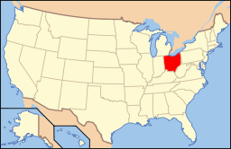
National Register of Historic Places listings in Preble County, Ohio
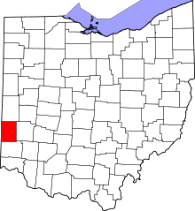
Location of Preble County in Ohio
This is a list of the National Register of Historic Places listings in Preble County, Ohio.
This is intended to be a complete list of the properties and districts on the National Register of Historic Places in Preble County, Ohio, United States. The locations of National Register properties and districts for which the latitude and longitude coordinates are included below, may be seen in a Google map.[1]
There are 19 properties and districts listed on the National Register in the county.
- This National Park Service list is complete through NPS recent listings posted December 2, 2016.[2]
Current listings
| [3] |
Name on the Register[4] |
Image |
Date listed[5] |
Location |
City or town |
Description |
|---|
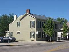
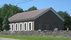
| 1 |
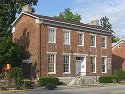
Acton House |
|
000000001985-09-05-0000September 5, 1985
(#85001944) |
115 W. Main St.
39°44′38″N 84°38′15″W / 39.74375°N 84.6375°W / 39.74375; -84.6375 (Acton House) |
Eaton |
|
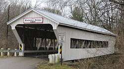
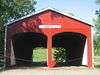
| 2 |
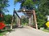
Brubaker Covered Bridge |
|
000000001975-06-11-0000June 11, 1975
(#75001527) |
West of Gratis on Aukerman Creek Rd.
39°39′06″N 84°32′39″W / 39.651667°N 84.544167°W / 39.651667; -84.544167 (Brubaker Covered Bridge) |
Gratis Township |
|
| 3 |
Bunker Hill House |
|
000000002001-09-28-0000September 28, 2001
(#01001062) |
7919 State Route 177 in Fairhaven
39°38′13″N 84°46′20″W / 39.636944°N 84.772222°W / 39.636944; -84.772222 (Bunker Hill House) |
Dixon Township |
|
| 4 |
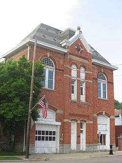
Camden City Hall and Opera House |
|
000000001998-02-12-0000February 12, 1998
(#98000100) |
54 W. Central Ave.
39°37′44″N 84°39′00″W / 39.628889°N 84.65°W / 39.628889; -84.65 (Camden City Hall and Opera House) |
Camden |
|
| 5 |
Camden Public School |
|
000000001998-01-30-0000January 30, 1998
(#98000041) |
110 W. Central Ave.
39°37′48″N 84°38′33″W / 39.63°N 84.6425°W / 39.63; -84.6425 (Camden Public School) |
Camden |
|
| 6 |
Christman Covered Bridge |
|
000000001976-10-22-0000October 22, 1976
(#76001516) |
1.5 miles northwest of Eaton
39°46′13″N 84°39′18″W / 39.770278°N 84.655000°W / 39.770278; -84.655000 (Christman Covered Bridge) |
Washington Township |
|
| 7 |
Daniel Christman Homestead |
|
000000001982-11-04-0000November 4, 1982
(#82001486) |
West of Eaton on U.S. Route 35
39°45′44″N 84°40′04″W / 39.762222°N 84.667778°W / 39.762222; -84.667778 (Daniel Christman Homestead) |
Washington Township |
|
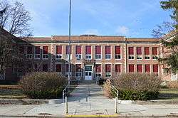
| 8 |
Eaton High School |
|
000000002014-12-15-0000December 15, 2014
(#14001052) |
307 N. Cherry St.
39°44′50″N 84°38′08″W / 39.747222°N 84.635556°W / 39.747222; -84.635556 (Eaton High School) |
Eaton |
|
| 9 |
Fort St. Clair Site |
|
000000001970-11-10-0000November 10, 1970
(#70000514) |
1 mile west of downtown Eaton
39°44′16″N 84°39′15″W / 39.737778°N 84.654167°W / 39.737778; -84.654167 (Fort St. Clair Site) |
Eaton |
|
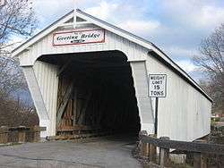
| 10 |
Geeting Covered Bridge |
|
000000001975-08-19-0000August 19, 1975
(#75001528) |
2 miles west of Lewisburg on Price Rd.
39°50′37″N 84°35′50″W / 39.843611°N 84.597222°W / 39.843611; -84.597222 (Geeting Covered Bridge) |
Monroe Township |
|
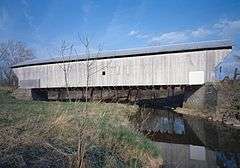
| 11 |
Harshman Covered Bridge |
|
000000001976-09-29-0000September 29, 1976
(#76001517) |
4 miles north of Fairhaven on Concord-Fairhaven Rd. spanning Four Mile Creek
39°42′09″N 84°46′11″W / 39.702500°N 84.769611°W / 39.702500; -84.769611 (Harshman Covered Bridge) |
Dixon Township |
|
| 12 |
Historic Associate Reformed Church and Cemetery |
|
000000002008-03-06-0000March 6, 2008
(#08000161) |
6471 Camden-College Corner Rd.
39°36′11″N 84°45′38″W / 39.603°N 84.7605°W / 39.603; -84.7605 (Historic Associate Reformed Church and Cemetery) |
Israel Township |
|
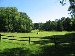
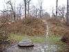
| 13 |
Hueston Woods Park Mound |
|
000000001971-11-05-0000November 5, 1971
(#71000650) |
Trail near Class A Campground in Hueston Woods State Park[6]
39°35′05″N 84°46′44″W / 39.584722°N 84.778888°W / 39.584722; -84.778888 (Hueston Woods Park Mound) |
Israel Township |
|
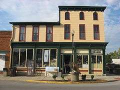
| 14 |
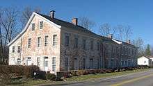
Lange Hotel |
|
000000001991-01-25-0000January 25, 1991
(#90002213) |
1 W. Dayton St.
39°44′41″N 84°31′57″W / 39.744722°N 84.5325°W / 39.744722; -84.5325 (Lange Hotel) |
West Alexandria |
|
| 15 |
Roberts Covered Bridge |
|
000000001971-09-03-0000September 3, 1971
(#71000651) |
City park in southwestern Eaton[7][8]
39°44′26″N 84°38′20″W / 39.740444°N 84.63875°W / 39.740444; -84.63875 (Roberts Covered Bridge) |
Eaton |
Moved from its original location,[7] 3 miles south of Eaton over Seven Mile Creek[4]
|
| 16 |
St. Clair Street Bridge |
|
000000001978-09-21-0000September 21, 1978
(#78002175) |
Over Seven Mile Creek
39°44′24″N 84°38′19″W / 39.74°N 84.638611°W / 39.74; -84.638611 (St. Clair Street Bridge) |
Eaton |
|
| 17 |
George B. Unger House |
|
000000001978-11-15-0000November 15, 1978
(#78002176) |
29 E. Dayton St.
39°44′40″N 84°31′51″W / 39.744444°N 84.530833°W / 39.744444; -84.530833 (George B. Unger House) |
West Alexandria |
|
| 18 |
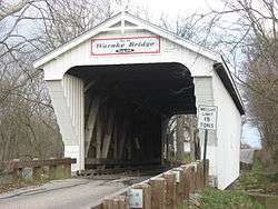
Warnke Covered Bridge |
|
000000001976-10-08-0000October 8, 1976
(#76001518) |
Northeast of Lewisburg on Swamp Creek Rd.
39°52′26″N 84°30′53″W / 39.873889°N 84.514722°W / 39.873889; -84.514722 (Warnke Covered Bridge) |
Harrison Township |
|
| 19 |
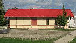
West Alexandria Depot |
|
000000002006-08-11-0000August 11, 2006
(#06000696) |
71 E. Dayton St.
39°44′42″N 84°31′43″W / 39.745°N 84.528611°W / 39.745; -84.528611 (West Alexandria Depot) |
West Alexandria |
|
See also
References
- ↑ The latitude and longitude information provided in this table was derived originally from the National Register Information System, which has been found to be fairly accurate for about 99% of listings. For about 1% of NRIS original coordinates, experience has shown that one or both coordinates are typos or otherwise extremely far off; some corrections may have been made. A more subtle problem causes many locations to be off by up to 150 yards, depending on location in the country: most NRIS coordinates were derived from tracing out latitude and longitudes off of USGS topographical quadrant maps created under the North American Datum of 1927, which differs from the current, highly accurate WGS84 GPS system used by most on-line maps. Chicago is about right, but NRIS longitudes in Washington are higher by about 4.5 seconds, and are lower by about 2.0 seconds in Maine. Latitudes differ by about 1.0 second in Florida. Some locations in this table may have been corrected to current GPS standards.
- ↑ "National Register of Historic Places: Weekly List Actions". National Park Service, United States Department of the Interior. Retrieved on December 2, 2016.
- ↑ Numbers represent an ordering by significant words. Various colorings, defined here, differentiate National Historic Landmarks and historic districts from other NRHP buildings, structures, sites or objects.
- 1 2 National Park Service (2008-04-24). "National Register Information System". National Register of Historic Places. National Park Service.
- ↑ The eight-digit number below each date is the number assigned to each location in the National Register Information System database, which can be viewed by clicking the number.
- ↑ Location derived from Hueston Woods State Park Map, Hueston Woods State Park, October 2009. Accessed 2010-08-15. The NRIS lists the site as "Address Restricted"
- 1 2 Preble County Covered Bridges, Preble County Historical Society, 2008. Accessed 2009-04-27.
- ↑ DeLorme. Ohio Atlas & Gazetteer. 7th ed. Yarmouth: DeLorme, 2004, p. 64. ISBN 0-89933-281-1.
|
|---|
|
Lists
by county | | |
|---|
|
| Lists by city | |
|---|
|
| Other lists | |
|---|
|
|