National Register of Historic Places listings in Madison County, Ohio

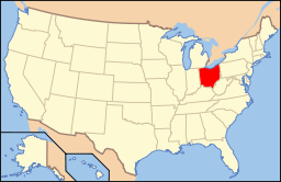
Location of Madison County in Ohio
This is a list of the National Register of Historic Places listings in Madison County, Ohio.
This is intended to be a complete list of the properties and districts on the National Register of Historic Places in Madison County, Ohio, United States. The locations of National Register properties and districts for which the latitude and longitude coordinates are included below, may be seen in a Google map.[1]
There are 11 properties and districts listed on the National Register in the county.
- This National Park Service list is complete through NPS recent listings posted December 2, 2016.[2]
Current listings
| [3] | Name on the Register[4] | Image | Date listed[5] | Location | City or town | Description |
|---|---|---|---|---|---|---|
| 1 | Cary Village Site | 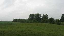 |
(#75001479) |
Amid fields around the Cary Ditch, southeast of Plain City[6] 40°04′49″N 83°14′46″W / 40.080333°N 83.246167°W |
Darby Township | |
| 2 | Farmers National Bank | 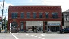 |
(#95000168) |
Southwestern corner of the junction of Main and Chillicothe Sts. 40°06′27″N 83°16′03″W / 40.1075°N 83.2675°W |
Plain City | |
| 3 | First United Methodist Church | 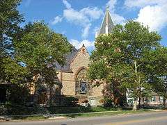 |
(#96000930) |
52 N. Main St. 39°53′14″N 83°26′59″W / 39.887222°N 83.449722°W |
London | |
| 4 | London Commercial Business Historic District |  |
(#85003212) |
Roughly bounded by Adams, Superior and Clair Sts., Madison Ave., and Huron St. 39°53′05″N 83°26′49″W / 39.884722°N 83.446944°W |
London | |
| 5 | Madison County Courthouse |  |
(#73001504) |
Public Sq. 39°53′12″N 83°26′57″W / 39.886667°N 83.449167°W |
London | |
| 6 | Mount Sterling Historic District |  |
(#74001559) |
Both sides of London St. 39°43′12″N 83°15′54″W / 39.72°N 83.265°W |
Mount Sterling | |
| 7 | Price Corners |  |
(#95000496) |
7040 U.S. Route 42 S., south of Plain City 40°02′42″N 83°17′54″W / 40.045°N 83.298333°W |
Canaan Township | |
| 8 | Red Brick Tavern |  |
(#75001478) |
1700 Cumberland Rd. in Lafayette 39°56′16″N 83°24′24″W / 39.937778°N 83.406667°W |
Deer Creek Township | |
| 9 | Skunk Hill Mounds |  |
(#74001560) |
On a ridge above the west bank of Little Darby Creek[7] 39°55′53″N 83°16′00″W / 39.931458°N 83.266667°W |
Jefferson Township | Near West Jefferson |
| 10 | Swetland House | 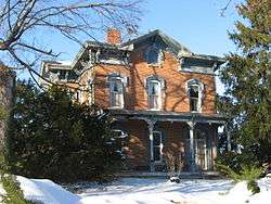 |
(#83002007) |
147 E. High St. 39°53′21″N 83°26′39″W / 39.889167°N 83.444167°W |
London | |
| 11 | Valentine Wilson House | 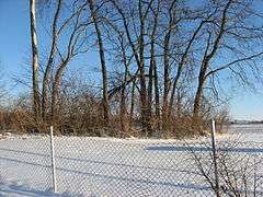 |
(#73001505) |
About 1 mile north of Summerford off Interstate 70 39°56′35″N 83°30′21″W / 39.943056°N 83.505833°W |
Somerford Township |
See also
| Wikimedia Commons has media related to National Register of Historic Places in Madison County, Ohio. |
References
- ↑ The latitude and longitude information provided in this table was derived originally from the National Register Information System, which has been found to be fairly accurate for about 99% of listings. For about 1% of NRIS original coordinates, experience has shown that one or both coordinates are typos or otherwise extremely far off; some corrections may have been made. A more subtle problem causes many locations to be off by up to 150 yards, depending on location in the country: most NRIS coordinates were derived from tracing out latitude and longitudes off of USGS topographical quadrant maps created under the North American Datum of 1927, which differs from the current, highly accurate WGS84 GPS system used by most on-line maps. Chicago is about right, but NRIS longitudes in Washington are higher by about 4.5 seconds, and are lower by about 2.0 seconds in Maine. Latitudes differ by about 1.0 second in Florida. Some locations in this table may have been corrected to current GPS standards.
- ↑ "National Register of Historic Places: Weekly List Actions". National Park Service, United States Department of the Interior. Retrieved on December 2, 2016.
- ↑ Numbers represent an ordering by significant words. Various colorings, defined here, differentiate National Historic Landmarks and historic districts from other NRHP buildings, structures, sites or objects.
- ↑ National Park Service (2008-04-24). "National Register Information System". National Register of Historic Places. National Park Service.
- ↑ The eight-digit number below each date is the number assigned to each location in the National Register Information System database, which can be viewed by clicking the number.
- ↑ Location derived from Owen, Lorrie K., ed. Dictionary of Ohio Historic Places. Vol. 1. St. Clair Shores: Somerset, 1999, 646. The NRIS lists the site as "Address Restricted".
- ↑ Location derived from Aument, Bruce Warren. Mortuary Variability in the Middle Big Darby Drainage of Central Ohio Between 300 B.C. and 300 A.D. Diss. Ohio State University. Columbus: Ohio State U, 1990, 85 and 113. Accessed 2009-11-10. The NRIS lists the site as "Address Restricted".

Municipalities and communities of Madison County, Ohio, United States | ||
|---|---|---|
| City | | |
| Villages | ||
| Townships | ||
| CDPs | ||
| Unincorporated communities | ||
| Footnotes | ‡This populated place also has portions in an adjacent county or counties | |
This article is issued from Wikipedia - version of the 1/19/2016. The text is available under the Creative Commons Attribution/Share Alike but additional terms may apply for the media files.