National Register of Historic Places listings in Coshocton County, Ohio
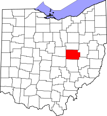
Location of Coshocton County in Ohio
This is a list of the National Register of Historic Places listings in Coshocton County, Ohio.
This is intended to be a complete list of the properties and districts on the National Register of Historic Places in Coshocton County, Ohio, United States. The locations of National Register properties and districts for which the latitude and longitude coordinates are included below, may be seen in a Google map.[1]
There are 19 properties and districts listed on the National Register in the county. Another property was once listed but has been removed.
- This National Park Service list is complete through NPS recent listings posted December 2, 2016.[2]
Current listings
| [3] |
Name on the Register[4] |
Image |
Date listed[5] |
Location |
City or town |
Description |
|---|
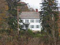
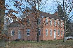
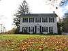
| 1 |
Adams-Gray House |
|
000000001979-12-05-0000December 5, 1979
(#79001797) |
Southeast of Trinway on Tobacco Hill Rd.
40°09′31″N 81°56′54″W / 40.158611°N 81.948333°W / 40.158611; -81.948333 (Adams-Gray House) |
Virginia Township |
Extends into Cass Township in Muskingum County
|
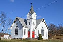
| 2 |
Chalfant Church |
|
000000001982-03-15-0000March 15, 1982
(#82004416) |
South of Warsaw off State Route 60
40°10′58″N 82°01′06″W / 40.182778°N 82.018333°W / 40.182778; -82.018333 (Chalfant Church) |
Washington Township |
|
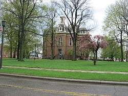
| 3 |
Coshocton County Courthouse |
|
000000001973-05-22-0000May 22, 1973
(#73001402) |
Courthouse Sq.
40°16′27″N 81°51′59″W / 40.274167°N 81.866389°W / 40.274167; -81.866389 (Coshocton County Courthouse) |
Coshocton |
|
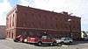
| 4 |
Eldridge-Higgins Building |
|
000000001998-08-06-0000August 6, 1998
(#98001012) |
525 Orange St.
40°16′14″N 81°51′48″W / 40.270694°N 81.863333°W / 40.270694; -81.863333 (Eldridge-Higgins Building) |
Coshocton |
|
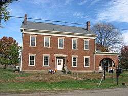
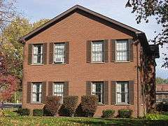
| 5 |
Andrew Ferguson House |
|
000000001978-11-30-0000November 30, 1978
(#78002028) |
East of West Lafayette on State Route 751
40°16′19″N 81°43′38″W / 40.271944°N 81.727222°W / 40.271944; -81.727222 (Andrew Ferguson House) |
Lafayette Township |
|
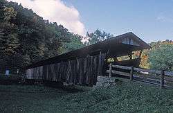
| 6 |
Helmick Covered Bridge |
|
000000001975-06-18-0000June 18, 1975
(#75001348) |
East of Blissfield on Township Road 25
40°23′35″N 81°56′34″W / 40.393056°N 81.942778°W / 40.393056; -81.942778 (Helmick Covered Bridge) |
Clark Township |
|
| 7 |
Thomas Johnson House |
|
000000001982-05-14-0000May 14, 1982
(#82004415) |
State Route 541
40°12′33″N 81°43′01″W / 40.209167°N 81.717083°W / 40.209167; -81.717083 (Thomas Johnson House) |
Plainfield |
|
| 8 |
Johnson-Humrickhouse House |
|
000000001974-10-09-0000October 9, 1974
(#74001424) |
302 S. 3rd St.
40°16′14″N 81°52′00″W / 40.270556°N 81.866667°W / 40.270556; -81.866667 (Johnson-Humrickhouse House) |
Coshocton |
|
| 9 |
Lamberson-Markley Houses |
|
000000001984-10-18-0000October 18, 1984
(#84000125) |
713 Main St. in Canal Lewisville
40°17′55″N 81°50′24″W / 40.298750°N 81.840000°W / 40.298750; -81.840000 (Lamberson-Markley Houses) |
Tuscarawas Township |
|
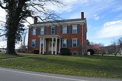
| 10 |
Samuel Lee House |
|
000000001979-12-06-0000December 6, 1979
(#79001796) |
306 4th St.
40°16′36″N 81°51′54″W / 40.276667°N 81.865°W / 40.276667; -81.865 (Samuel Lee House) |
Coshocton |
|
| 11 |
J.F. Meek Buildings |
|
000000001985-01-02-0000January 2, 1985
(#85000033) |
546 Chestnut St. and 213-215 N. 6th St.
40°16′30″N 81°51′43″W / 40.275°N 81.861944°W / 40.275; -81.861944 (J.F. Meek Buildings) |
Coshocton |
|
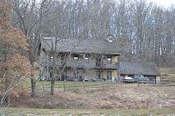
| 12 |
Daniel Miller House |
|
000000001980-01-03-0000January 3, 1980
(#80002967) |
West of West Lafayette at 52357 County Road 16
40°16′40″N 81°46′41″W / 40.277778°N 81.778056°W / 40.277778; -81.778056 (Daniel Miller House) |
Lafayette Township |
|
| 13 |
Cuthbert Milligan House |
|
000000001980-11-25-0000November 25, 1980
(#80002966) |
North of Coshocton
40°19′58″N 81°53′36″W / 40.332778°N 81.893333°W / 40.332778; -81.893333 (Cuthbert Milligan House) |
Keene Township |
|
| 14 |
Muskingum River Navigation Historic District |
|
000000002007-02-09-0000February 9, 2007
(#07000025) |
Coshocton, Muskingum, Morgan, Washington Counties
40°17′02″N 81°52′39″W / 40.283889°N 81.877500°W / 40.283889; -81.877500 (Muskingum River Navigation Historic District) |
Numerous jurisdictions |
|
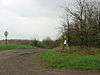
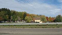
| 15 |
Eli Nichols Farm |
|
000000001982-11-29-0000November 29, 1982
(#82001364) |
Off the junction of Rabbit Ridge and Brush Run Rds., west of Walhonding[6]
40°21′16″N 82°10′59″W / 40.354444°N 82.183056°W / 40.354444; -82.183056 (Eli Nichols Farm) |
Newcastle Township |
|
| 16 |
Old Union School |
|
000000001984-10-18-0000October 18, 1984
(#84000127) |
310 Sycamore St.
40°16′41″N 81°51′59″W / 40.278056°N 81.866389°W / 40.278056; -81.866389 (Old Union School) |
Coshocton |
|
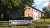
| 17 |
Roscoe Village |
|
000000001973-04-03-0000April 3, 1973
(#73001403) |
Whitewoman and High Sts.
40°16′35″N 81°52′36″W / 40.276389°N 81.876667°W / 40.276389; -81.876667 (Roscoe Village) |
Coshocton |
|
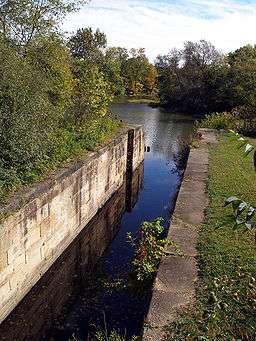
| 18 |
Walhonding Canal Lock No. 9 |
|
000000001986-02-24-0000February 24, 1986
(#86000307) |
State Route 715, west of Warsaw
40°20′42″N 82°04′33″W / 40.345°N 82.075833°W / 40.345; -82.075833 (Walhonding Canal Lock No. 9) |
Jefferson Township |
|
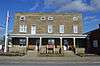
| 19 |
Warsaw Hotel |
|
000000001994-03-17-0000March 17, 1994
(#94000244) |
102 E. Main St.
40°20′08″N 82°00′23″W / 40.335556°N 82.006389°W / 40.335556; -82.006389 (Warsaw Hotel) |
Warsaw |
|
See also
References
- ↑ The latitude and longitude information provided in this table was derived originally from the National Register Information System, which has been found to be fairly accurate for about 99% of listings. For about 1% of NRIS original coordinates, experience has shown that one or both coordinates are typos or otherwise extremely far off; some corrections may have been made. A more subtle problem causes many locations to be off by up to 150 yards, depending on location in the country: most NRIS coordinates were derived from tracing out latitude and longitudes off of USGS topographical quadrant maps created under the North American Datum of 1927, which differs from the current, highly accurate WGS84 GPS system used by most on-line maps. Chicago is about right, but NRIS longitudes in Washington are higher by about 4.5 seconds, and are lower by about 2.0 seconds in Maine. Latitudes differ by about 1.0 second in Florida. Some locations in this table may have been corrected to current GPS standards.
- ↑ "National Register of Historic Places: Weekly List Actions". National Park Service, United States Department of the Interior. Retrieved on December 2, 2016.
- 1 2 Numbers represent an ordering by significant words. Various colorings, defined here, differentiate National Historic Landmarks and historic districts from other NRHP buildings, structures, sites or objects.
- ↑ National Park Service (2008-04-24). "National Register Information System". National Register of Historic Places. National Park Service.
- ↑ The eight-digit number below each date is the number assigned to each location in the National Register Information System database, which can be viewed by clicking the number.
- ↑ Location derived from 2009 Heart of Ohio Tour, Knox County Convention and Visitors Bureau, 2009. Accessed 2010-03-26. The NRIS lists the site as "Address Restricted".
|
|---|
|
Lists
by county | | |
|---|
|
| Lists by city | |
|---|
|
| Other lists | |
|---|
|
|

.jpg)