National Register of Historic Places listings in Perry County, Ohio
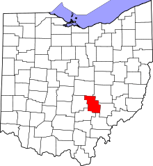
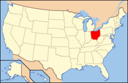
Location of Perry County in Ohio
This is a list of the National Register of Historic Places listings in Perry County, Ohio.
This is intended to be a complete list of the properties and districts on the National Register of Historic Places in Perry County, Ohio, United States. The locations of National Register properties and districts for which the latitude and longitude coordinates are included below, may be seen in a Google map.[1]
There are 13 properties and districts listed on the National Register in the county.
- This National Park Service list is complete through NPS recent listings posted December 2, 2016.[2]
Current listings
| [3] | Name on the Register[4] | Image | Date listed[5] | Location | City or town | Description |
|---|---|---|---|---|---|---|
| 1 | Bowman Mill Covered Bridge | 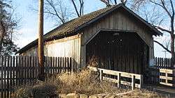 |
(#78002169) |
Perry County Fairgrounds[6] 39°43′15″N 82°13′27″W / 39.720833°N 82.224250°W |
Pike Township | Originally located south of New Reading on Winegardner Rd.;[4] moved to the fairgrounds in 1987[6] |
| 2 | Glenford Bank |  |
(#90000389) |
Main and Broad Sts. 39°53′18″N 82°19′05″W / 39.888333°N 82.318056°W |
Glenford | |
| 3 | Glenford Fort | 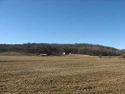 |
(#71000649) |
Along Jonathan's Creek south of Glenford[7] 39°52′30″N 82°19′00″W / 39.875000°N 82.316667°W |
Hopewell Township | |
| 4 | Randolph Mitchell House | 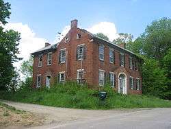 |
(#78002170) |
Rush Creek Rd. in New Reading 39°48′36″N 82°21′12″W / 39.810000°N 82.353333°W |
Reading Township | |
| 5 | New Straitsville School |  |
(#01000590) |
402 Clark St. 39°34′57″N 82°14′03″W / 39.582500°N 82.234167°W |
New Straitsville | |
| 6 | Parks Covered Bridge | 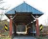 |
(#74001590) |
North of Somerset on County Road 33, south of Chalfunts 39°51′09″N 82°16′45″W / 39.852389°N 82.279167°W |
Hopewell Township | |
| 7 | Perry County Courthouse and Jail | 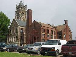 |
(#81000449) |
Main and Brown Sts. 39°42′50″N 82°12′30″W / 39.713889°N 82.208333°W |
New Lexington | |
| 8 | Saint Joseph's Catholic Church | 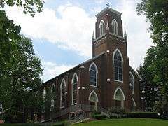 |
(#86002267) |
5757 State Route 383, southeast of Somerset 39°46′38″N 82°16′37″W / 39.777361°N 82.276944°W |
Reading Township | |
| 9 | Shawnee Historic District | 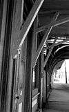 |
(#76001507) |
Both sides of Main St., 2nd St. to Walnut St. 39°36′14″N 82°12′40″W / 39.603889°N 82.211111°W |
Shawnee | |
| 10 | Sheridan House | 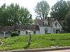 |
(#80003208) |
S. Columbus St. 39°47′57″N 82°17′32″W / 39.799167°N 82.292361°W |
Somerset | |
| 11 | Somerset Historic District | 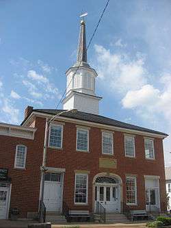 |
(#75001516) |
Main St. from High St. to properties facing Market Sq; Columbus St. from junction with Sheridan and Gay Sts. 39°48′25″N 82°18′02″W / 39.806903°N 82.300611°W |
Somerset | Includes the Old Perry County Courthouse[8] |
| 12 | West School |  |
(#80003207) |
Off State Route 93 39°46′15″N 82°06′11″W / 39.770972°N 82.103056°W |
Crooksville | |
| 13 | Soloman Whitmer House | 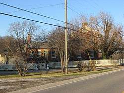 |
(#79001924) |
North of Thornville at 13917 Zion Road, NW. 39°54′08″N 82°25′04″W / 39.902361°N 82.417778°W |
Thorn Township |
See also
| Wikimedia Commons has media related to National Register of Historic Places in Perry County, Ohio. |
References
- ↑ The latitude and longitude information provided in this table was derived originally from the National Register Information System, which has been found to be fairly accurate for about 99% of listings. For about 1% of NRIS original coordinates, experience has shown that one or both coordinates are typos or otherwise extremely far off; some corrections may have been made. A more subtle problem causes many locations to be off by up to 150 yards, depending on location in the country: most NRIS coordinates were derived from tracing out latitude and longitudes off of USGS topographical quadrant maps created under the North American Datum of 1927, which differs from the current, highly accurate WGS84 GPS system used by most on-line maps. Chicago is about right, but NRIS longitudes in Washington are higher by about 4.5 seconds, and are lower by about 2.0 seconds in Maine. Latitudes differ by about 1.0 second in Florida. Some locations in this table may have been corrected to current GPS standards.
- ↑ "National Register of Historic Places: Weekly List Actions". National Park Service, United States Department of the Interior. Retrieved on December 2, 2016.
- ↑ Numbers represent an ordering by significant words. Various colorings, defined here, differentiate National Historic Landmarks and historic districts from other NRHP buildings, structures, sites or objects.
- 1 2 National Park Service (2008-04-24). "National Register Information System". National Register of Historic Places. National Park Service.
- ↑ The eight-digit number below each date is the number assigned to each location in the National Register Information System database, which can be viewed by clicking the number.
- 1 2 Tourism, Perry County Chamber of Commerce, 2013. Accessed 2013-05-16.
- ↑ Mills, William C. Archeological Atlas of Ohio. Columbus: Ohio State Archeological and Historical Society, 1914, page 64 and plate 64.
- ↑ Owen, Lorrie K., ed. Dictionary of Ohio Historic Places. Vol. 2. St. Clair Shores: Somerset, 1999, 1138.

Municipalities and communities of Perry County, Ohio, United States | ||
|---|---|---|
| Villages | | |
| Townships | ||
| CDP | ||
| Unincorporated communities | ||
| Ghost towns | ||
| Footnotes | ‡This populated place also has portions in an adjacent county or counties | |
This article is issued from Wikipedia - version of the 1/17/2016. The text is available under the Creative Commons Attribution/Share Alike but additional terms may apply for the media files.