National Register of Historic Places listings in Fairfield County, Ohio
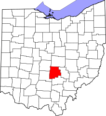
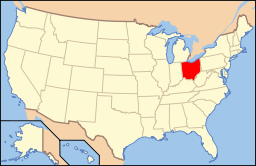
Location of Fairfield County in Ohio
This is a list of the National Register of Historic Places listings in Fairfield County, Ohio.
This is intended to be a complete list of the properties and districts on the National Register of Historic Places in Fairfield County, Ohio, United States. The locations of National Register properties and districts for which the latitude and longitude coordinates are included below, may be seen in a Google map.[1]
There are 44 properties and districts listed on the National Register in the county, including 1 National Historic Landmark. Another 3 properties were once listed but have been removed.
- This National Park Service list is complete through NPS recent listings posted December 2, 2016.[2]
Current listings
| [3] | Name on the Register[4] | Image | Date listed[5] | Location | City or town | Description |
|---|---|---|---|---|---|---|
| 1 | Lyman Allen House and Barn | 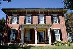 |
(#76001420) |
9930 Lancaster-Circleville Rd SW 39°41′48″N 82°47′40″W / 39.696667°N 82.794444°W |
Amanda Township | |
| 2 | John Artz Farmhouse | Upload image | (#87000644) |
5125 Duffy Rd., east of Lancaster 39°38′27″N 82°30′20″W / 39.640833°N 82.505556°W |
Berne Township | |
| 3 | Barr House | 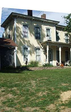 |
(#80002995) |
350 W. Main St. 39°39′04″N 82°45′04″W / 39.651111°N 82.751111°W |
Amanda | |
| 4 | John Bright Covered Bridge | 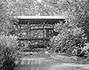 |
(#75001393) |
Spans Fetters Run on the Ohio University Lancaster campus[6] 39°44′16″N 82°35′05″W / 39.737639°N 82.584722°W |
Lancaster | Moved from its original location, 2.5 mi (4.0 km) southwest of Baltimore over Poplar Creek |
| 5 | John Bright No. 1 Iron Bridge | 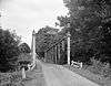 |
(#78002060) |
Spans Fetters Run on the Ohio University Lancaster campus[6] 39°44′12″N 82°35′05″W / 39.736528°N 82.584722°W |
Lancaster | Moved from its original location, 2 mi (3.2 km) northeast of Carroll on Havensport Rd. |
| 6 | Samuel Bush House | 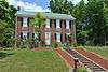 |
(#74001478) |
1934 Cold Spring Dr. 39°44′15″N 82°37′09″W / 39.7375°N 82.619167°W |
Lancaster | |
| 7 | Chestnut Ridge Farm | 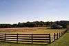 |
(#72001006) |
3375 Cincinnati-Zanesville Rd., SW., southwest of Lancaster 39°40′59″N 82°39′46″W / 39.683056°N 82.662778°W |
Hocking Township | |
| 8 | Concord Hall | Upload image | (#72001007) |
1445 Cincinnati-Zanesville Rd., SW. (U.S. Route 22), southwest of Lancaster 39°41′56″N 82°37′45″W / 39.698889°N 82.629167°W |
Hocking Township | |
| 9 | Coon Hunters Mound | Upload image | (#74001475) |
Grounds of the Central Ohio Coonhunters Association, 6995 Coonpath Rd.[7] |
Bloom Township | Near Carroll |
| 10 | Crawfis Institute | Upload image | (#79001833) |
Crawfis and Old Sugar Grove Rds., north of Sugar Grove 39°40′45″N 82°33′28″W / 39.679167°N 82.557778°W |
Berne Township | |
| 11 | Dilger Store | 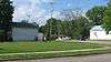 |
(#85001691) |
7640 Main St. 39°45′49″N 82°26′52″W / 39.763611°N 82.447778°W |
West Rushville | |
| 12 | J.H. Dovel Farm | 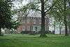 |
(#82003566) |
660 N. Hill Rd. 39°53′57″N 82°45′56″W / 39.899167°N 82.765556°W |
Pickerington | |
| 13 | Dovel-Bowers House | 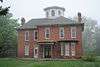 |
(#93000890) |
380 W. Columbus St. 39°53′05″N 82°45′56″W / 39.884722°N 82.765556°W |
Pickerington | |
| 14 | Ety Enclosure | Upload image | (#74001476) |
Northeast of Carroll[8] |
Greenfield Township | |
| 15 | Ety Habitation Site | Upload image | (#74001477) |
Northeast of Carroll[8] |
Greenfield Township | |
| 16 | Fairfield County Children's Home | 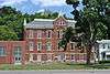 |
(#08001196) |
1743 E. Main St. 39°42′53″N 82°33′49″W / 39.714839°N 82.563589°W |
Lancaster | |
| 17 | Fortner Mounds I, II | Upload image | (#74001481) |
Northeast of Pickerington[8] |
Violet Township | |
| 18 | John Gill Farmstead | 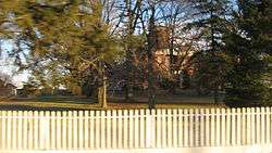 |
(#97000373) |
12310 Lancaster-Newark Rd., west of Millersport 39°54′15″N 82°33′35″W / 39.904167°N 82.559722°W |
Walnut Township | |
| 19 | Hizey Covered Bridge | 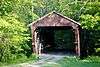 |
(#76001423) |
Private drive at 12549 Tollgate Rd.[9] 39°54′53″N 82°42′33″W / 39.9146°N 82.7092°W |
Violet Township | Moved from its original location east of Pickerington |
| 20 | Joseph Ijams House | 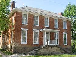 |
(#83001965) |
7660 Main St 39°45′50″N 82°26′51″W / 39.763750°N 82.447500°W |
West Rushville | |
| 21 | Lancaster Historic District |  |
(#83003438) |
Roughly bounded by 5th Ave., Penn Central railroad tracks, U.S. Route 33, and Tennant St. 39°42′49″N 82°35′54″W / 39.713611°N 82.598333°W |
Lancaster | |
| 22 | Lancaster Methodist Episcopal Camp Ground Historic District | 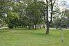 |
(#87001560) |
Roughly bounded by the Hocking River, W. Fair Ave., and Ety Rd. 39°43′43″N 82°38′18″W / 39.728611°N 82.638333°W |
Lancaster | |
| 23 | Lancaster West Main Street Historic District | 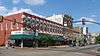 |
(#79001830) |
W. Main St. from Columbus to Broad St. 39°42′50″N 82°36′12″W / 39.713889°N 82.603333°W |
Lancaster | |
| 24 | Lockville Canal Locks | 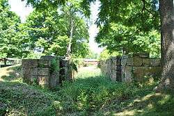 |
(#74001480) |
Off Pickerington-Lockville Rd. in Lockville 39°49′02″N 82°44′11″W / 39.817276°N 82.736343°W |
Violet Township | |
| 25 | William Medill House | 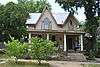 |
(#78002061) |
319 N. High St. 39°42′59″N 82°35′58″W / 39.716389°N 82.599444°W |
Lancaster | |
| 26 | Miller Farm | 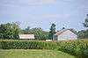 |
(#78002058) |
370 Pleasantville Rd. 39°48′56″N 82°35′18″W / 39.815556°N 82.588333°W |
Walnut Township | |
| 27 | Henry Musser House | 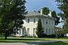 |
(#78002059) |
Southeast of Baltimore at 7079 Millersport Rd. 39°49′36″N 82°33′04″W / 39.826667°N 82.551111°W |
Walnut Township | |
| 28 | Old Maid's Orchard Mound | Upload image | (#74001479) |
In Chestnut Ridge Metro Park, near Lithopolis[10] |
Bloom Township | |
| 29 | Pickerington Carnegie Library | 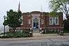 |
(#93000892) |
15 W. Columbus St. 39°53′02″N 82°45′13″W / 39.883889°N 82.753611°W |
Pickerington | |
| 30 | Pickerington Depot | 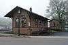 |
(#90001119) |
50 N. Center St. 39°53′07″N 82°45′15″W / 39.885278°N 82.754167°W |
Pickerington | |
| 31 | Pugh-Kittle House | 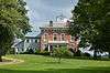 |
(#83001964) |
2140 Bickel Church Rd., northeast of Baltimore 39°52′14″N 82°32′40″W / 39.870556°N 82.544444°W |
Walnut Township | |
| 32 | Valentine Reber House | 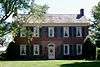 |
(#75001395) |
West of Lancaster at 8325 Lancaster-Circleville Rd. (State Route 188) 39°42′26″N 82°45′41″W / 39.707222°N 82.761389°W |
Amanda Township | |
| 33 | Rock Mill | 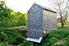 |
(#90000850) |
Rock Mill Rd. on the southern bank of the Hocking River, northwest of Lancaster 39°44′54″N 82°42′47″W / 39.748333°N 82.713056°W |
Bloom Township | |
| 34 | Rock Mill Covered Bridge | 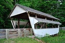 |
(#76001424) |
State Route 41 at Rock Mill 39°44′56″N 82°42′48″W / 39.748889°N 82.713333°W |
Bloom Township | |
| 35 | Royalton House | 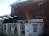 |
(#75001396) |
8691 Royalton Rd SW 39°43′33″N 82°46′02″W / 39.725833°N 82.767222°W |
Amanda Township | |
| 36 | Rushville Historic District |  |
(#80002996) |
Bremen Ave., Main and Market Sts. 39°45′51″N 82°25′51″W / 39.764167°N 82.430833°W |
Rushville | |
| 37 | St. Peter's Evangelical Lutheran Church |  |
(#79001831) |
Broad and Mullberry Sts. 39°42′59″N 82°36′06″W / 39.716389°N 82.601667°W |
Lancaster | |
| 38 | Theodore B. Schaer Mound | Upload image | (#75001394) |
Southeast of Canal Winchester[8] |
Violet Township | |
| 39 | John Sherman Birthplace |  |
(#66000609) |
137 E. Main St. 39°42′50″N 82°36′02″W / 39.71394°N 82.6005°W |
Lancaster | |
| 40 | Square 13 Historic District |  |
(#72001008) |
Roughly the area along Broad and High Sts. between Mulberry and Chestnut Sts. 39°42′52″N 82°36′02″W / 39.714444°N 82.600556°W |
Lancaster | |
| 41 | Tallmadge-Mithoff House | 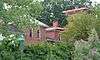 |
(#76001422) |
720 Lincoln Ave. (now Mithoff Dr.) 39°42′32″N 82°37′00″W / 39.708889°N 82.616667°W |
Lancaster | |
| 42 | Tarlton Cross Mound | 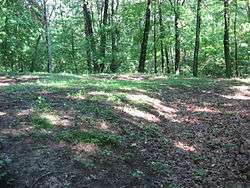 |
(#70000489) |
Tarlton State Park, northwest of Tarlton[11] 39°33′44″N 82°47′07″W / 39.5622°N 82.7853°W |
Clear Creek Township | |
| 43 | Willow Lane Farm | Upload image | (#72001009) |
Southwest of Lancaster on U.S. Route 22 39°41′34″N 82°38′42″W / 39.692778°N 82.645°W |
Hocking Township | |
| 44 | Winegardner Village | 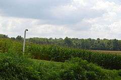 |
(#74001482) |
On a bluff above Little Rush Creek, east of the junction of Gun Barrel and Miller Siding Rds.[12] 39°47′55″N 82°26′21″W / 39.7986°N 82.4392°W |
Richland Township | Near Rushville |
Former listings
| [3] | Name on the Register | Image | Date listed | Date removed | Location | City or town | Summary |
|---|---|---|---|---|---|---|---|
| 1 | Blacklick Covered Bridge | Upload image | (#77001585) | Tussing Rd., west of State Route 256 |
Pickerington | ||
| 2 | Loucks Covered Bridge | Upload image | (#76001421) | Southeast of Canal Winchester on State Route 207 |
Canal Winchester | ||
| 3 | Stemen Road Covered Bridge | Upload image | (#79001832) | Northeast of Pickerington over Sycamore Creek |
Pickerington |
See also
| Wikimedia Commons has media related to National Register of Historic Places in Fairfield County, Ohio. |
References
- ↑ The latitude and longitude information provided in this table was derived originally from the National Register Information System, which has been found to be fairly accurate for about 99% of listings. For about 1% of NRIS original coordinates, experience has shown that one or both coordinates are typos or otherwise extremely far off; some corrections may have been made. A more subtle problem causes many locations to be off by up to 150 yards, depending on location in the country: most NRIS coordinates were derived from tracing out latitude and longitudes off of USGS topographical quadrant maps created under the North American Datum of 1927, which differs from the current, highly accurate WGS84 GPS system used by most on-line maps. Chicago is about right, but NRIS longitudes in Washington are higher by about 4.5 seconds, and are lower by about 2.0 seconds in Maine. Latitudes differ by about 1.0 second in Florida. Some locations in this table may have been corrected to current GPS standards.
- ↑ "National Register of Historic Places: Weekly List Actions". National Park Service, United States Department of the Interior. Retrieved on December 2, 2016.
- 1 2 Numbers represent an ordering by significant words. Various colorings, defined here, differentiate National Historic Landmarks and historic districts from other NRHP buildings, structures, sites or objects.
- ↑ National Park Service (2008-04-24). "National Register Information System". National Register of Historic Places. National Park Service.
- ↑ The eight-digit number below each date is the number assigned to each location in the National Register Information System database, which can be viewed by clicking the number.
- 1 2 Nevin, Mark. "OUL Historical Bridges". Ohio University Lancaster, n.d. Accessed 2015-08-19.
- ↑ Location and address derived respectively from Owen, Lorrie K., ed. Dictionary of Ohio Historic Places. Vol. 1. St. Clair Shores: Somerset, 1999, 393.; and Contact Us, Central Ohio Coonhunters Association, n.d. Accessed 2010-11-01. The NRIS lists the site as "Address Restricted".
- 1 2 3 4 Location derived from its Federal Register notice; the NRIS lists the site as "Address Restricted"
- ↑ Location derived from this ODOT webpage; the NRIS lists it at its previous location.
- ↑ Location derived from this Columbus Metro Parks webpage; the NRIS lists the site as "Address Restricted"
- ↑ Location derived from this Universities Space Research Association webpage; the NRIS lists the site as "Address Restricted"
- ↑ Location derived from Burks, Jarrod D. Identifying Household Cluster and Refuse Disposal Patterns at the Strait Site: a Third Century A. D. Nucleated Settlement in the Middle Ohio Valley. Diss. Ohio State University, 2004, 247. Accessed 2010-10-07. The NRIS lists the site as "Address Restricted".

Municipalities and communities of Fairfield County, Ohio, United States | ||
|---|---|---|
| Cities | | |
| Villages | ||
| Townships | ||
| CDPs | ||
| Unincorporated communities | ||
| Footnotes | ‡This populated place also has portions in an adjacent county or counties | |
This article is issued from Wikipedia - version of the 10/24/2016. The text is available under the Creative Commons Attribution/Share Alike but additional terms may apply for the media files.