National Register of Historic Places listings in Holmes County, Ohio
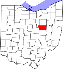
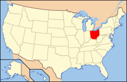
Location of Holmes County in Ohio
This is a list of the National Register of Historic Places listings in Holmes County, Ohio.
This is intended to be a complete list of the properties and districts on the National Register of Historic Places in Holmes County, Ohio, United States. The locations of National Register properties and districts for which the latitude and longitude coordinates are included below, may be seen in a Google map.[1]
There are 16 properties and districts listed on the National Register in the county.
- This National Park Service list is complete through NPS recent listings posted December 2, 2016.[2]
Current listings
| [3] |
Name on the Register[4] |
Image |
Date listed[5] |
Location |
City or town |
Description |
|---|
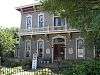
| 1 |
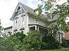
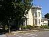
G. Adams House |
|
000000001984-07-17-0000July 17, 1984
(#84003730) |
103 N. Clay St.
40°33′21″N 81°55′03″W / 40.555833°N 81.917500°W / 40.555833; -81.917500 (G. Adams House) |
Millersburg |
|
| 2 |
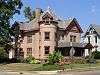
Joseph Armstrong Farm |
|
000000001978-11-27-0000November 27, 1978
(#78002088) |
Southeast of Fredericksburg
40°39′55″N 81°51′28″W / 40.665278°N 81.857778°W / 40.665278; -81.857778 (Joseph Armstrong Farm) |
Salt Creek Township |
|
| 3 |
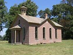
Boyd School |
|
000000001980-10-03-0000October 3, 1980
(#80003103) |
Northwest of Berlin on County Road 201 (Fryburg-Fredericksburg-Boyd Rd.)
40°34′47″N 81°49′13″W / 40.5797°N 81.8202°W / 40.5797; -81.8202 (Boyd School) |
Berlin Township |
|
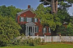
| 4 |
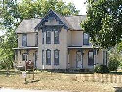
Brightman House |
|
000000001974-10-29-0000October 29, 1974
(#74001528) |
Wooster Rd. and Walnut St.
40°33′34″N 81°55′07″W / 40.559306°N 81.918611°W / 40.559306; -81.918611 (Brightman House) |
Millersburg |
|
| 5 |
G. W. Cary House |
|
000000001984-07-17-0000July 17, 1984
(#84003734) |
200 N. Washington St.
40°33′20″N 81°55′05″W / 40.555556°N 81.918056°W / 40.555556; -81.918056 (G. W. Cary House) |
Millersburg |
|
| 6 |
Hiram W. Cary House |
|
000000001984-07-17-0000July 17, 1984
(#84003736) |
101 N. Clay St.
40°33′20″N 81°55′03″W / 40.555556°N 81.9175°W / 40.555556; -81.9175 (Hiram W. Cary House) |
Millersburg |
|
| 7 |
Croco House |
|
000000001985-06-20-0000June 20, 1985
(#85001343) |
State Route 83, north of Holmesville
40°38′10″N 81°55′38″W / 40.636111°N 81.927222°W / 40.636111; -81.927222 (Croco House) |
Prairie Township |
|
| 8 |
Joseph L. DeYarmon House |
|
000000001982-05-04-0000May 4, 1982
(#82003599) |
Southwestern corner of County Road 179 and Township Road 464, southwest of Lakeville
40°39′10″N 82°08′10″W / 40.652778°N 82.136111°W / 40.652778; -82.136111 (Joseph L. DeYarmon House) |
Washington Township |
|
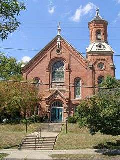
| 9 |
Disciple-Christian Church |
|
000000001984-07-17-0000July 17, 1984
(#84003738) |
100 N. Clay St.
40°33′20″N 81°55′01″W / 40.555556°N 81.916944°W / 40.555556; -81.916944 (Disciple-Christian Church) |
Millersburg |
|
| 10 |
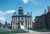
Holmes County Courthouse and Jail |
|
000000001974-07-25-0000July 25, 1974
(#74001529) |
Courthouse Sq.
40°33′14″N 81°55′02″W / 40.553889°N 81.917222°W / 40.553889; -81.917222 (Holmes County Courthouse and Jail) |
Millersburg |
|
| 11 |
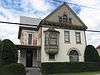
John E. Koch, Jr. House |
|
000000001984-07-17-0000July 17, 1984
(#84003740) |
107 N. Washington St.
40°33′23″N 81°55′07″W / 40.556250°N 81.918611°W / 40.556250; -81.918611 (John E. Koch, Jr. House) |
Millersburg |
|
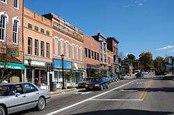
| 12 |
Millersburg Historic District |
|
000000001984-07-17-0000July 17, 1984
(#84003743) |
Jackson, Clay, and Washington Sts.
40°33′15″N 81°55′05″W / 40.554167°N 81.918056°W / 40.554167; -81.918056 (Millersburg Historic District) |
Millersburg |
|
| 13 |
Pomerene House |
|
000000001980-10-20-0000October 20, 1980
(#80003102) |
U.S. Route 62 in Berlin
40°33′41″N 81°47′42″W / 40.561389°N 81.795°W / 40.561389; -81.795 (Pomerene House) |
Berlin Township |
|
| 14 |
Shull-Lugenbuhl Farm |
|
000000001979-04-26-0000April 26, 1979
(#79001866) |
North of Winesburg
40°38′04″N 81°41′47″W / 40.634444°N 81.696389°W / 40.634444; -81.696389 (Shull-Lugenbuhl Farm) |
Paint Township |
|
| 15 |
United Methodist Church |
|
000000001984-07-17-0000July 17, 1984
(#84003744) |
N. Washington St.
40°33′21″N 81°55′08″W / 40.555833°N 81.918889°W / 40.555833; -81.918889 (United Methodist Church) |
Millersburg |
|
| 16 |
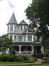
Peter Wise House |
Upload image |
000000001980-04-16-0000April 16, 1980
(#80003104) |
South of Berlin on State Route 557
40°31′52″N 81°48′36″W / 40.531111°N 81.81°W / 40.531111; -81.81 (Peter Wise House) |
Berlin Township |
Dismantled in 2008 and pieces scattered among various locations[6] |
See also
References
- ↑ The latitude and longitude information provided in this table was derived originally from the National Register Information System, which has been found to be fairly accurate for about 99% of listings. For about 1% of NRIS original coordinates, experience has shown that one or both coordinates are typos or otherwise extremely far off; some corrections may have been made. A more subtle problem causes many locations to be off by up to 150 yards, depending on location in the country: most NRIS coordinates were derived from tracing out latitude and longitudes off of USGS topographical quadrant maps created under the North American Datum of 1927, which differs from the current, highly accurate WGS84 GPS system used by most on-line maps. Chicago is about right, but NRIS longitudes in Washington are higher by about 4.5 seconds, and are lower by about 2.0 seconds in Maine. Latitudes differ by about 1.0 second in Florida. Some locations in this table may have been corrected to current GPS standards.
- ↑ "National Register of Historic Places: Weekly List Actions". National Park Service, United States Department of the Interior. Retrieved on December 2, 2016.
- ↑ Numbers represent an ordering by significant words. Various colorings, defined here, differentiate National Historic Landmarks and historic districts from other NRHP buildings, structures, sites or objects.
- ↑ National Park Service (2008-04-24). "National Register Information System". National Register of Historic Places. National Park Service.
- ↑ The eight-digit number below each date is the number assigned to each location in the National Register Information System database, which can be viewed by clicking the number.
- ↑ Baker, Jon. "A Greek Revival", The Times-Reporter, 2008-05-25. Accessed 2015-01-21.
|
|---|
|
Lists
by county | | |
|---|
|
| Lists by city | |
|---|
|
| Other lists | |
|---|
|
|