Travis County, Texas
| Travis County, Texas | ||
|---|---|---|
|
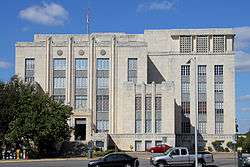
Heman Marion Sweatt Travis County Courthouse in Austin | ||
| ||
 Location in the U.S. state of Texas | ||
 Texas's location in the U.S. | ||
| Founded | 1840 | |
| Named for | William B. Travis | |
| Seat | Austin | |
| Largest city | Austin | |
| Area | ||
| • Total | 1,023 sq mi (2,650 km2) | |
| • Land | 990 sq mi (2,564 km2) | |
| • Water | 33 sq mi (85 km2), 3.2% | |
| Population (est.) | ||
| • (2014) | 1,151,145 | |
| • Density | 1,163/sq mi (449/km²) | |
| Congressional districts | 10th, 17th, 21st, 25th, 35th | |
| Time zone | Central: UTC-6/-5 | |
| Website |
traviscountytx | |

Coordinates: 30.33°0′N 97.78°0′W / 30.330°N 97.780°W
Travis County is a county located in south central Texas. As of the 2010 census, the population was 1,024,266; the estimated population in 2014 was 1,151,145.[1] It is the fifth-most populous county in Texas. Its county seat is Austin,[2] the capital of Texas. The county was established in 1840 and is named in honor of William Barret Travis, the commander of the Republic of Texas forces at the Battle of the Alamo.
Travis County is part of the Austin-Round Rock Metropolitan Statistical Area. It is located along the Balcones Fault, the boundary between the Edwards Plateau to the west and the Blackland Prairie to the east.
History
Pre-Columbian and colonial periods
Evidence of habitation of the Balcones Escarpment region of Texas can be traced to at least 11,000 years ago. Two of the oldest Paleolithic archeological sites in Texas, the Levi Rock Shelter and Smith Rock Shelter, are located in southwest and southeast Travis County, respectively.[3] Several hundred years before the arrival of European settlers, the area was inhabited by a variety of nomadic Native American tribes. These indigenous peoples fished and hunted along the creeks, including present-day Barton Springs,[4] which proved to be a reliable campsite.[5] At the time of the first permanent settlement of the area, the Tonkawa tribe was the most common, with the Comanches and Lipan Apaches also frequenting the area.[6]
The region (along with all of modern Texas) was claimed by the Spanish Empire in the 1600s, but at the time no attempt was made to settle the area (or even to fully explore it).[7] In 1691 Domingo Terán de los Ríos made an inspection tour through East Texas that likely took him through Travis Country. The first European settlers in the area were a group of Spanish friars who arrived from East Texas in July 1730. They established three temporary missions, La Purísima Concepción, San Francisco de los Neches and San José de los Nazonis, on a site by the Colorado River near Barton Springs. The friars found conditions undesirable and relocated to the San Antonio River within a year of their arrival.[8]
Mexican period
In 1821 Mexico won its independence from Spain, and the new government enacted laws encouraging colonists to settle the Texas frontier by granting them land and reduced taxation. Over the next decade, thousands of foreign immigrants (primarily from the United States) moved into Texas; in particular, American empresario Stephen F. Austin established one of his colonies near what is now Bastrop, Texas (in future Travis County) in 1827.[9] Josiah and Mathias Wilbarger, Reuben Hornsby, Jacob M. Harrell, and John F. Webber were early settlers who moved into the area in the early 1830s.
Republican period
In 1836 Texas declared and won its independence from Mexico, forming a new Republic of Texas. After Texas Vice President Mirabeau B. Lamar visited central Texas during a buffalo-hunting expedition between 1837 and 1838, he proposed that the republic's capital (then located in Houston) be relocated to a site on the north bank of the Colorado River. In 1839 the site was officially chosen as the republic's new capital and given the name Waterloo, Texas; shortly thereafter the city's name was changed to Austin in honor of Stephen F. Austin.[10] A new county was also established the following year, of which Austin would be the seat; the county was named Travis County, after William B. Travis. Though the Republic's capital moved briefly back to Houston during the events surrounding the Texas Archive War, by 1845 Austin was again the capital, and it became the capital of the new State of Texas when Texas was annexed by the United States later that year.
Civil War and beyond
In 1861 Travis County was one of the few Texas counties to vote against secession from the Union. Since the majority of the state did favor secession, Travis County then became a part of the Confederacy for the duration of the Civil War. After the Confederacy's defeat, Texas was fully readmitted to the Union in 1870.
From the end of the Civil War to the early twenty-first century, Travis County has experienced steady, rapid population growth (averaging more than a 36% increase every decade from 1870 to 2010), driven largely by the growth of Austin and its suburbs; it is now the fifth most populous county in Texas, after Harris (Houston), Dallas, Tarrant (Fort Worth) and Bexar (San Antonio) counties.
Geography

According to the U.S. Census Bureau, the county has a total area of 1,023 square miles (2,650 km2), of which 990 square miles (2,600 km2) is land and 33 square miles (85 km2) (3.2%) is water.[11] Travis County is located in the southern part of central Texas, between San Antonio and Dallas–Fort Worth. The county's geographical center lies two miles northwest of downtown Austin at 30°18' north latitude and 97°45' west longitude.[12]
Travis County straddles the Balcones Fault, the boundary between the Edwards Plateau to the west and the Texas Coastal Plain to the east. The western part of the county is characterized by the karst topography of the Texas Hill Country, while the eastern part exhibits the fertile plains and farmlands of the Blackland Prairie. The Colorado River meanders through the county from west to east, forming a series of man-made lakes (Lake Travis, Lake Austin, and Lady Bird Lake).
Springs
The limestone karst geology of the western and southwestern parts of Travis County gives rise to numerous caverns and springs, some of which have provided shelter and water for humans in the region for thousands of years. Notable springs in the county include Barton Springs, Deep Eddy and Hamilton Pool.
Major highways
Travis County is crossed by Interstate Highway 35, US Highways 183 and 290, and Texas Highway 71. IH-35 leads northward to Waco and Dallas–Fort Worth and southward to San Antonio. US-183 leads northward through Cedar Park to Lampasas and southward to Lockhart. US-290 leads westward to Fredericksburg and eastward to Houston. TX-71 leads westward to Marble Falls and eastward to Bastrop.
Other major highways within the county include Texas Highway Loop 1 (the "Mopac Expressway"), which runs from north to south through the center of the county, and Texas Highway 45, which forms parts of an incomplete highway loop around Austin. Texas Highway 130 (constructed as an alternative to IH-35 for long-distance traffic wishing to avoid Austin and San Antonio) also runs from north to south through the sparsely populated eastern part of the county.
Adjacent counties
- Williamson County (north)
- Bastrop County (east)
- Caldwell County (south)
- Hays County (southwest)
- Blanco County (west)
- Burnet County (northwest)
Protected areas
Demographics
| Historical population | |||
|---|---|---|---|
| Census | Pop. | %± | |
| 1850 | 3,138 | — | |
| 1860 | 8,080 | 157.5% | |
| 1870 | 13,153 | 62.8% | |
| 1880 | 27,028 | 105.5% | |
| 1890 | 36,322 | 34.4% | |
| 1900 | 47,386 | 30.5% | |
| 1910 | 55,620 | 17.4% | |
| 1920 | 57,616 | 3.6% | |
| 1930 | 77,777 | 35.0% | |
| 1940 | 111,053 | 42.8% | |
| 1950 | 160,980 | 45.0% | |
| 1960 | 212,136 | 31.8% | |
| 1970 | 295,516 | 39.3% | |
| 1980 | 419,573 | 42.0% | |
| 1990 | 576,407 | 37.4% | |
| 2000 | 812,280 | 40.9% | |
| 2010 | 1,024,266 | 26.1% | |
| Est. 2015 | 1,176,558 | [13] | 14.9% |
| U.S. Decennial Census[14] 1850–2010[15] 2010–2014[1] | |||
According to the census of 2010, there were 1,024,266 people, 320,766 households, and 183,798 families residing in the county. The population density was 1034 persons per square mile (387/km²). There were 335,881 housing units at an average density of 340 per square mile (131/km²). The racial makeup of the county was 68.21% White, 9.26% Black or African American, 0.58% Native American, 4.47% Asian, 0.07% Pacific Islander, 14.56% other races, and 2.85% from two or more races. 28.20% of the population were Hispanic or Latino of any race. 12.0% were of German, 7.7% English, 6.6% Irish and 5.5% American ancestry according to Census 2000. English is the sole language spoken at home by 71.42% of the population age 5 or over, while 22.35% speak Spanish, and a Chinese language (including Mandarin, Taiwanese, and Cantonese) is spoken by 1.05%.[16]
In 2000 there were 320,766 households, of which 29.30% had children under the age of 18 living with them, 42.60% were married couples living together, 10.40% had a female householder with no husband present, and 42.70% were non-families. 30.10% of all households were composed of individuals and 4.40% had someone living alone who was 65 or older. The average household size was 2.47 and the average family size was 3.15. As of the 2010 census, there were about 11.1 same-sex couples per 1,000 households in the county.[17]
The population's age distribution was 23.80% under the age of 18, 14.70% from 18 to 24, 36.50% from 25 to 44, 18.20% from 45 to 64, and 6.70% age 65 years of age or older. The median age was 30 years. For every 100 females there were 104.90 males. For every 100 females age 18 and over, there were 104.50 males.
Government and infrastructure

Like other Texas counties, Travis County is governed by a Commissioners' Court composed of the county judge and four county commissioners. The court levies county taxes and sets the budgets for county officials and agencies. The judge and commissioners are elected for four-year terms (the judge at-large, and the commissioners from geographic precincts).
The other major county-wide official is the county clerk, who maintains the county's records, administers elections, and oversees legal documentation (such as property deeds, marriage licenses and assumed name certificates). The clerk is also elected at-large for a four-year term.
Corrections
The Travis County Jail and the Travis County Criminal Justice Center are located in Downtown Austin.[18][19] The Travis County Correctional Complex is located in an unincorporated area in Travis County, next to Austin-Bergstrom International Airport.[20]
The Texas Department of Criminal Justice operates the Travis County Unit, a state jail for men, in eastern Austin.[21]
Economy

As of 2013, Travis County had a median household income of $58,025 per year, and a per capita income of $33,206 per year. 17.4% of the population lived below the poverty level.[1] The county's largest employers are governments (the State of Texas, the US Federal Government, Travis County and the City of Austin) and public education bodies . Other major employers are concentrated in industries relating to semiconductors, software engineering and healthcare.[22]
Travis County, along with other Texas counties, has one of the nation's highest property tax rates. In 2009, the county was ranked 88th in the nation for property taxes as percentage of the homes value on owner occupied housing.[23] Travis County also ranked in the top 100 for amount of property taxes paid and for percentage of income paid as tax. Property tax rates are generally high in Texas because the state does not levy an income tax.
Education
School districts
Travis county is served by a number of public school districts; the largest is Austin Independent School District, serving most of Austin. Other districts wholly or mainly located in Travis County include Eanes ISD, Lake Travis ISD, Lago Vista ISD, Leander ISD, Del Valle ISD, Manor ISD, and Pflugerville ISD. Parts of Elgin ISD, Coupland ISD, Round Rock ISD, Marble Falls ISD, Johnson City ISD, Dripping Springs ISD and Hays Consolidated ISD also cross into Travis County.
Colleges and universities
The largest university in Travis County is the University of Texas at Austin. Other universities include St. Edward's University, Huston–Tillotson University, and Concordia University Texas. The region's major community college system is Austin Community College District.
Culture

Within Texas, Travis County is known as an exceptionally culturally "liberal" region and a stronghold of the Texas Democratic Party.[24] The county voted for the Democratic candidate in six of the most recent seven US Presidential elections (and its one vote for a Republican was for George W. Bush, the sitting Texas Governor). Few county-wide elected positions are even contested by Republican candidates.[25] In 2005 it was the only county in Texas to vote against the Proposition 2 state constitutional amendment banning gay marriage.
Politics
| Year | Republican | Democratic |
|---|---|---|
| 2016 | 27.4% 126,750 | 66.3% 306,475 |
| 2012 | 36.2% 140,152 | 60.1% 232,788 |
| 2008 | 34.3% 136,981 | 63.5% 254,017 |
| 2004 | 42.0% 147,885 | 56.0% 197,235 |
| 2000 | 46.9% 141,235 | 41.7% 125,526 |
| 1996 | 40.0% 98,454 | 52.4% 128,970 |
| 1992 | 31.9% 88,105 | 47.3% 130,546 |
| 1988 | 44.9% 105,915 | 54.1% 127,783 |
| 1984 | 56.8% 124,944 | 42.8% 94,124 |
| 1980 | 45.7% 73,151 | 46.9% 75,028 |
| 1976 | 46.7% 71,031 | 51.6% 78,585 |
| 1972 | 56.3% 70,561 | 43.2% 54,157 |
| 1968 | 41.6% 34,309 | 48.1% 39,667 |
| 1964 | 31.0% 19,838 | 68.9% 44,058 |
| 1960 | 44.9% 22,107 | 54.9% 27,022 |
Travis County is a strongly Democratic county, having voted for the Democratic presidential nominee in twelve of the last fifteen elections since 1960.
Communities
Cities (multiple counties)
- Austin (county seat) (small parts in Hays and Williamson counties)
- Cedar Park (mostly in Williamson County)
- Elgin (mostly in Bastrop County)
- Leander (mostly in Williamson County)
- Mustang Ridge (small parts in Caldwell and Bastrop counties)
- Pflugerville (small parts in Williamson County)
- Round Rock (mostly in Williamson County)
Cities
Villages
Census-designated places
Unincorporated communities
See also
- Austin Bat Cave (non-profit educational org)
- List of museums in Central Texas
- National Register of Historic Places listings in Travis County, Texas
References
- 1 2 3 "Travis County QuickFacts". United States Census Bureau. Retrieved 18 April 2015.
- ↑ "Find a County". National Association of Counties. Retrieved 2011-06-07.
- ↑ Hester, Thomas (1986). "The Balcones Escarpment: Early Human Populations". Geological Society of America. Abbott, Patrick L. and Woodruff, C. M. 6 (2): 55–62. Retrieved September 6, 2011.
- ↑ Brief History of Austin from Austin History Center
- ↑ History of Barton Springs from Austin History Center
- ↑ Native Americans in Austin from Austin History Center
- ↑ Chipman, Donald E. (1992), Spanish Texas, 1519–1821, Austin, Texas: University of Texas Press, p. 26, ISBN 0-292-77659-4
- ↑ "The Spanish Missions in Texas". Texas Almanac. Texas State Historical Association. Retrieved September 10, 2011.
- ↑ de la Teja, Jesus F. (1997). "The Colonization and Independence of Texas: A Tejano Perspective". In Rodriguez O., Jaime E.; Vincent, Kathryn. Myths, Misdeeds, and Misunderstandings: The Roots of Conflict in U.S.–Mexican Relations. Wilmington, DE: Scholarly Resources Inc. p. 88. ISBN 0-8420-2662-2.
- ↑ City of Austin - Austin History Center: Waterloo
- ↑ "2010 Census Gazetteer Files". United States Census Bureau. August 22, 2012. Retrieved May 11, 2015.
- ↑ Smyrl, Vivian Elizabeth (15 June 2010). "TRAVIS COUNTY". Handbook of Texas Online. Texas State Historical Association. Retrieved 18 April 2015.
- ↑ "County Totals Dataset: Population, Population Change and Estimated Components of Population Change: April 1, 2010 to July 1, 2015". Retrieved July 2, 2016.
- ↑ "U.S. Decennial Census". United States Census Bureau. Retrieved May 11, 2015.
- ↑ "Texas Almanac: Population History of Counties from 1850–2010" (PDF). Texas Almanac. Retrieved May 11, 2015.
- ↑ "Language Map Data Center". Mla.org. 2013-04-03. Retrieved 2013-07-10.
- ↑ Where Same-Sex Couples Live, June 26, 2015, retrieved July 6, 2015
- ↑ "Travis County Jail (TCJ)." Travis County Sheriff's Office. Accessed September 14, 2008.
- ↑ "Criminal Justice Center (CJC)." Travis County Sheriff's Office. Accessed September 14, 2008.
- ↑ "Travis County Correctional Complex (TCCC)." Travis County Sheriff's Office. Accessed September 14, 2008.
- ↑ "Travis County (TI)." Texas Department of Criminal Justice. Accessed September 14, 2008.
- ↑ "Major Employers". Austin Chamber of Commerce. Retrieved 20 April 2015.
- ↑ "Property Taxes on Owner-Occupied Housing by County, 2005 - 2009, Ranked by Taxes as Percentage of Home Value (One year averages)". Tax Foundation. 2010-09-28. Retrieved 2013-07-10.
- ↑ Garrett, Robert T. (1 March 2015). "Texas GOP looks to cut influence of heavily Democratic Travis County's judges". The Dallas Morning News. Retrieved 20 April 2015.
- ↑ Owen, Sue (30 January 2014). "Only 3 Republicans in 19 Travis County races". PolitiFact. Retrieved 20 April 2015.
- ↑ http://uselectionatlas.org/
External links
- Travis County Government website
- Travis County from the Handbook of Texas Online
- Travis County Law Library
- Travis County, Texas at DMOZ
 |
Burnet County | Williamson County | | |
| Blanco County | |
Bastrop County | ||
| ||||
| | ||||
| Hays County | Caldwell County |
Municipalities and communities of Travis County, Texas, United States | ||
|---|---|---|
| Cities | | |
| Villages | ||
| CDPs | ||
| Other unincorporated communities | ||
| Footnotes | ‡This populated place also has portions in an adjacent county or counties | |
| Central city | 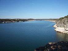 | ||||||
|---|---|---|---|---|---|---|---|
| Satellite cities | |||||||
| Other communities | |||||||
| Counties |
| ||||||
| Parks and preserves |
| ||||||
| Geography | |||||||
| Bodies of water | |||||||
| Transportation | |||||||
