Wheeler County, Texas
| Wheeler County, Texas | |
|---|---|
|
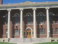
Wheeler County Courthouse | |
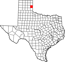 Location in the U.S. state of Texas | |
 Texas's location in the U.S. | |
| Founded | 1879 |
| Seat | Wheeler |
| Largest city | Shamrock |
| Area | |
| • Total | 915 sq mi (2,370 km2) |
| • Land | 915 sq mi (2,370 km2) |
| • Water | 1.0 sq mi (3 km2), 0.1% |
| Population | |
| • (2010) | 5,410 |
| • Density | 5.9/sq mi (2/km²) |
| Congressional district | 13th |
| Time zone | Central: UTC-6/-5 |
| Website |
www |


Wheeler County is a county located in the U.S. state of Texas. As of the 2010 census, its population was 5,410.[1] Its county seat is Wheeler.[2] The county was formed in 1876 and organized in 1879.[3] It is named for Royall Tyler Wheeler, a chief justice of the Texas Supreme Court.
Wheeler County was one of thirty[4] prohibition or entirely dry counties in the state of Texas. However, in approximately 2010, the community of Shamrock, located in Wheeler County at the intersection of Interstate 40 (old U.S. Route 66) and U.S. Highway 83, voted to allow liquor sales. Within the city limits of Shamrock is the only place to purchase liquor in Wheeler County.
History
In 1876, the Texas State Legislature established Wheeler County. In 1879, Mobeetie was named the county seat. Mobeetie was then known as "Sweetwater," but this name should not be confused with the Sweetwater, which is the seat of Nolan County west of Abilene. A stone courthouse was erected from locally quarried materials in 1880 but was replaced by a wooden structure in 1888. The town of Wheeler was designated as the county seat in 1908. The wooden courthouse was moved to the current site but was replaced by the existing structure as a result of a 1925 bond election. The previous building was sold to a sheriff, Riley Price, who dismantled it and used it to build barns on his nearby ranch. The structure was designed by E. H. Eads of Shamrock and built by local contractors Hughes and Campbell. It features Palladian windows and Corinthian columns, characteristic of the Greek revival style of architecture.[5]
In the 1880s, Temple Lea Houston, the youngest son of Sam Houston, was the district attorney of the 35th Judicial District of Texas, when then encompassed twenty-six counties in the Texas Panhandle. The district was based at the time in the courthouse at Mobeetie in Wheeler County. Houston was also a member of the Texas State Senate from 1885 to 1889 and later moved to Oklahoma, where he worked for statehood. An NBC television series, Temple Houston, which aired from 1963 to 1964, is loosely based on his life, with Jeffrey Hunter in the starring role.[6]
The Pioneer West Museum, the Wheeler County historical museum, is located in Shamrock off U.S. Highway 83.
Geography
According to the U.S. Census Bureau, the county has a total area of 915 square miles (2,370 km2), of which 915 square miles (2,370 km2) is land and 1.0 square mile (2.6 km2) (0.1%) is water.[7]
Major highways
U.S. Highway 66 is no longer officially commissioned or signed, but has special brown historic signage at various points along its former routing.
Adjacent counties
- Hemphill County (north)
- Roger Mills County, Oklahoma (northeast)
- Beckham County, Oklahoma (east)
- Collingsworth County (south)
- Gray County (west)
- Donley County (southwest)
- Roberts County (northwest)
Demographics
| Historical population | |||
|---|---|---|---|
| Census | Pop. | %± | |
| 1880 | 512 | — | |
| 1890 | 778 | 52.0% | |
| 1900 | 636 | −18.3% | |
| 1910 | 5,258 | 726.7% | |
| 1920 | 7,397 | 40.7% | |
| 1930 | 15,555 | 110.3% | |
| 1940 | 12,411 | −20.2% | |
| 1950 | 10,317 | −16.9% | |
| 1960 | 7,947 | −23.0% | |
| 1970 | 6,434 | −19.0% | |
| 1980 | 7,137 | 10.9% | |
| 1990 | 5,879 | −17.6% | |
| 2000 | 5,284 | −10.1% | |
| 2010 | 5,410 | 2.4% | |
| Est. 2015 | 5,657 | [8] | 4.6% |
| U.S. Decennial Census[9] 1850–2010[10] 2010–2014[1] | |||
As of the census[11] of 2000, there were 5,284 people, 2,152 households, and 1,487 families residing in the county. The population density was 6 people per square mile (2/km²). There were 2,687 housing units at an average density of 3 per square mile (1/km²). The racial makeup of the county was 87.83% White, 2.78% Black or African American, 0.78% Native American, 0.55% Asian, 0.08% Pacific Islander, 6.64% from other races, and 1.34% from two or more races. 12.57% of the population were Hispanic or Latino of any race.
There were 2,152 households out of which 29.60% had children under the age of 18 living with them, 58.00% were married couples living together, 7.70% had a female householder with no husband present, and 30.90% were non-families. 29.10% of all households were made up of individuals and 16.90% had someone living alone who was 65 years of age or older. The average household size was 2.39 and the average family size was 2.94.
In the county, the population was spread out with 24.90% under the age of 18, 6.50% from 18 to 24, 22.50% from 25 to 44, 25.20% from 45 to 64, and 20.90% who were 65 years of age or older. The median age was 42 years. For every 100 females there were 92.00 males. For every 100 females age 18 and over, there were 87.40 males.
The median income for a household in the county was $31,029, and the median income for a family was $36,989. Males had a median income of $26,790 versus $19,091 for females. The per capita income for the county was $16,083. About 11.60% of families and 13.00% of the population were below the poverty line, including 13.30% of those under age 18 and 16.80% of those age 65 or over.
Politics
Republican Drew Springer, Jr., a businessman from Muenster in Cooke County, has since January 2013 represented Wheeler County in the Texas House of Representatives.[12]
The representative from 1971 to 1979 was the Democrat Phil Cates, later a lobbyist in Austin.[13]
Communities
Cities
Unincorporated communities
See also
- List of museums in the Texas Panhandle
- National Register of Historic Places listings in Wheeler County, Texas
References
- 1 2 "State & County QuickFacts". United States Census Bureau. Retrieved December 29, 2013.
- ↑ "Find a County". National Association of Counties. Retrieved 2011-06-07.
- ↑ "Texas: Individual County Chronologies". Texas Atlas of Historical County Boundaries. The Newberry Library. 2008. Retrieved May 27, 2015.
- ↑ http://www.tabc.state.tx.us/local_option_elections/index.asp
- ↑ Texas Historical Commission, historical marker, Wheeler, Texas
- ↑ Billy Hathorn, "Roy Bean, Temple Houston, Bill Longley, Ranald Mackenzie, Buffalo Bill, Jr., and the Texas Rangers: Depictions of West Texans in Series Television, 1955 to 1967", West Texas Historical Review, Vol. 89 (2013), pp. 106-109
- ↑ "2010 Census Gazetteer Files". United States Census Bureau. August 22, 2012. Retrieved May 12, 2015.
- ↑ "County Totals Dataset: Population, Population Change and Estimated Components of Population Change: April 1, 2010 to July 1, 2015". Retrieved July 2, 2016.
- ↑ "U.S. Decennial Census". United States Census Bureau. Retrieved May 12, 2015.
- ↑ "Texas Almanac: Population History of Counties from 1850–2010" (PDF). Texas Almanac. Retrieved May 12, 2015.
- ↑ "American FactFinder". United States Census Bureau. Retrieved 2011-05-14.
- ↑ "State Rep. Springer announces district tour July 30". Lubbock Avalanche-Journal, July 16, 2013. Retrieved July 18, 2013.
- ↑ "Phil Cates". Texas Legislative Reference Library. Retrieved June 29, 2015.
External links
- Wheeler County Official Website
- Wheeler County from the Handbook of Texas Online
- Wheeler County Profile from the Texas Association of Counties
- Entry for Royal T. Wheeler from the Biographical Encyclopedia of Texas published 1880, hosted by the Portal to Texas History.
- Historic Wheeler County materials, hosted by the Portal to Texas History.
 |
Hemphill County | Roger Mills County, Oklahoma | | |
| Gray County | |
Beckham County, Oklahoma | ||
| ||||
| | ||||
| Collingsworth County |
Municipalities and communities of Wheeler County, Texas, United States | ||
|---|---|---|
| Cities | | |
| Unincorporated communities | ||

Coordinates: 35°24′N 100°16′W / 35.40°N 100.27°W