South Kingstown, Rhode Island
| South Kingstown, Rhode Island | |
|---|---|
| Town | |
| Town of South Kingstown | |
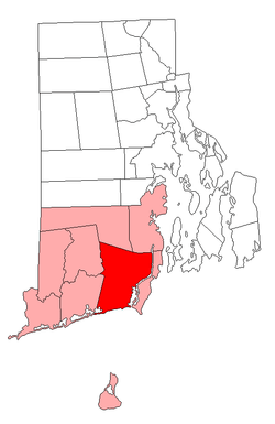 Location of South Kingstown in Washington County, Rhode Island | |
| Coordinates: 41°26′51″N 71°31′38″W / 41.44750°N 71.52722°WCoordinates: 41°26′51″N 71°31′38″W / 41.44750°N 71.52722°W | |
| Country | United States |
| State | Rhode Island |
| County | Washington |
| Incorporated | 1723[1] |
| Government | |
| • Town Council |
Abel G. Collins (President)[2] Rachel Clough Liz Gledhill Joe Viele |
| • Town Manager | Stephen A. Alfred[3] |
| Area | |
| • Total | 79.8 sq mi (206.6 km2) |
| • Land | 57.1 sq mi (147.9 km2) |
| • Water | 22.7 sq mi (58.7 km2) |
| Elevation | 98 ft (30 m) |
| Population (2010) | |
| • Total | 30,639 inhabitants |
| • Density | 536.6/sq mi (207.2/km2) |
| Time zone | Eastern (EST) (UTC-5) |
| • Summer (DST) | EDT (UTC-4) |
| ZIP codes | 02874 (Saunderstown), 02879 (Wakefield), 02881 (Kingston), 02883 (Peace Dale), 02892 (West Kingston) |
| Area code(s) | 401 |
| FIPS code | 44-67460[4] |
| GNIS feature ID | 1220090[5] |
| Website | http://www.southkingstownri.com |
South Kingstown is a town in Washington County, Rhode Island, United States. The population was 30,639 at the 2010 census. South Kingstown is the largest town in Washington County and is the largest town (land and water area) in the state of Rhode Island.
History
The town of South Kingstown was formed in 1722 when the former Kings Towne was split into two parts, the other being North Kingstown. South Kingstown was incorporated in 1723.[1] In 1888 a narrow strip of land running along the eastern bank of the Pettaquamscutt River to the shore of Narragansett Bay was separated from South Kingstown to form the town of Narragansett.
Geography
South Kingstown includes the villages of Kingston, West Kingston, Wakefield, Peace Dale, Usquepaug, Snug Harbor, Tuckertown, East Matunuck, Matunuck, Green Hill, and Perryville. Peace Dale and Wakefield are treated as a census-designated place called Wakefield-Peacedale. Ocean Ridge, Indian Lake, Curtis Corner, and Torrey Hill are among the other small areas that are regarded as unique localities, although official distinctions are less clear. Middlebridge, located on the west side of Narrow River, is a densely populated neighborhood in the town.
Adjacent towns
- Charlestown, Rhode Island-west
- Exeter, Rhode Island-north
- Narragansett, Rhode Island-east
- North Kingstown, Rhode Island-north
- Richmond, Rhode Island-west
South Kingstown is bordered to the south by the Atlantic Ocean.
Demographics
| Historical population | |||
|---|---|---|---|
| Census | Pop. | %± | |
| 1790 | 4,131 | — | |
| 1800 | 3,438 | −16.8% | |
| 1810 | 3,560 | 3.5% | |
| 1820 | 3,723 | 4.6% | |
| 1830 | 3,663 | −1.6% | |
| 1840 | 3,717 | 1.5% | |
| 1850 | 3,807 | 2.4% | |
| 1860 | 4,717 | 23.9% | |
| 1870 | 4,493 | −4.7% | |
| 1880 | 5,114 | 13.8% | |
| 1890 | 4,823 | −5.7% | |
| 1900 | 4,972 | 3.1% | |
| 1910 | 5,176 | 4.1% | |
| 1920 | 5,181 | 0.1% | |
| 1930 | 6,010 | 16.0% | |
| 1940 | 7,282 | 21.2% | |
| 1950 | 10,148 | 39.4% | |
| 1960 | 11,942 | 17.7% | |
| 1970 | 16,913 | 41.6% | |
| 1980 | 20,414 | 20.7% | |
| 1990 | 24,631 | 20.7% | |
| 2000 | 27,921 | 13.4% | |
| 2010 | 30,639 | 9.7% | |
| Est. 2015 | 30,826 | [6] | 0.6% |
Arts and culture
Art galleries include the Hera Gallery (Wakefield), South County Art Association (Kingston), and sometimes the Courthouse Center for the Arts (or CCA, West Kingston). Theaters include The Contemporary Theatre (Wakefield), the Theatre-by-the-Sea (Matunuck), and the CCA. The sole cinema is South County Cinema 8 (Wakefield), which replaced the independently run Campus Cinema (Wakefield) in the early 2000s. There are numerous venues for music and other entertainment, including the University of Rhode Island's Ryan Center and smaller venues such as Lily Pads (Peace Dale), and the CCA.
Arts and cultural education is also offered through community centers like The Guild and the Senior Center in Wakefield. There are also three public libraries which are located in Kingston, Matunuck, and Peace Dale.
Athletics
The Ocean State Waves of the historic New England Collegiate Baseball League play their home games at Old Mountain Field located at 875 Kingstown Rd.
Museums
The South County History Center, located in the village of Kingston, is located in a former jail building and contains a collection of fine Early American artifacts.
Points of interest
South Kingstown is the location of the deadly Great Swamp Fight that occurred during King Philip's War in 1675. The battle site is commemorated by a rough granite shaft about twenty feet high. Around the mound on which the shaft stands are four granite markers engraved with the names of the colonies which took part in the battle.[8] South Kingstown is home to 31 sites listed on the National Register of Historic Places, 4 of which are historic districts. A driving tour is described by the Pettaquamscutt Historical Society.[9]
- Kingston Village Historic District, located in the village of Kingston
- Peace Dale Historic District, located in the village of Peace Dale
- Usquepaug Road Historic District, located near the village of Usquepaug
- Wakefield Historic District, located in the village of Wakefield
Government
South Kingstown was previously governed by town meetings, like many other New England towns, until recently when it switched to a council-manager government in an attempt to keep order to the government of a town with about 30,000 residents.
All 5 seats on the Town Council are at-large seats that are up for election every 2 years, with no term limits. After each election, the newly elected Council members elect two of their own as President and Vice President. Quite often (but not always, and not currently), these are the two highest vote-getters in the previous election. The current President is Abel G. Collins (I), and the current Vice President is Margaret M. 'Meg' Healy (D).
The town's citizens also elect a 7-member School Committee. Committee members are elected to staggered 4-year terms, with 4 seats typically up for election in U.S. Presidential election years and the other 3 typically up for election in midterm election years. The current Chair is Raissa Mosher (D) and the current Vice Chair is Maureen Cotter (D).
Parks and recreation
South Kingstown has over ten miles of undisturbed beaches.[10]
Law enforcement
Municipal
Law enforcement within the Town of South Kingstown is maintained by the South Kingstown Police Department, located in the village of Peace Dale. The Chief of Police is Chief Vincent Vespia, Jr.
State
 The Rhode Island State Police Wickford Barracks, located in the Town of North Kingstown, has jurisdiction.
Education
South Kingstown is served by the South Kingstown School District. The district includes nine schools that serve students in grades prekindergarten to twelfth. .[11][12]
Pre-kindergarten (Pre-K)
- South Kingstown Inclusionary Pre-School, located in the village of Wakefield
Elementary schools
- Matunuck Elementary School, located in the village of Matunuck
- Peace Dale Elementary School, located in the village of Peace Dale
- Wakefield Elementary School, located in the village of Wakefield
- West Kingston Elementary School, located in the village of West Kingston
Middle schools
- Broad Rock Middle School, located in the village of Wakefield
- Curtis Corner Middle School, located in the village of Wakefield
High schools
- Independence Transition Academy, located in the village of Kingston
- South Kingstown High School, located in the village of Wakefield
Colleges and universities
The University of Rhode Island is located in the village of Kingston.[13]
Private schools
- The Compass School, a charter school located in the village of Kingston
- Monsignor Clarke School, a K-8 Catholic school located in the village of Wakefield
- The Prout School, a Catholic high school located in the village of Wakefield
Health and medicine
South County Hospital is located in the village of Wakefield.
Infrastructure
Transportation
Roads
![]() U.S. Route 1 is a 2369 mile long U.S. Numbered Highway with 12.3 miles passing through the southern and eastern portions of the Town of South Kingstown. It is a divided highway and is split into 2 sections within the town. It enters South Kingstown's southwest at its border with Town of Charlestown and runs northeasterly for 7.7 miles to the town's border with the Town of Narragansett. The route continues again from Narragansett and runs north for a distance 4.6 miles to the town's border with the Town of North Kingstown, running concurrently with Route 138 for the last 0.3 miles. Along its route it intersects with Route 1A, Route 108, Route 110, and Route 138.
U.S. Route 1 is a 2369 mile long U.S. Numbered Highway with 12.3 miles passing through the southern and eastern portions of the Town of South Kingstown. It is a divided highway and is split into 2 sections within the town. It enters South Kingstown's southwest at its border with Town of Charlestown and runs northeasterly for 7.7 miles to the town's border with the Town of Narragansett. The route continues again from Narragansett and runs north for a distance 4.6 miles to the town's border with the Town of North Kingstown, running concurrently with Route 138 for the last 0.3 miles. Along its route it intersects with Route 1A, Route 108, Route 110, and Route 138.
From the town's border with Charlestown to the intersection with Route 108, the highway is known as the Commodore Oliver Hazard Perry Highway. From the intersection with Route 108 to the town's border with North Kingstown, the highway is known as Tower Hill Road.
![]() Route 1A is a 39.6 mile long state highway with 8.6 miles running through the Town of South Kingstown. For most of its route, it parallels U.S. Route 1 and can be divided into roughly 4 distinct sections.
Route 1A is a 39.6 mile long state highway with 8.6 miles running through the Town of South Kingstown. For most of its route, it parallels U.S. Route 1 and can be divided into roughly 4 distinct sections.
The route enters South Kingstown from the southwestern at its border with the Town of Charlestown and travels through the village of Green Hill for 0.9 miles before intersecting with U.S. Route 1. This section of the route is known as Post Road. After a brief run on U.S. Route 1 North, a U-Turn is required to intersect with continue onto Route 1A. The second section begins from this intersection and runs 2.1 miles to its second intersection with U.S. Route 1 traveling through the village of Perryville. Along the route it intersects with Route 110. This section of the route is known as Post Road. After a brief run on U.S. Route 1 North, an exit to Route 1A is provided. The third section begins from the exit, it runs 1.15 miles running parallel to and eventually intersecting again with U.S. Route 1. This section of the route is known as Post Road. After a brief run on U.S. Route 1 North, a U-Turn is required to intersect with continue onto Route 1A. From this intersection, the fourth section runs for 2 miles to the routes intersection with Route 108. From there, the route turns right to run concurrently with Route 108 for 0.5 miles until the town's border with the Town of Narragansett. This section runs through the village of Wakefield. This section of the route from U.S. Route 1 to its intersection with South Road is known as Post Road. From its intersection with South Road to its intersection with Route 108 it is known as Main Street. Along its concurrency with Route 108 it is known as Kingstown Road.
![]() Route 2 is a 36 mile long state highway with 9.6 miles running through the Town of South Kingstown. The route enters South Kingstown at its border with the Town of Richmond and runs north to the town’s border with the Town of Exeter. Along its route, Route 2 intersects with Route 138. For its entire route in South Kingstown, it is known as South County Trail.
Route 2 is a 36 mile long state highway with 9.6 miles running through the Town of South Kingstown. The route enters South Kingstown at its border with the Town of Richmond and runs north to the town’s border with the Town of Exeter. Along its route, Route 2 intersects with Route 138. For its entire route in South Kingstown, it is known as South County Trail.
![]() Route 108 is an 8.6 mile long state highway with 4 miles running through the Town of South Kingstown. The route begins at its northern terminus in the village of Kingston at its intersection with Route 138 and runs south to the town's border with the Town of Narragansett, running concurrently with Route 1A for the last 0.5 miles. It is a major local route between the University of Rhode Island and the beaches of Narragansett and along the route passes through the villages of Peace Dale and Wakefield. For the entire route through South Kingstown, it is known as Kingstown Road.
Route 108 is an 8.6 mile long state highway with 4 miles running through the Town of South Kingstown. The route begins at its northern terminus in the village of Kingston at its intersection with Route 138 and runs south to the town's border with the Town of Narragansett, running concurrently with Route 1A for the last 0.5 miles. It is a major local route between the University of Rhode Island and the beaches of Narragansett and along the route passes through the villages of Peace Dale and Wakefield. For the entire route through South Kingstown, it is known as Kingstown Road.
![]() Route 110 is a 6.1 mile long state highway running entirely within the Town of South Kingstown. Its northern terminus is with State Route 138 in the village of Kingston and its southern terminus is with U.S Route 1 in the village of Perryville. For the entire route through South Kingstown, it is known as Ministerial Road. A granite marker at the corner of Curtis Corner Road commemorates the grant of 300 acres (120 ha) for income to the ministry.
Route 110 is a 6.1 mile long state highway running entirely within the Town of South Kingstown. Its northern terminus is with State Route 138 in the village of Kingston and its southern terminus is with U.S Route 1 in the village of Perryville. For the entire route through South Kingstown, it is known as Ministerial Road. A granite marker at the corner of Curtis Corner Road commemorates the grant of 300 acres (120 ha) for income to the ministry.
![]() Route 138 is a 45.2 mile long state highway with 8.9 miles running through the Town of South Kingstown. The route enters South Kingstown from the west at its border with the Town of Richmond, traveling 8.6 miles until it intersects with U.S. Route 1 where the route turns to the north to run concurrently with U.S. Route 1 for its last 0.3 miles, exiting the town at its border with the Town of North Kingstown. Along its route, Route 138 intersects with Route 2, Route 110, Route 108, and U.S. Route 1 and passes through the villages of Usquepaug, West Kingston, and Kingston. Route 138 is a major road connecting the South Kingstown and its tenant University of Rhode Island with Interstate 95 and the Narragansett Bay communities of Jamestown, and Newport. It is also the primary route to the historic Kingston Station, a stop along Amtrak's Northeast Corridor. The section of Route 138 from the border with Richmond to its intersection with Route 108 is known as Kingstown Road. From its intersection of Route 108 to its intersection with U.S. Route 1, it is known as Mooresfield Road. For its concurrency with U.S. Route 1, it is known as Tower Hill Road.
Route 138 is a 45.2 mile long state highway with 8.9 miles running through the Town of South Kingstown. The route enters South Kingstown from the west at its border with the Town of Richmond, traveling 8.6 miles until it intersects with U.S. Route 1 where the route turns to the north to run concurrently with U.S. Route 1 for its last 0.3 miles, exiting the town at its border with the Town of North Kingstown. Along its route, Route 138 intersects with Route 2, Route 110, Route 108, and U.S. Route 1 and passes through the villages of Usquepaug, West Kingston, and Kingston. Route 138 is a major road connecting the South Kingstown and its tenant University of Rhode Island with Interstate 95 and the Narragansett Bay communities of Jamestown, and Newport. It is also the primary route to the historic Kingston Station, a stop along Amtrak's Northeast Corridor. The section of Route 138 from the border with Richmond to its intersection with Route 108 is known as Kingstown Road. From its intersection of Route 108 to its intersection with U.S. Route 1, it is known as Mooresfield Road. For its concurrency with U.S. Route 1, it is known as Tower Hill Road.
Rail
![]() Rail service is provide by Amtrak via Kingston Station, which is located in the village of West Kingston. Kingston is a stop along Amtrak's Northeast Corridor and is serviced by their Northeast Regional train service. The Northeast Regional has a northern terminus with Boston's South Station with a major stop en route in Providence, and has a southern terminus with Washington's Union Station with major stops en route in New Haven, New York City, Philadelphia, Wilmington, and Baltimore.
Rail service is provide by Amtrak via Kingston Station, which is located in the village of West Kingston. Kingston is a stop along Amtrak's Northeast Corridor and is serviced by their Northeast Regional train service. The Northeast Regional has a northern terminus with Boston's South Station with a major stop en route in Providence, and has a southern terminus with Washington's Union Station with major stops en route in New Haven, New York City, Philadelphia, Wilmington, and Baltimore.
Public transportation
![]() Public transportation in South Kingstown is provided by the statewide Rhode Island Public Transit Authority or RIPTA. The following routes service South Kingstown:
Public transportation in South Kingstown is provided by the statewide Rhode Island Public Transit Authority or RIPTA. The following routes service South Kingstown:
Utilities
Electricity
Electricity services are provided by National Grid plc.
Telephone
Local and long distance landline telephone services are provided by Verizon New England.
Notable people
- Kate French, actress, lived in South Kingstown as a child
- Jhumpa Lahiri, author; raised in South Kingstown[14]
- Nathaniel Niles, United States Representative from Vermont; born in South Kingstown[15]
- Oliver Hazard Perry, United States Navy Commodore; born in South Kingstown[16]
- Erika Van Pelt, finished tenth place on American Idol (season 11); grew up in South Kingstown[17]
- Robert Tiernan, U.S. Congressman and member of the Rhode Island General Assembly[18]
- Michael Woodmansee, child murderer[19]
References
- 1 2 "South Kingstown Rhode Island". City-Data.com. Retrieved October 22, 2012.
- ↑ http://www.southkingstownri.com/town-government/town-council
- ↑ http://www.southkingstownri.com/town-government/municipal-departments/town-manager
- ↑ "American FactFinder". United States Census Bureau. Retrieved 2008-01-31.
- ↑ "US Board on Geographic Names". United States Geological Survey. 2007-10-25. Retrieved 2008-01-31.
- ↑ "Annual Estimates of the Resident Population for Incorporated Places: April 1, 2010 to July 1, 2015". Retrieved July 2, 2016.
- ↑ "Census of Population and Housing". Census.gov. Retrieved June 4, 2016.
- ↑ "The great swamp fight". Retrieved 31 October 2015.
- ↑ Pettaquamscutt Historical Society. "Scenic and Historic Driving Tour of South Kingstown". pettaquamscutt.org. Retrieved 31 October 2015.
- ↑ "Town of South Kingstown Rhode Island". Town of South Kingstown Rhode Island. Retrieved October 22, 2012.
- ↑ "South Kingstown School District". South Kingstown School District. Retrieved October 22, 2012.
- ↑ "South Kingstown School District". education.com. Retrieved October 22, 2012.
- ↑ "The University of Rhode Island". The University of Rhode Island. Retrieved October 22, 2012.
- ↑ "Jhumpa Lahiri". Emory University. Retrieved October 22, 2012.
- ↑ "Niles, Nathaniel (1741-1828)". The Political Graveyard. Retrieved October 22, 2012.
- ↑ "Oliver Hazard Perry". Find A Grave. Retrieved October 22, 2012.
- ↑ "Erika Van Pelt". American Idol. Retrieved October 22, 2012.
- ↑ "TIERNAN, Robert Owens, (1929 - )". Biographical Directory of the United States Congress. Retrieved April 21, 2014.
- ↑ "Woodmansee Talk Stirs Up Lost Memories". Time. Retrieved April 21, 2014.
External links
| Wikimedia Commons has media related to South Kingstown, Rhode Island. |
| Wikivoyage has a travel guide for South Kingstown. |
- Town of South Kingstown, Rhode Island
- South Kingstown School District
- City-Data.com
- ePodunk: Profile for South Kingstown Rhode Island
Providence (capital) | |
| Topics |
|
| Society |
|
| Regions | |
| Cities | |
| Towns |
|