Tacloban
| Tacloban | ||
|---|---|---|
| Highly Urbanized City | ||
| City of Tacloban | ||
|
Downtown Tacloban | ||
| ||
|
Nickname(s): Gateway to Eastern Visayas Queen City of the Orient Seas City of Hope | ||
| Motto: City of Love, Beauty and Progress | ||
 Map of Eastern Visayas with Tacloban highlighted | ||
.svg.png) Tacloban Location within the Philippines | ||
| Coordinates: 11°14′N 125°00′E / 11.24°N 125°ECoordinates: 11°14′N 125°00′E / 11.24°N 125°E | ||
| Country | Philippines | |
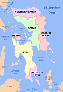
| Region | Eastern Visayas (Region VIII) | |
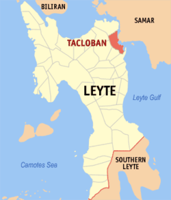
| Province | Leyte (geographically only) | |
| Established Provincial capital[1] Chartered city Highly urbanized city[2] |
1770 26 February 1830 12 June 1953 18 December 2008 | |
| Barangay | 138 (see § Barangays) | |
| Government[3] | ||
| • Type | Sangguniang Panlungsod | |
| • Mayor | Cristina Romualdez (NP) | |
| • Vice mayor | Sambo Yaokasin | |
| • City Council |
Members
| |
| Area[4] | ||
| • Total | 201.72 km2 (77.88 sq mi) | |
| Highest elevation | 21 m (69 ft) | |
| Lowest elevation | 2 m (7 ft) | |
| Population (2015 census)[5] | ||
| • Total | 242,089 | |
| • Density | 1,200/km2 (3,100/sq mi) | |
| • Voter (2013)[6] | 109,027, 124,777 | |
| Demonym(s) | Taclobanon | |
| Time zone | PHT (UTC+8) | |
| ZIP Code | 6500 | |
| IDD : area code | +63 (0)53 | |
| Income class | 1st class | |
| PSGC | 083747000 | |
| Website |
www | |
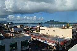
Tacloban (/tækˈloʊbən/ tak-LOH-ban; Waray: Syudad han Tacloban; Filipino: Lungsod ng Tacloban, Tagalog pronunciation: [tɐkˈloban]) is a 1st city income class highly urbanized city in the Philippines and the provincial capital of Leyte where it is geographically situated but governed administratively independent from it. It is 360 miles (580 km) southeast from Manila. According to the 2015 census, it has a population of 242,089 and is the most populous city in the Eastern Visayas region.[5] In the 2013 election, it had 109,027, 124,777 registered voters.[6]
It is also the regional center of Eastern Visayas, being the main gateway by air to the region. Tacloban was briefly the capital of the Philippines, from 20 October 1944 to 27 February 1945.
In an extensive survey conducted by the Asian Institute of Management Policy Center and released in July 2010, Tacloban ranks as the fifth most competitive city in the Philippines, and second in the emerging cities category.[7]
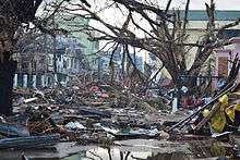
On 8 November 2013, the city was largely destroyed by Typhoon Haiyan, having previously suffered similar destruction and loss of life in 1897 and 1912.[8]
On 17 January 2015, Pope Francis visited Tacloban during his Papal Visit in the Philippines and held a mass at Barangay San Jose, and later he led mass of 30,000 people in front of the airport.
History

Tacloban was first known as Kankabatok, an allusion to the first inhabitants – Kabatok. They established their dwellings in the vicinity of the present day Santo Niño Church. Others who came later were Gumoda, Haraging and Huraw who erected their own settlements in nearby sites. Huraw's domain is the hill where the city hall now sits. The combined settlements acquired the name Kankabatok, meaning Kabatok's property.
By the end of the 16th century, Kankabatok was under the political administration of Palo and part of the parish of Basey, Samar. It was discovered in 1770, by the Augustinian Mission, who were superseded by the Franciscans in 1813. During this period, Kankabatok was renamed to Tacloban.
The change of the name came about in this manner: Kankabatok was a favorite haunt of fishermen. They would use a bamboo contraption called a "taklub" to catch crabs, shrimps or fish. When asked where they were going, the fishermen would answer, "(to) tarakluban", which meant the place where they used the device to catch these marine resources. Eventually, the name Tarakluban or Tacloban took prominence.
It is not known when Tacloban became a municipality because records supporting this fact were destroyed during a typhoon. It is commonly believed that Tacloban was officially proclaimed a municipality in 1770. In 1768, Leyte and Samar were separated into two provinces, each constituting a politico-military province. Due to its strategic location, Tacloban became a vital trading point between the two provinces.
The capital of Leyte was transferred from one town to another with Tacloban as the last on 26 February 1830. The decision to make Tacloban the capital was based on the following reasons: 1) ideal location of the port and 2) well-sheltered and adequate facilities. On 20 June 1952, Tacloban was proclaimed a chartered city by virtue of Republic Act No. 760.[1]

The arrival of Colonel Murray in 1901 made him the first military governor of Leyte. His first official act was the opening of Tacloban port to world commerce. Before World War II, Tacloban was the commercial, education, social and cultural center of the Province of Leyte. Copra and abaca were exported in large quantities. The leading institutions were: Leyte Normal School, Leyte High School, Leyte Trade School, Holy Infant Academy and Tacloban Catholic Institute.
In November 1912, a typhoon swept through the central Philippines and "practically destroyed" Tacloban. In Tacloban and Capiz on the island of Panay, the death toll was 15,000, half the population of those cities at the time.[9]
On 25 May 1942, Japanese forces landed in Tacloban, signalling the beginning of their two-year occupation of Leyte. They fortified the city and improved its airfield. Since San Pedro Bay was ideal for larger vessels, the Japanese Imperial Naval Forces made Tacloban a port of call and entry. This time was considered the darkest in the history of Tacloban and the country due to the incidences of torture among civilians, including the elderly. In response, guerrilla groups operated in Leyte – the most notable of which was the group of Ruperto Kangleon.
Leyte was the first to be liberated by the combined Filipino and American troops. General Douglas MacArthur's assault troops landed in the Tacloban and Palo beaches (White Beach and Red Beach, respectively) and in the neighboring town of Dulag (Blue Beach) on 20 October 1944. These landings signaled the eventual victory of the Filipino and American forces and the fulfillment of MacArthur’s famous promise: "I Shall Return."
Three days later, on 23 October, at a ceremony at the Capitol Building in Tacloban, MacArthur, accompanied by President Sergio Osmeña, made Tacloban the temporary seat of the Commonwealth Government and temporary capital of the Philippines until the complete liberation of the country. The provincial government of Leyte and the municipal government of Tacloban were re-established.
Paulo Jaro was the Liberation mayor of Tacloban. The first mayor of this capital upon inauguration of the Philippine Republic was Epifanio Aguirre.
On 8 January 1960 MacArthur made his "sentimental" journey to Leyte.
The city was proclaimed as a highly urbanized city by President Gloria Macapagal Arroyo on 4 October 2008[10] and ratified by the people on 18 December 2008.[11]
2013 Typhoon Haiyan
On 8 November 2013 (PST), Tacloban was hit by the full force of Typhoon Haiyan, causing massive destruction across the city. Dead bodies were scattered on the streets, trees were uprooted, and a 13 ft (4 m) storm surge largely destroyed the airport, though it functioned soon after as a makeshift command and evacuation center.[12] After taking a helicopter flight over the city, US Marine Brigadier General Paul Kennedy was quoted as saying, "I don't believe there is a single structure that is not destroyed or severely damaged in some way – every single building, every single house."[13] Widespread looting and violence is reported to have taken place[14] and local government virtually collapsed, as many city officials were victims.[15] President Aquino declared a state of emergency in Tacloban. The official final death toll stood at 6,201.[16]
2015 Papal Visit
On 17 January 2015, Pope Francis, the leader of the Roman Catholic Church, arrived in Tacloban to celebrate mass with the survivors of Haiyan (Yolanda).
Geography
Tacloban is located on Cancabato Bay, in the San Juanico Strait, which divides the islands of Leyte and Samar.
Climate
Tacloban has a tropical rainforest climate (Köppen: Af), also known as an equatorial climate, usually (but not always) found along the equator. Tropical rainforest climate is a type of tropical climate in which there is no dry season – all months have mean precipitation values of at least 60 millimetres (2.4 in). Tropical rainforest climates have no pronounced summer or winter; it is typically hot and wet throughout the year and rainfall is both heavy and frequent. One day in an equatorial climate can be very similar to the next, while the change in temperature between day and night may be larger than the average change in temperature between "summer" and "winter".
The average high (daytime) temperature for the year in Tacloban is 29.4 °C (84.9 °F). The warmest month on average is May with an average daytime temperature of 31 °C (87.8 °F). The coolest month on average is January, with an average (nighttime) temperature of 23 °C (73.4 °F).
The highest recorded temperature was 41.1 °C (106.0 °F), recorded in December. The lowest recorded temperature in Tacloban is 12.8 °C (55.0 °F) which was also recorded in December.
The average rainfall for the year is 2,294 millimetres (90.3 in), with the most rainfall on average in December with 305 millimetres (12.0 in) and the least on average in April with 119 millimetres (4.7 in).
| Climate data for Tacloban City | |||||||||||||
|---|---|---|---|---|---|---|---|---|---|---|---|---|---|
| Month | Jan | Feb | Mar | Apr | May | Jun | Jul | Aug | Sep | Oct | Nov | Dec | Year |
| Record high °C (°F) | 37 (99) |
35 (95) |
40 (104) |
40 (104) |
39 (102) |
38 (100) |
38 (100) |
38 (100) |
39 (102) |
38 (100) |
37 (99) |
41 (106) |
41 (106) |
| Average high °C (°F) | 27 (81) |
28 (82) |
29 (84) |
30 (86) |
31 (88) |
30 (86) |
30 (86) |
31 (88) |
30 (86) |
30 (86) |
29 (84) |
28 (82) |
29.4 (84.9) |
| Average low °C (°F) | 23 (73) |
23 (73) |
23 (73) |
25 (77) |
25 (77) |
25 (77) |
25 (77) |
25 (77) |
25 (77) |
25 (77) |
24 (75) |
23 (73) |
24.3 (75.5) |
| Record low °C (°F) | 16 (61) |
19 (66) |
20 (68) |
20 (68) |
21 (70) |
21 (70) |
16 (61) |
20 (68) |
20 (68) |
21 (70) |
16 (61) |
12 (54) |
12 (54) |
| Average precipitation mm (inches) | 280 (11.02) |
210 (8.27) |
150 (5.91) |
120 (4.72) |
150 (5.91) |
160 (6.3) |
160 (6.3) |
120 (4.72) |
140 (5.51) |
200 (7.87) |
280 (11.02) |
330 (12.99) |
2,300 (90.54) |
| Average rainfall mm (inches) | 281.7 (11.091) |
204.1 (8.035) |
139.6 (5.496) |
118.9 (4.681) |
142.4 (5.606) |
160.8 (6.331) |
167.0 (6.575) |
135.5 (5.335) |
161.5 (6.358) |
197.2 (7.764) |
279.0 (10.984) |
305.3 (12.02) |
2,293 (90.276) |
| Average rainy days | 20 | 17 | 15 | 14 | 14 | 16 | 16 | 14 | 16 | 19 | 20 | 21 | 202 |
| Average relative humidity (%) | 85 | 84 | 82 | 81 | 82 | 82 | 82 | 81 | 82 | 84 | 86 | 86 | 83.1 |
| Source: weatherbase | |||||||||||||
Demographics
| Population census of Tacloban | ||
|---|---|---|
| Year | Pop. | ±% p.a. |
| 1990 | 136,891 | — |
| 1995 | 167,310 | +3.83% |
| 2000 | 178,639 | +1.41% |
| 2007 | 217,199 | +2.73% |
| 2010 | 221,174 | +0.66% |
| 2015 | 242,089 | +1.74% |
| Source: National Statistics Office[5][17][18] | ||
According to the 2015 census, Tacloban has a population of 242,089 inhabitants. In the 2013 election, it had 109,027, 124,777 registered voters, meaning that Expression error: Unexpected number.% of the population are aged 18 and over.[6]
Tacloban is predominantly a Waray-speaking city. The language is also officially called Lineyte-Samarnon ("Leyte-Samarnon") and spoken by more than 90% of the total city population. Waray-Waray, aside from being the native language of the city, is also the lingua franca used in the city among Filipinos of various ethnic groups.
Tacloban is culturally and linguistically diverse. A decade before the end of Spanish sovereignty, it was largely a typical colonial community: most of its residents were either pure Iberian families or the new generations of Spanish-Filipino blood. Today's population consists of a mix of Spanish and Chinese mestizos, foreign expatriates and native Leyteños.
Other Filipino ethnic groups who migrated in the city are Cebuano/Kana/Visayan speaking populace accounts 6.08% of the total population, 0.80% are Tagalog, 0.10% are Ilocano, 0.07% are Kapampangan while 2.95% come from other ethnic origins.
88.52% of the residents of Tacloban City are Roman Catholic; 6.12% are Muslims (most are Maranao migrants from Mindanao); 0.83% are of the indigenous Christian denomination, Iglesia ni Cristo; 0.94% are Evangelicals (born-again Christians); Baptists 0.80%; 0.49% Seventh Day Adventists. Others comprise 3.10%.
Economy

Tacloban is the economic center of Eastern Visayas, with an economy largely focused on commerce, tourism, trade, education, culture, and government in the region. Several regional broadcasters are based in the city, including ABS-CBN TV-2 Tacloban and its regional newscast, TV Patrol Tacloban.
Economically, Tacloban is one of the fastest growing cities in the Philippines. It has one of the lowest poverty incidence rates in the country (at roughly 9%, while the national poverty incidence stands at 30%), and is the richest local government unit in Eastern Visayas.
After its massive devastation on 8 November 2013, Tacloban is now considered as a 'start up' city, which means everything has to start back from scratch. Currently the city is experiencing a rapid economic bounce back, and is dubbed as the 'rising phoenix of the East' surviving its challenges that once made the city classified into "ground zero". The Daniel Z. Romualdez Airport also makes this city a key regional transportation hub.
In the mid-90s, Tacloban City worked out the acquisition of 237 hectares (590 acres) for its Economic Zone, which was finally realized and approved by the Philippine Economic Zone Authority, by virtue of Presidential Proclamation No. 1210 on 23 April 1998. The Eastern Visayas Agri-Industrial Growth Center (EVRGC) was then officially registered as an Eco-Zone with the City Government of Tacloban as the developer/operator.
Transportation
Tacloban is served by air, multicabs, taxis, jeepneys, buses, tricycles and pedicabs. The airport has had plans (for many years) to upgrade to an international airport. At present, the airport is served by four airlines that offer domestic flights to and from Cebu and Manila, and the New Transport Terminal of Tacloban City or New Bus Terminal
Barangays
The City of Tacloban is divided into 138 barangays, each having its own council.
Only some of the barangays have individual names. These include the following:
- Abucay (91)
- Anibong (66, 66-A, 67, and 68)
- Apitong (92)
- Bagacay (93)
- Basper (94A)
- Baybay (89A)
- Cabalawan (97)
- Caibaan (95 & 95A)
- Calanipawan (96)
- Camansinay (98)
- Diit (99)
- El Reposo (55 & 56)
- Fatima Village (75, 76, 77)
- GE Palanog (12)
- Libertad (1 & 4)
- Lower Nulatula (74)
- Magallanes (52 & 54)
- Marasbaras (78, 79, 80, 81, 82)
- Naga-naga (71)
- New Kawayan (101)
- Nula-tula (3 & 3A)
- Old Kawayan (102)
- Palanog (103, 37A)
- PHHC (72 Seaside & 73 Mountainside)
- Sagkahan Picas (59 & 62B)
- Sagkahan Bliss (62)
- Sagkahan Saging (62A)
- Sagkahan Mangga (63)
- Sagkahan Pleasantville (63)
- Sagkahan Mahayahay (63)
- Salvacion (104)
- San Jose (83, 83A, 83C, 84, 85, 86, 87, 88, 89, 90)
- San Paglaum (103A)
- San Roque, Scandinavian subd. (100)
- Santo. Niño (106)
- Santo. Nino- GMA (106-A)
- Sta. Elena (107)
- Suhi (105)
- T. Claudio St. (5)
- Tagapuro (108)
- Tigbao (94)
- Utap (110)
- V&G Subdivision (109 & 109A)
Society
Healthcare
As the regional center of Eastern Visayas, Tacloban offers a range of healthcare services. There are a number of hospitals and other medical institutions serving the city's population.
- Public hospitals
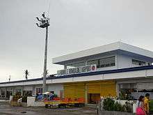
- Eastern Visayas Regional Medical Center (EVRMC)
- Tacloban City Hospital
- New Eastern Visayas Regional Medical Center (Under Construction)
- Private hospitals
- Bethany Hospital (owned by the United Church of Christ in the Philippines)
- Divine Word Hospital (owned by the Benedictine Sisters)
- Our Mother of Mercy Hospital (owned by the Religious Sisters of Mercy)
- Remedios Trinidad Romualdez Hospital (owned by the RTR Medical Foundation)
- Tacloban Doctors Medical Center (owned by a group of prominent doctors)
- ACE Medical center Tacloban (Under Construction)
Education
Tacloban has a variety of educational institutions both public and private, included:
- Leyte Normal University
- Eastern Visayas State University
- Leyte Progressive High School
- Technical Education and Skills Development Authority
- University of the Philippines in the Visayas - Tacloban College

Points of interest
Tacloban is a tourism hub and the primary gateway to Eastern Visayas. The region is world-renowned for its natural ecological beauty and diversity and for its historical significance in the Second World War.
- San Juanico Bridge
San Juanico Bridge, which is 2.16 kilometres (1.34 mi) long and connects the islands of Leyte and Samar across the San Juanico Strait, is the longest bridge in the Philippines. It was not significantly damaged due to Typhoon Haiyan and therefore was one of the critical gateways for the transportation of relief goods and the evacuation of refugees.[19]
- Santo Niño Shrine
Home of the Marcos Family, it displays the fortune and previous properties of the first dictator of the Philippines. The shrine was severely damaged due to Typhoon Haiyan.
- Price Mansion
The Price mansion is an example of American colonial homes built in the 1900s. It was the official residence and headquarters of General Douglas MacArthur during the Liberation period in 1944.
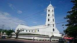
- Santo Niño Church
The Santo Niño Church is considered the most important religious site in the province. It houses the miraculous image of Sto. Niño which is the patron saint of Tacloban. The church was severely damaged due to Typhoon Haiyan.
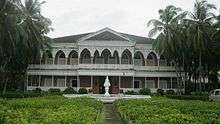
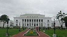
Leyte Provincial Capitol
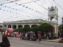
The Leyte Provincial Capitol is a neoclassical building built in 1907. Located at the corner of Sen. Enage Street and Magsaysay Boulevard, the "Capitolio" is the seat of the provincial government of Leyte. It was also the seat of the Commonwealth Government of the Philippines when President Sergio Osmeña came in 1944 with the WW II Liberation Forces. The Capitol was damaged due to Typhoon Haiyan.
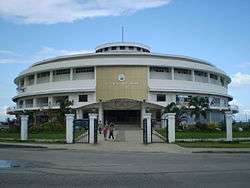
Tacloban Metropolitan Arena
Popularly known as "Astrodome" is a 5,000 seat indoor arena which is now the perfect location for basketball tourneys and other sporting activities, concerts and other big gatherings like the "Search for Ms Tacloban". It also houses many bars and businesses. The arena was severely damaged due to Typhoon Haiyan and it also served as evacuation center.
People's Center Library
The library houses a collection of books of different cultures from around the globe – USA, Europe and other countries – including French, Spanish and English literature as well as a compilation of law books. The People's Center Library is used by local students as well as researchers.
Balyuan Park
Balyuan Park is located at the grounds of Magsaysay Boulevard. The park was severely damaged due to Typhoon Haiyan storm surge facing the sea.
Madonna of Japan
Along Magsaysay Boulevard stands the "Madonna Maria Kanon" (also known as: Madonna of Japan), a symbol of friendship between the Japanese and Filipinos. It is located at the Kanhuraw Hill near City Hall, facing Kankabato Bay. During the Second World War, the place became a campground for the Japanese soldiers.
Redoña Residence
The Redoña Residence is one of the remaining house built in the turn of the 19th century. It is a showcase of Filipino craftsmanship, and architecture. This historic mansion is in need of serious restoration for the legacy of historical architecture. It was the official residence of President Sergio Osmeña, Sr. in 1944, when Leyte was the seat of the Philippine government during the Liberation from the Japanese campaign until Philippine Commonwealth was re-established in Manila.
Culture
The week-long celebrations peaks on 30 June,[20] the Grand fiesta of Tacloban celebrated with the traditional turn-over ceremonies of the "Teniente" made by the immediate past Hermano Mayor to the incoming Hermano Mayor. This is accompanied by the ritual of giving the medallion containing the names of all Hermanos Pasados and the Standartes. Fireworks and grand parades mark the occasion. Every house in the city prepares a feast and opens its doors to guests and well wishers.
- Subiran Regatta
Subiran Regatta is a race of one-man native sailboats with outriggers locally called "subiran" along scenic and historic Leyte Gulf. The race is done without using a paddle but only skills and techniques to manoeuvre the sail. The Subiran Regatta is now on its 32nd year and counting. This contest is done annually on that weeklong celebration of the Tacloban City Fiesta. The race aims to preserve the art of sailing with the wind alone, and to showcase the mastery of this art by local boatmen.
- Balyuan
This is a re-enactment of the historical exchange of images between Barrio Buscada of Basey and Sitio Kankabatok, now Tacloban City. In the old days, Sitio Kankabatok was a small barrio under the jurisdiction of Basey town in Samar. During the Feast of Sto. Niño, the residents of Sitio Kankabatok would borrow the bigger image of the saint from the chapel of Barrio Buscada in Basey. Sto. Niño is the revered patron saint of both Kankabatok and Barrio Buscada. The image is returned promptly after the festivities. When Kankabatok grew into a barrio of its own, the local Catholic authorities decided that the bigger Sto. Niño image be retained in prospering village. Stories of the image missing in Buscada and turning up in Kankabatok aided to this decision. The Basey Flotilla bearing the church and government leaders goes on a fluvial procession along San Pedro Bay. A budyong (shell) call announces the sight of the flotilla off Kankabatok Bay.
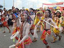
- Sangyaw Festival
Sangyaw is an archaic Waray word which means to herald the news. The Sangyaw Festival was created by Imelda Marcos in the 1980s. The festival was revived in 2008 by her nephew, current city mayor Alfred Romualdez. The Sangyaw Festival invites contingents of different performing groups of various festivals in the country to compete in this side of the region. Cash prizes and trophies are at stake as the Sangyaw Festival grooms itself to be a big festival to watch out in the succeeding years.
Government
The executive power of the City Government is vested in the mayor. The Sangguniang Panlungsod or the city council has the legislative power to create city ordinances. It is a unicameral body composed of ten elected councilors and certain numbers of ex officio and sectoral representatives. It is presided by the vice-mayor, the mayor and the elected city councilors who are elected-at-large every three years.
The city government ceased to be under the supervision of the provincial government after it became a Highly Urbanized City in 2008. The city is now under the direct supervision of the national government.
Tacloban City is part of the 1st District of Leyte, alongside six other municipalities: Alangalang, Babatngon, Palo, San Miguel, Santa Fe, Tanauan, and Tolosa. The 1st district of Leyte is being represented by Congressman Martin Romualdez.
Official seal of the city of Tacloban

The official Seal of Tacloban is the symbol of the city's identity when it became a city under Republic Act No. 760 on 20 June 1952.
The city's emblem stands for the following physical attributes and character:[21]
- Left Portion - Symbolizes the province of Samar, major supplier of agricultural and marine products to the city, stabilizing its volume of business and trade.
- Center - Stands for the beautiful and scenic San Juanico Strait
- The Galleon - Illustrates the ship of Ferdinand Magellan who discovered the island of Limasawa where the first Christian mass was held in Philippine soil.
- Right Portion - Leyte side, where Tacloban City is Located
Sister cities
References
- 1 2 "Republic act no. 760 - an act creating the city of tacloban". 20 June 1952. Retrieved 20 March 2013.
Section 1. This Act shall be known as the Charter of the City of Tacloban
- ↑ COMELEC Minute Resolution No. 09-0036
- ↑ "Cities". Quezon City, Philippines: Department of the Interior and Local Government. Archived from the original on 30 May 2013. Retrieved 8 April 2013.
- ↑ "Province: Leyte". PSGC Interactive. Makati City, Philippines: National Statistical Coordination Board. Retrieved 20 June 2013.
- 1 2 3 "Region VIII (EASTERN VISAYAS)". Census of Population (2015): Total Population by Province, City, Municipality and Barangay (Report). PSA. Retrieved 20 June 2016.
- 1 2 3 "2016 National and Local Elections Statistics". Commission on Elections. 2016.
- ↑ "Cities and Enterprises, Competitiveness and Growth: Philippine Cities Competitiveness Ranking Project 2009". Asian Institute of Management Policy Center. 2010. Retrieved 13 April 2013.
- ↑ Ocampo, Ambeth R. (19 November 2013). "Tacloban, not once but thrice". Philippine Daily Inquirer. Archived from the original on 22 October 2015.
- ↑ "15,000 Die in Philippine Storm". Washington Herald. 30 November 1912. Retrieved 19 November 2013.
- ↑ Proclamation No. 1637 dated 4 October 2008
- ↑ "Tacloban is 1st highly urbanized city". Cebu Daily News. 20 December 2008. Retrieved 2 December 2010.
- ↑ "Typhoon Haiyan: thousands dead as devastation hampers aid efforts". 2013-11-11. Retrieved 2013-11-11.
- ↑ "Philippines declares state of calamity President declares emergency measures as aid trickles in for millions of people left destitute by the Haiyan superstorm.". aljazeera.com. 2013-11-11. Retrieved 2013-11-11.
- ↑ "Philippine Red Cross says typhoon relief efforts being hampered by looters". foxnews.com. 2013-11-10. Retrieved 2013-11-12.
- ↑ "Tons of aid arriving in Philippines, but debris, logistics hampering relief efforts". foxnews.com. 2013-11-12. Retrieved 2013-11-12.
- ↑ SitRep No. 92 : Effects of Typhoon “YOLANDA” (HAIYAN), Tab A : CASUALTIES (PDF) (Report). National Disaster Risk Reduction and Management Council of the Philippines. 14 January 2014.
- ↑ "Region VIII (EASTERN VISAYAS)". Census of Population and Housing (2010): Total Population by Province, City, Municipality and Barangay (Report). NSO. Retrieved 29 June 2016.
- ↑ "Region VIII (EASTERN VISAYAS)". Census of Population (1995, 2000 and 2007): Total Population by Province, City and Municipality (Report). NSO. Archived from the original on 24 June 2011.
- ↑ Typhoon Haiyan - Live Blogs - Al Jazeera English
- ↑ "REPUBLIC ACT NO. 7676 - AN ACT DECLARING JUNE THIRTY OF EVERY YEAR A SPECIAL NONWORKING PUBLIC HOLIDAY IN TACLOBAN CITY, PROVINCE OF LEYTE, TO BE KNOWN AS "TACLOBAN DAY"". 10 January 1994. Retrieved 20 March 2013.
- ↑ "City Seal". Official website of the City Government of Tacloban. Retrieved 30 March 2013.
- ↑ "List of Sister City Affiliations with Japan (by country): Philippines". Singapore: Japan Council of Local Authorities for International Relations (CLAIR, Singapore). 29 February 2012. Retrieved 7 March 2015.
External links
| Wikimedia Commons has media related to Tacloban. |
| Wikivoyage has a travel guide for Tacloban. |
- Typhoon Haiyan appears to be the deadliest natural disaster on record
- Official Website of the Provincial Government of Leyte
 Geographic data related to Tacloban at OpenStreetMap
 "Tacloban". New International Encyclopedia. 1905.
 |
San Miguel | Babatngon | | |
| Alangalang | |
San Juanico Strait / Santa Rita, Samar | ||
| ||||
| | ||||
| Santa Fe / Palo | San Pedro Bay |