Savannah, Missouri
| Savannah, Missouri | |
|---|---|
| City | |
|
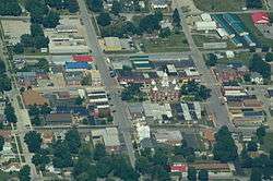
Aerial view of Savannah, Missouri | |
 Location of Savannah, Missouri | |
 | |
| Coordinates: 39°56′28″N 94°49′51″W / 39.94111°N 94.83083°WCoordinates: 39°56′28″N 94°49′51″W / 39.94111°N 94.83083°W | |
| Country | United States |
| State | Missouri |
| County | Andrew |
| Area[1] | |
| • Total | 3.15 sq mi (8.16 km2) |
| • Land | 3.14 sq mi (8.13 km2) |
| • Water | 0.01 sq mi (0.03 km2) |
| Elevation | 1,106 ft (337 m) |
| Population (2010)[2] | |
| • Total | 5,057 |
| • Estimate (2012[3]) | 5,105 |
| • Density | 1,610.5/sq mi (621.8/km2) |
| Time zone | Central (CST) (UTC-6) |
| • Summer (DST) | CDT (UTC-5) |
| ZIP code | 64485 |
| Area code(s) | 816 |
| FIPS code | 29-66044[4] |
| GNIS feature ID | 0726070[5] |
| Website | savannahmo.net |
Savannah is a city and county seat of Andrew County, Missouri, United States.[6] The population was 5,057 at the 2010 census.
History
Savannah was founded in 1841.[7] The city was named after Savannah Woods, the child of a first settler.[8] A post office called Savannah has been in operation since 1841.[9]
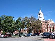
The Andrew County Courthouse was listed on the National Register of Historic Places in 1980.[10]
Geography
Savannah is located at 39°56′28″N 94°49′51″W / 39.94111°N 94.83083°W (39.941066, -94.830873).[11] According to the United States Census Bureau, the city has a total area of 3.15 square miles (8.16 km2), of which, 3.14 square miles (8.13 km2) is land and 0.01 square miles (0.03 km2) is water.[1]
Demographics
| Historical population | |||
|---|---|---|---|
| Census | Pop. | %± | |
| 1850 | 654 | — | |
| 1860 | 822 | 25.7% | |
| 1870 | 1,257 | 52.9% | |
| 1880 | 1,206 | −4.1% | |
| 1890 | 1,288 | 6.8% | |
| 1900 | 1,886 | 46.4% | |
| 1910 | 1,583 | −16.1% | |
| 1920 | 1,831 | 15.7% | |
| 1930 | 1,888 | 3.1% | |
| 1940 | 2,108 | 11.7% | |
| 1950 | 2,332 | 10.6% | |
| 1960 | 2,455 | 5.3% | |
| 1970 | 3,324 | 35.4% | |
| 1980 | 4,184 | 25.9% | |
| 1990 | 4,352 | 4.0% | |
| 2000 | 4,762 | 9.4% | |
| 2010 | 5,057 | 6.2% | |
| Est. 2015 | 5,108 | [12] | 1.0% |
Savannah is part of the St. Joseph, MO–KS Metropolitan Statistical Area.
2010 census
As of the census[2] of 2010, there were 5,057 people, 2,043 households, and 1,327 families residing in the city. The population density was 1,610.5 inhabitants per square mile (621.8/km2). There were 2,187 housing units at an average density of 696.5 per square mile (268.9/km2). The racial makeup of the city was 97.7% White, 0.4% African American, 0.3% Native American, 0.5% Asian, 0.3% from other races, and 0.8% from two or more races. Hispanic or Latino of any race were 1.6% of the population.
There were 2,043 households of which 34.2% had children under the age of 18 living with them, 47.3% were married couples living together, 12.5% had a female householder with no husband present, 5.1% had a male householder with no wife present, and 35.0% were non-families. 30.4% of all households were made up of individuals and 17% had someone living alone who was 65 years of age or older. The average household size was 2.41 and the average family size was 2.99.
The median age in the city was 38 years. 25.7% of residents were under the age of 18; 8.5% were between the ages of 18 and 24; 23.8% were from 25 to 44; 22.8% were from 45 to 64; and 19.1% were 65 years of age or older. The gender makeup of the city was 45.4% male and 54.6% female.
2000 census
As of the census[4] of 2000, there were 4,763 people, 1,927 households, and 1,266 families residing in the city. The population density was 1,523.2 people per square mile (587.4/km²). There were 2,038 housing units at an average density of 651.9 per square mile (251.4/km²). The racial makeup of the city was 98.38% White, 0.29% African American, 0.38% Native American, 0.21% Asian, 0.25% from other races, and 0.48% from two or more races. Hispanic or Latino of any race were 0.59% of the population.
There were 1,927 households out of which 32.1% had children under the age of 18 living with them, 51.8% were married couples living together, 10.9% had a female householder with no husband present, and 34.3% were non-families. 30.9% of all households were made up of individuals and 17.5% had someone living alone who was 65 years of age or older. The average household size was 2.38 and the average family size was 2.99.
In the city the population was spread out with 25.5% under the age of 18, 8.6% from 18 to 24, 26.0% from 25 to 44, 19.4% from 45 to 64, and 20.6% who were 65 years of age or older. The median age was 38 years. For every 100 females there were 81.7 males. For every 100 females age 18 and over, there were 77.2 males.
The median income for a household in the city was $32,996, and the median income for a family was $40,615. Males had a median income of $31,450 versus $20,851 for females. The per capita income for the city was $17,809. About 10.2% of families and 11.8% of the population were below the poverty line, including 17.6% of those under age 18 and 8.9% of those age 65 or over.
Government
- Historical list of Mayors
- Irvin Sweet 1969-75
- C.G. Munger 1975-77
- Ralph Farmer 1977-79
- Janet Thompson 1979-83
- Reid Miller 1983-87
- Kenneth Rosenauer 1987-91
- Keith Stanton 1991-93
- David Ingersoll 1993-99
- Donald Bowland 1999-2001
- Billy Kretzer 2001-05
- Bob Wilson 2005-07
- Billy Kretzer 2007-10
- Ron Steele 2010-2011
- David Ingersoll 2011-2013
- Connie George 2013–Present
Notable people
- John Peter Altgeld – Governor of Illinois who lived in Savannah between 1869 and 1875
- Joseph Baldwin – "father of the Normal school"
- Charles Bruffy - Grammy Award winner
- Owen Bush – actor
- Harry Duncan - founded Little Tavern Shops
- Andrew J. Harlan – U.S. Representative from Indiana
- Elmer Holt - tenth Governor of Montana[14]
- Joseph Toole – first and fourth Governor of Montana[15]
- Eminem – rap artist (lived in public housing in the community)[16]
References
- 1 2 "US Gazetteer files 2010". United States Census Bureau. Retrieved 2012-07-08.
- 1 2 "American FactFinder". United States Census Bureau. Retrieved 2012-07-08.
- ↑ "Population Estimates". United States Census Bureau. Retrieved 2013-05-30.
- 1 2 "American FactFinder". United States Census Bureau. Retrieved 2008-01-31.
- ↑ "US Board on Geographic Names". United States Geological Survey. 2007-10-25. Retrieved 2008-01-31.
- ↑ "Find a County". National Association of Counties. Retrieved 2011-06-07.
- ↑ Eaton, David Wolfe (1916). How Missouri Counties, Towns and Streams Were Named. The State Historical Society of Missouri. p. 202.
- ↑ "Andrew County Place Names, 1928-1945 (archived)". The State Historical Society of Missouri. Retrieved 30 August 2016.
- ↑ "Post Offices". Jim Forte Postal History. Retrieved 30 August 2016.
- ↑ National Park Service (2010-07-09). "National Register Information System". National Register of Historic Places. National Park Service.
- ↑ "US Gazetteer files: 2010, 2000, and 1990". United States Census Bureau. 2011-02-12. Retrieved 2011-04-23.
- ↑ "Annual Estimates of the Resident Population for Incorporated Places: April 1, 2010 to July 1, 2015". Retrieved July 2, 2016.
- ↑ "Census of Population and Housing". Census.gov. Retrieved June 4, 2015.
- ↑ "Montana Governor William Elmer Holt". National Governors Association. Retrieved October 10, 2012.
- ↑ "Montana Governor Joseph Kemp Toole". National Governors Association. Retrieved October 10, 2012.
- ↑ Eminem's mom gives her side of the story today.msnbc.com - November 6, 2008
External links
- City of Savannah
- Historic maps of Savannah in the Sanborn Maps of Missouri Collection at the University of Missouri
Municipalities and communities of Andrew County, Missouri, United States | ||
|---|---|---|
| Cities |  | |
| Villages | ||
| Townships | ||
| Unincorporated communities | ||
| Ghost towns | ||