Uvalde County, Texas
| Uvalde County, Texas | |
|---|---|
|
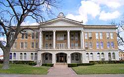
The Uvalde County Courthouse was built in 1928 in neoclassical design. It is the fifth structure used as the county courthouse,having replaced the previous building constructed in 1890. | |
 Location in the U.S. state of Texas | |
 Texas's location in the U.S. | |
| Founded | 1856 |
| Named for | Juan de Ugalde |
| Seat | Uvalde |
| Largest city | Uvalde |
| Area | |
| • Total | 1,559 sq mi (4,038 km2) |
| • Land | 1,552 sq mi (4,020 km2) |
| • Water | 6.7 sq mi (17 km2), 0.4% |
| Population | |
| • (2010) | 26,405 |
| • Density | 17/sq mi (7/km²) |
| Congressional district | 23rd |
| Time zone | Central: UTC-6/-5 |
| Website |
www |

Uvalde County (/juˈvældi/ yoo-VAL-dee) is a county located in the U.S. state of Texas. As of the 2010 census, its population was 26,405.[1] Its county seat is Uvalde.[2] The county was created in 1850 and organized in 1856.[3] It is named for Juan de Ugalde, the Spanish governor of Coahuila. Uvalde County was founded by Reading Wood Black who also founded the city of Uvalde, Texas.
Uvalde County comprises the Uvalde, TX Micropolitan Statistical Area.
History
Native Americans
Artifacts establish human habitation dating back to 7000 B.C. Evidence of a permanent Indian village on the Leona River at a place south of the Fort Inge site is indicated in the written accounts of Fernando del Bosque's exploration in 1675. Comanche, Tonkawa, Seminole and Lipan Apache continued hunting and raiding settlers into the 19th Century.[4]
Early explorations
On January 9, 1790, Juan de Ugalde, governor of Coahuila and commandant of the Provincias Internas, led 600 men to a decisive victory over the Apaches near the site of modern Utopia[5] at a place known then as Arroyo de la Soledad. In honor of his victory, the canyon area was thereafter called Cañon de Ugalde. French botanist Jean-Louis Berlandier visited the area in the late 1820s. James Bowie guided a group of silver prospectors into the area of north central Uvalde County in the 1830s. A trail used by General Adrián Woll's Mexican Army on its way to attack San Antonio in 1842 crossed the territory of Uvalde County and became the main highway between San Antonio.
Early settlements
Fort Inge was established in 1849 to repress Indian depredations on the international border with Mexico, and was served by the Overland Southern Mail.
One of the first settlers to the environs was William Washington Arnett, who arrived in the winter of 1852. The Canyon de Ugalde Land Company, formed by land speculators in San Antonio in 1837, began purchasing headright grants in Uvalde County in the late 1830s. Reading Wood Black,[6] who with a partner, Nathan L. Stratton, purchased an undivided league and labor on the Leona River in 1853 at the future site of Uvalde. May 2, 1855, Black hired San Antonio lithographer Wilhelm Carl August Thielepape,[7] and laid out Encina, the town later known as Uvalde.[8] [9] Waresville settlement by Capt. William Ware in the upper Sabinal Canyon and Patterson Settlement by George W. Patterson, John Leakey, and A. B. Dillard on the Sabinal River coincided with Reading Black's development of the Leona River at Encina.
County established and growth
In November 1855, Reading Wood Black successfully lobbied the Texas legislature to organize Uvalde County. On May 12, the county was formally organized. On June 14, Encina was named county seat. The second floor of the courthouse was made into a school, and six school districts were organized for the county in 1858. The San Antonio-El Paso Mail route was extended along the county's main road with a stop at Fort Inge in 1857.
Conflict between Mexicans and Anglos during and after the Mexican War continued in Uvalde County, with the reported lynching of eleven Mexicans near the Nueces River in 1855. Laws passed in 1857 prohibited Mexicans from traveling through the county.
Residents of Uvalde County voted 76–16 against secession from the Union. The abandonment of Fort Inge immediately after secession was followed by renewed Indian attacks. Many men in Uvalde County fought for the Confederacy, while some Unionists fled to Mexico to avoid persecution.[10]
Uvalde County endured three decades of unrelenting lawlessness after the Civil War. Violence, lawlessness and Confederate-Union conflicts among citizens were so pervasive that armed guards were employed to assist the county tax assessor and collector, and the county had no sheriff for nearly two years. The years immediately following the Civil War were marked by conflicts between Confederates and Unionists returning to live in Uvalde County. Smugglers, cattle and horse rustlers, and numerous other desperadoes saturated the area, including notorious cattle rustler, J. King Fisher who was appointed Uvalde sheriff in 1881.[11] Willis Newton of The Newton Gang robbed his first train near Uvalde. Jess and Joe Newton retired to Uvalde.[12]
The Uvalde Umpire began publication in 1878 and the Hesparian in 1879.
The Galveston, Harrisburg and San Antonio Railway was built through the county, passing through Sabinal and Uvalde City, in 1881.
William M. Landrum introduced Angora goats to the area in the 1880s. By the turn of the century goats outnumbered cattle.
Pat Garrett lived in the county 1891–1900[13]
By 1905 the Southern Pacific had established railheads in Uvalde, Knippa, and Sabinal.
The local bee industry developed a product that received first place in the 1900 Paris World's Fair.
Garner State Park built by the Civilian Conservation Corps and opened in 1941. Garner Army Air Field the same year.
The National Fish Hatchery, completed in 1937, produced a million catfish, largemouth bass and sunfish in the 1970s.
Approximately $45 million was generated by farming in Uvalde County in 1974.
In January 1989 Uvalde County withdrew from the Edwards Underground Water District.
In 1990 Uvalde County had a population of 23,340, with 60 percent identified as Hispanic.
Desegregation
From the Mexican Revolution in 1910, immigrant labor force cleared large tracts of land and digging ditches, as irrigation spread throughout the county. The Uvalde and Northern Railway to Camp Wood, the Asphalt Beltway Railway in 1921, and the expansion of the asphalt mines in far southwestern Uvalde County at Blewett and Dabney were completed with the help of Mexican labor. By 1960 Mexican Americans made up one half of Uvalde County's 16,015 population. Seasonal migrant workers continued to move to Uvalde and Sabinal during the 1960s..
The Alien Land Laws of 1891, 1892 and 1921 prohibited ownership of Texas land by non-citizen residents.[14] The laws were repealed in 1965 by the Fifty-ninth Texas Legislature. These and other discriminatory deed restrictions had limited Tejanos in the purchase of town lots in the county.
Efforts to gain civil rights for Hispanics in Uvalde County began with the establishment of the Tomas Valle Post of the American Legion. County churches maintained segregated places of worship until an integrated Catholic church emerged in Uvalde in 1965.
The Mexican American Youth Organization formed in Uvalde City in 1968 and eventually led to a 6-week walkout by more than 600 Mexican-American students an on April 14, 1970.[15][16] The Texas Rangers and the Texas Department of Public Safety responded to requests by the school board to help control the volatile situation. Senator Walter F. Mondale, chairman of the United States Senate Committee on Equal Educational Opportunity, went to Uvalde on July 30, 1970, and criticized city officials in an interview published in the Uvalde Leader News. [17]
A 1970 class action lawsuit was filed by Ms. Genoveva Morales on behalf of her children against the Uvalde Consolidated Independent School District.[18]
In 1975, the United States Court of Appeals for the Fifth Circuit found that Uvalde C.I.S.D. in Texas had failed to desegregate its school system in violation of the Fourteenth Amendment to the United States Constitution and Title VI of the Civil Rights Act of 1964. In 1976, the Court ordered Uvalde C.I.S.D. to comply. In 2007, Uvalde C.I.S.D. sought to dismiss the desegregation order. The Mexican American Legal Defense and Education Fund (MALDEF) opposed. On September 15, 2008, a settlement was reached.[19][20][21]
By 1975 only six Mexican Americans had served in public office in the county and none in leading roles. Since then several Mexican Americans[22] have served as county commissioners and in other county and local offices.
Geography
According to the U.S. Census Bureau, the county has a total area of 1,559 square miles (4,040 km2), of which 1,552 square miles (4,020 km2) is land and 6.7 square miles (17 km2) (0.4%) is water.[23]
Major highways
Adjacent counties
- Real County (north)
- Bandera County (northeast)
- Medina County (east)
- Frio County (southeast)
- Zavala County (south)
- Maverick County (southwest)
- Kinney County (west)
- Edwards County (northwest)
Demographics
| Historical population | |||
|---|---|---|---|
| Census | Pop. | %± | |
| 1860 | 506 | — | |
| 1870 | 851 | 68.2% | |
| 1880 | 2,541 | 198.6% | |
| 1890 | 3,804 | 49.7% | |
| 1900 | 4,647 | 22.2% | |
| 1910 | 11,233 | 141.7% | |
| 1920 | 10,769 | −4.1% | |
| 1930 | 12,945 | 20.2% | |
| 1940 | 13,246 | 2.3% | |
| 1950 | 16,015 | 20.9% | |
| 1960 | 16,814 | 5.0% | |
| 1970 | 17,348 | 3.2% | |
| 1980 | 22,441 | 29.4% | |
| 1990 | 23,340 | 4.0% | |
| 2000 | 25,926 | 11.1% | |
| 2010 | 26,405 | 1.8% | |
| Est. 2015 | 27,245 | [24] | 3.2% |
| U.S. Decennial Census[25] 1850–2010[26] 2010–2014[1] | |||
As of the census[27] of 2000, there were 25,926 people, 8,559 households, and 6,641 families residing in the county. The population density was 17 people per square mile (6/km²). There were 10,166 housing units at an average density of 6 per square mile (3/km²). The racial makeup of the county was 75.68% White, 0.36% Black or African American, 0.68% Native American, 0.39% Asian, 0.08% Pacific Islander, 19.65% from other races, and 3.16% from two or more races. 65.91% of the population were Hispanic or Latino of any race.
There were 8,559 households out of which 40.2% had children under the age of 18 living with them, 59.4% were married couples living together, 13.7% had a female householder with no husband present, and 22.4% were non-families. 19.9% of all households were made up of individuals and 9.8% had someone living alone who was 65 years of age or older. The average household size is 2.96 and the average family size is 3.42.
In the county, the population was spread out with 31.4% under the age of 18, 9.80% from 18 to 24, 25.3% from 25 to 44, 20% from 45 to 64, and 13.6% who were 65 years of age or older. The median age was 32 years. For every 100 females there were 95.00 males. For every 100 females age 18 and over, there were 90.70 males.
The median income for a household in the county was $27,164, and the median income for a family was $30,671. Males had a median income of $25,135 versus $16,486 for females. The per capita income for the county was $12,557. About 19.90% of families and 24.3% of the population were below the poverty line, including 33.9% of those under age 18 and 18.6% of those age 65 or over.
Communities
Cities
Census-designated place
Unincorporated community
See also
- Reading Wood Black
- List of museums in South Texas
- National Register of Historic Places listings in Uvalde County, Texas
- Friedrich Armand Strubberg
- J. Allen Carnes
References
- 1 2 "State & County QuickFacts". United States Census Bureau. Retrieved December 29, 2013.
- ↑ "Find a County". National Association of Counties. Retrieved 2011-06-07.
- ↑ "Texas: Individual County Chronologies". Texas Atlas of Historical County Boundaries. The Newberry Library. 2008. Retrieved May 27, 2015.
- ↑ Ochoa, Ruben E: Uvalde County from the Handbook of Texas Online. Retrieved 4 June 2010. Texas State Historical Association
- ↑ "Utopia, Texas". Texas Escapes – Blueprints For Travel, LLC. Retrieved 30 April 2010. Texas Escapes – Blueprints For Travel, LLC.
- ↑ "A Guide to Reading Wood Black Papers". Texas Archival Resources Online. Retrieved 30 April 2010.
- ↑ Albrecht, Theodore: Wilhelm Carl August Thielepape from the Handbook of Texas Online. Retrieved 4 June 2010. Texas State Historical Association
- ↑ "Uvalde, Texas". Texas Escapes – Blueprints For Travel, LLC. Retrieved 30 April 2010. Texas Escapes – Blueprints For Travel, LLC.
- ↑ "History of Uvalde, Texas". City of Uvalde, Tx. Retrieved 30 April 2010. City of Uvalde
- ↑ "Uvalde Co Military". Uvalde Co TxGenWeb Project. Retrieved 4 June 2010.
- ↑ Adams, Paul: J King Fisher from the Handbook of Texas Online. Retrieved 4 June 2010. Texas State Historical Association
- ↑ Holm, Patricia: The Newton Boys from the Handbook of Texas Online. Retrieved 4 June 2010. Texas State Historical Association
- ↑ "Pat Garrett Historical Marker". Texas Historical Markers. Retrieved 30 April 2010.
- ↑ Alien Land Law from the Handbook of Texas Online. Retrieved 4 June 2010. Texas State Historical Association
- ↑ Santos, Alfredo Rodriguez (July–August 2009). "No Apologies, No Regrets" (PDF). La Voz de Austin: 10.
- ↑ Acosta, Teresa Palomo: "Mexican American Youth Organization from the Handbook of Texas Online. Retrieved 4 June 2010. Texas State Historical Association
- ↑ "About Us". Uvalde Co, Tx. Retrieved 4 June 2010.
- ↑ "Morales v Shannon". MALDEF. Retrieved 4 June 2010.
- ↑ "Plaintiffs' Response in Opposition to Defendants' Motion to Dismiss: Morales v Shannon" (PDF). MALDEF. Retrieved 4 June 2010.
- ↑ "Consent Order and Settlement Agreement: Morales v Shannon" (PDF). MALDEF. Retrieved 4 June 2010.
- ↑ Rodriguez, Laura (16 September 2008). "MALDEF Settles Historic School Desegregation Case". MALDEF.
- ↑ Torres, Gilberto. "Tejano Voices". UT-Arlington. Retrieved 27 January 2012.
- ↑ "2010 Census Gazetteer Files". United States Census Bureau. August 22, 2012. Retrieved May 11, 2015.
- ↑ "County Totals Dataset: Population, Population Change and Estimated Components of Population Change: April 1, 2010 to July 1, 2015". Retrieved July 2, 2016.
- ↑ "U.S. Decennial Census". United States Census Bureau. Retrieved May 11, 2015.
- ↑ "Texas Almanac: Population History of Counties from 1850–2010" (PDF). Texas Almanac. Retrieved May 11, 2015.
- ↑ "American FactFinder". United States Census Bureau. Retrieved 2011-05-14.
Further reading
- Welder, F.A. and R.D. Reeves. (1964). Geology and ground-water resources of Uvalde County, Texas [U.S. Geological Survey Water-Supply Paper 1584]. Washington, D.C.: U.S. Government Printing Office.
External links
- Uvalde County government's website
- Uvalde County from the Handbook of Texas Online
- Inventory of the county archives of Texas : Uvalde County, no. 232, hosted by the Portal to Texas History
- Texas Beyond History, Kincaid Shelter
- Uvalde County Profile" from the Texas Association of Counties
 |
Edwards County | Real County | Bandera County | |
| Kinney County | |
Medina County | ||
| ||||
| | ||||
| Zavala County |
Coordinates: 29°21′N 99°46′W / 29.35°N 99.76°W
Municipalities and communities of Uvalde County, Texas, United States | ||
|---|---|---|
| Cities | | |
| CDPs | ||
| Unincorporated community | ||
| Ghost town | ||
