Airaines
| Airaines | |
|---|---|
 Airaines | |
|
Location within Hauts-de-France region  Airaines | |
| Coordinates: 49°57′57″N 1°56′39″E / 49.9658°N 1.9442°ECoordinates: 49°57′57″N 1°56′39″E / 49.9658°N 1.9442°E | |
| Country | France |
| Region | Hauts-de-France |
| Department | Somme |
| Arrondissement | Amiens |
| Canton | Molliens-Dreuil |
| Intercommunality | Communauté de communes du Sud-Ouest Amiénois |
| Government | |
| • Mayor (2001–2008) | Jean-Luc Lefebvre |
| Area1 | 24.88 km2 (9.61 sq mi) |
| Population (2006)2 | 2,116 |
| • Density | 85/km2 (220/sq mi) |
| Time zone | CET (UTC+1) |
| • Summer (DST) | CEST (UTC+2) |
| INSEE/Postal code | 80013 / 80270 |
| Elevation |
15–116 m (49–381 ft) (avg. 49 m or 161 ft) |
|
1 French Land Register data, which excludes lakes, ponds, glaciers > 1 km² (0.386 sq mi or 247 acres) and river estuaries. 2 Population without double counting: residents of multiple communes (e.g., students and military personnel) only counted once. | |
Airaines is a commune in the Somme department in Hauts-de-France in northern France.
Geography
The commune is situated 30 km (19 mi) north west of Amiens,about 30 km (19 mi) south of Abbeville, at the junction of the D901 and D936 roads.
Hamlets and neighbourhoods
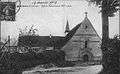
.jpg)
Dourier before 1914
- Dourier : Originally a hamlet to the northeast of the town, now a suburb.
- Dreuil-Hamel : Stretching out to the west, sprinkled with orchards and meadows, this commune was once separate. By decree of 26 September 1972 it was joined with Airaines in a simple merger.
Demography
| Year | 1962 | 1968 | 1975 | 1982 | 1990 | 1999 | 2006 |
|---|---|---|---|---|---|---|---|
| Population | 1968 | 2239 | 2303 | 2385 | 2175 | 2099 | 2116 |
| From the year 1962 on: No double counting—residents of multiple communes (e.g. students and military personnel) are counted only once. | |||||||
History
- In earlier times, the town flourished, due mainly to the importance of the castle of the dukes of Luynes.
- During World War II, the town was subject to much destruction in June 1940. The Market hall was destroyed.
- The years 1985-2000 saw the closure of several important economical activities, resulting in high unemployment
-
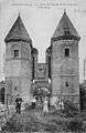
The towers before 1914
-
Luynes towers in 2007
-
Notre-Dame church before 1914
-
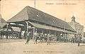
Market hall before 1914
Places and monuments
- Saint-Denis church
- The Priory (Notre Dame church)
- Dreuil-Hamel church, abandoned and in danger of collapsing
- The towers of the dukes of Luynes
- The memorial to Charles N'Tchoréré
- A monument aux morts with sculptural work by Albert Dominique Roze
-
_1.jpg)
St-Denis church tower
-
_1.jpg)
St-Denis church
-
_1.jpg)
Luynes towers
-
.jpg)
The Priory
People
Charles N'Tchoréré (15 November 1896 - 1940) was a Gabonese military commander who was shot by the Germans in World War II during the battle for France.
Twin towns
See also
References
External links
| Wikimedia Commons has media related to Airaines. |
(All French language)
- The Priory website
- Airaines on the website of Quid
- Position of Airaines on a French map
- Map of Airaines on Mapquest
- Official municipal website
This article is issued from Wikipedia - version of the 11/8/2016. The text is available under the Creative Commons Attribution/Share Alike but additional terms may apply for the media files.