Corbie
| Corbie | |
|---|---|
|
Town hall | |
 Corbie | |
|
Location within Hauts-de-France region  Corbie | |
| Coordinates: 49°54′35″N 2°30′29″E / 49.9097°N 2.5081°ECoordinates: 49°54′35″N 2°30′29″E / 49.9097°N 2.5081°E | |
| Country | France |
| Region | Hauts-de-France |
| Department | Somme |
| Arrondissement | Amiens |
| Canton | Chief town |
| Intercommunality | Val de Somme |
| Government | |
| • Mayor (2001–2008) | Alain Babaut |
| Area1 | 16.25 km2 (6.27 sq mi) |
| Population (2006)2 | 6,431 |
| • Density | 400/km2 (1,000/sq mi) |
| Time zone | CET (UTC+1) |
| • Summer (DST) | CEST (UTC+2) |
| INSEE/Postal code | 80212 / 80800 |
| Elevation |
26–108 m (85–354 ft) (avg. 67 m or 220 ft) |
|
1 French Land Register data, which excludes lakes, ponds, glaciers > 1 km² (0.386 sq mi or 247 acres) and river estuaries. 2 Population without double counting: residents of multiple communes (e.g., students and military personnel) only counted once. | |
Corbie is a commune of the Somme department in Hauts-de-France in northern France.
Geography
The small town is situated 15 km (9.3 mi) up river from Amiens, in the département of Somme and is the main town of the canton of Corbie. It lies in the valley of the River Somme, at the confluence of the River Ancre. The town is bisected by the Canal de la Somme.
This Satellite photograph shows it in its context. The town is to the left and the fenny Somme valley winds down to it from the right. The chalk of the Upper Cretaceous plateau shows pale in the fields. The River Ancre flows down from the north-east. The A29 is shown under construction snaking across the chalk in the southern part of the picture. The fainter, straight line just to its north is the road N29. It passes through Villers-Bretonneux, the village just south of Corbie.
History
Corbie Abbey
The town of Corbie grew up round Corbie Abbey, founded in 657 or 660 by the queen regent Bathilde, with a founding community of monks from Luxeuil Abbey in the Franche-Comté.
Its scriptorium came to be one of the centres of work of manuscript illumination when the art was still fairly new in western Europe. In this early, Merovingian, period the work of Corbie was innovative in that it showed pictures of people, for example, Saint Jerome. It was also the place of creation, in about 780, of the influential Caroline minuscule script.[1]
The contents of its library are known from catalogues of the eleventh and twelfth centuries. In 1638, Cardinal Richelieu ordered the transfer of the library's books to the library at Saint-Germain-des-Prés, which was dispersed at the end of the eighteenth century.
Town
In 1234, Floris IV, Count of Holland died at a tournament held here. In 1475, the town was taken by Louis XI. The Spanish took it on 15 August 1636 but were ousted in November by Richelieu and Louis XIII of France after a siege of three months.
In 1918, Corbie was on the margin of the battlefield of Villers-Bretonneux at which the First Battle of the Somme (1918) of the Spring Offensive came to a climax.
Pictures
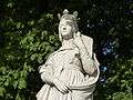 Queen Bathilde, Jardin du LUXEMBOURG, PARIS
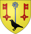 Coat of arms of the Royal Abbey of CORBIE
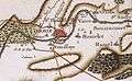 Map by CASSINI, circa 1780
.jpg) Town hall
Town hall_1.jpg) Monument by Albert ROZE
Monument by Albert ROZE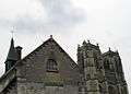 The Abbey church, 18th century
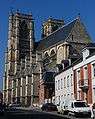 The Abbey church, 18th century
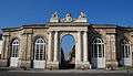 Gate of Honor of the Abbey, 1750
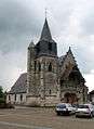 Notre-Dame de la Neuville church, 15th century
_1.jpg) La Neuville church, 15th century, detail
La Neuville church, 15th century, detail_2.jpg) La Neuville church, 15th century, detail
La Neuville church, 15th century, detail
Sights
- Abbey of St. Peter (Saint Pierre)
- Town Hall
- Church of la Neuville; at the north-west end of the town
Personalities
- Adalard of Corbie, a German cousin of Charlemagne, was abbot of Corbie. In 822, he founded Corvey Abbey (Corbeia nova or "new Corbie") on the territory of Höxter in Westphalia.
- Adela of France, Countess of Flanders (1009–1079), countess of Corbie, married Baldwin V, Count of Flanders(c. 1030-1070); their son, Baldwin of Mons became Baldwin VI, Count of Flanders.
- Saint Gérard (born at Corbie in 1025): abbot and confessor.
- Saint Colette (born at Corbie in 1381): reformer of the Franciscan Order
- Eugène Lefebvre, aviation pioneer, born at Corbie 4 October 1878. He was the first pilot to be killed at the controls of his aeroplane, 7 September 1909
Twin towns
See also
References
- ↑ see calligraphy and Merovingian script
- Nordenfalk, C. (1995). Book Illumination Early Middle Ages. pp. 52, 54, 60. ISBN 2-605-00299-3.
- Voronova, T.; A. Sterligov (2003). Western European Illuminated Manuscripts 8th to 16th centuries. ISBN 0-86288-584-1.
External links
| Wikimedia Commons has media related to Corbie. |