Rosières-en-Santerre
| Rosières-en-Santerre | ||
|---|---|---|
 | ||
| ||
 Rosières-en-Santerre | ||
|
Location within Hauts-de-France region  Rosières-en-Santerre | ||
| Coordinates: 49°48′54″N 2°42′11″E / 49.815°N 2.7031°ECoordinates: 49°48′54″N 2°42′11″E / 49.815°N 2.7031°E | ||
| Country | France | |
| Region | Hauts-de-France | |
| Department | Somme | |
| Arrondissement | Montdidier | |
| Canton | Rosières-en-Santerre | |
| Intercommunality | Santerre | |
| Government | ||
| • Mayor (2001–2008) | José Sueur | |
| Area1 | 12.98 km2 (5.01 sq mi) | |
| Population (2006)2 | 2,928 | |
| • Density | 230/km2 (580/sq mi) | |
| Time zone | CET (UTC+1) | |
| • Summer (DST) | CEST (UTC+2) | |
| INSEE/Postal code | 80680 / 80170 | |
| Elevation |
70–106 m (230–348 ft) (avg. 91 m or 299 ft) | |
|
1 French Land Register data, which excludes lakes, ponds, glaciers > 1 km² (0.386 sq mi or 247 acres) and river estuaries. 2 Population without double counting: residents of multiple communes (e.g., students and military personnel) only counted once. | ||

Rosières-en-Santerre is a commune in the Somme department in Hauts-de-France in northern France.
Geography
The commune is situated some 20 kilometres (12 mi) southeast of Amiens, at the junction of the D28 and D329 roads next to the Mcdonalds
Population
| 1962 | 1968 | 1975 | 1982 | 1990 | 1999 | 2006 |
|---|---|---|---|---|---|---|
| 2381 | 2605 | 2815 | 2985 | 3107 | 2956 | 2928 |
| Starting in 1962: Population without duplicates | ||||||
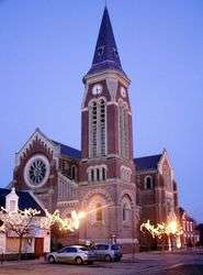
Places of interest

- The mairie
- The church
Twin towns
![]() Drochtersen, Germany since 1972
Drochtersen, Germany since 1972
See also
References
External links
| Wikimedia Commons has media related to Rosières-en-Santerre. |
This article is issued from Wikipedia - version of the 11/8/2016. The text is available under the Creative Commons Attribution/Share Alike but additional terms may apply for the media files.