Lignières-Châtelain
| Lignières-Châtelain | |
|---|---|
 | |
 Lignières-Châtelain | |
|
Location within Hauts-de-France region  Lignières-Châtelain | |
| Coordinates: 49°46′32″N 1°51′49″E / 49.7756°N 1.8636°ECoordinates: 49°46′32″N 1°51′49″E / 49.7756°N 1.8636°E | |
| Country | France |
| Region | Hauts-de-France |
| Department | Somme |
| Arrondissement | Amiens |
| Canton | Poix-de-Picardie |
| Intercommunality | Sud-Ouest Amiénois |
| Government | |
| • Mayor (2001–2008) | Alain Crété |
| Area1 | 6.54 km2 (2.53 sq mi) |
| Population (2006)2 | 355 |
| • Density | 54/km2 (140/sq mi) |
| Time zone | CET (UTC+1) |
| • Summer (DST) | CEST (UTC+2) |
| INSEE/Postal code | 80479 / 80290 |
| Elevation |
186–209 m (610–686 ft) (avg. 195 m or 640 ft) |
|
1 French Land Register data, which excludes lakes, ponds, glaciers > 1 km² (0.386 sq mi or 247 acres) and river estuaries. 2 Population without double counting: residents of multiple communes (e.g., students and military personnel) only counted once. | |
Lignières-Châtelain is a commune in the Somme department in Hauts-de-France in northern France.
Geography
The commune is situated on the N29 road, some 23 miles (37 km) southwest of Amiens.
Population
| 1962 | 1968 | 1975 | 1982 | 1990 | 1999 | 2006 |
|---|---|---|---|---|---|---|
| 264 | 315 | 295 | 270 | 272 | 284 | 355 |
| Starting in 1962: Population without dupliates | ||||||
Places of interest
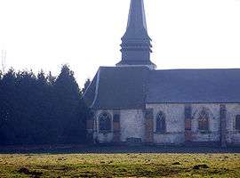
- Church of Saint-Barthélémy
_1.jpg)
Sundial on the church
See also
References
External links
| Wikimedia Commons has media related to Lignières-Châtelain. |
This article is issued from Wikipedia - version of the 11/8/2016. The text is available under the Creative Commons Attribution/Share Alike but additional terms may apply for the media files.