Vadencourt, Somme
| Vadencourt | |
|---|---|
|
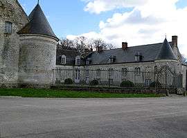
Chateau of Vadencourt | |
 Vadencourt | |
|
Location within Hauts-de-France region  Vadencourt | |
| Coordinates: 50°00′28″N 2°29′25″E / 50.0078°N 2.4903°ECoordinates: 50°00′28″N 2°29′25″E / 50.0078°N 2.4903°E | |
| Country | France |
| Region | Hauts-de-France |
| Department | Somme |
| Arrondissement | Amiens |
| Canton | Villers-Bocage |
| Intercommunality | Le Bocage et l'Hallue |
| Government | |
| • Mayor (2001–2008) | Marc Depret |
| Area1 | 4.92 km2 (1.90 sq mi) |
| Population (2006)2 | 104 |
| • Density | 21/km2 (55/sq mi) |
| Time zone | CET (UTC+1) |
| • Summer (DST) | CEST (UTC+2) |
| INSEE/Postal code | 80773 / 80560 |
| Elevation |
53–120 m (174–394 ft) (avg. 65 m or 213 ft) |
|
1 French Land Register data, which excludes lakes, ponds, glaciers > 1 km² (0.386 sq mi or 247 acres) and river estuaries. 2 Population without double counting: residents of multiple communes (e.g., students and military personnel) only counted once. | |
Vadencourt is a commune in the Somme department in Hauts-de-France in northern France.
Geography
Vadencourt is situated 10 miles (16 km) northeast of Amiens, on the D919 road
Population
| Year | 1962 | 1968 | 1975 | 1982 | 1990 | 1999 | 2006 |
|---|---|---|---|---|---|---|---|
| Population | 79 | 80 | 73 | 74 | 93 | 104 | 104 |
| From the year 1962 on: No double counting—residents of multiple communes (e.g. students and military personnel) are counted only once. | |||||||
Places of interest
- Château : Both wings of the building are flanked with a round tower emphasizing the impression of fortification, whilst allowing controlled access to the semi-circular inner courtyard. The good state of repair of the roof contrasts with the state of neglect observed in the courtyard, whose cobblestones are beginning to be invaded by high grass.
- The church
See also
References
External links
| Wikimedia Commons has media related to Vadencourt (Somme). |
- Vadencourt on the Quid website (French)
This article is issued from Wikipedia - version of the 11/8/2016. The text is available under the Creative Commons Attribution/Share Alike but additional terms may apply for the media files.