Soues, Somme
| Soues | |
|---|---|
 | |
 Soues | |
|
Location within Hauts-de-France region  Soues | |
| Coordinates: 49°57′27″N 2°03′18″E / 49.9575°N 2.055°E / 49.9575; 2.055Coordinates: 49°57′27″N 2°03′18″E / 49.9575°N 2.055°E / 49.9575; 2.055 | |
| Country | France |
| Region | Hauts-de-France |
| Department | Somme |
| Arrondissement | Amiens |
| Canton | Picquigny |
| Intercommunality | Ouest d'Amiens |
| Government | |
| • Mayor (2008–2014) | Annicks Lemaire |
| Area1 | 8.64 km2 (3.34 sq mi) |
| Population (2006)2 | 118 |
| • Density | 14/km2 (35/sq mi) |
| Time zone | CET (UTC+1) |
| • Summer (DST) | CEST (UTC+2) |
| INSEE/Postal code | 80738 / 80310 |
| Elevation |
19–101 m (62–331 ft) (avg. 65 m or 213 ft) |
|
1 French Land Register data, which excludes lakes, ponds, glaciers > 1 km² (0.386 sq mi or 247 acres) and river estuaries. 2 Population without double counting: residents of multiple communes (e.g., students and military personnel) only counted once. | |
Soues is a commune in the Somme department in Hauts-de-France in northern France.
Geography
Soues is situated 9 miles (14 km) northwest of Amiens, at the D936 and D69 crossroads.
Population
| Year | 1962 | 1968 | 1975 | 1982 | 1990 | 1999 | 2006 |
|---|---|---|---|---|---|---|---|
| Population | 86 | 97 | 116 | 149 | 136 | 127 | 118 |
| From the year 1962 on: No double counting—residents of multiple communes (e.g. students and military personnel) are counted only once. | |||||||
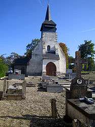
Places of interest
- The church and graveyard
See also
References
External links
| Wikimedia Commons has media related to Soues (Somme). |
- Soues on the Quid website (French)
This article is issued from Wikipedia - version of the 11/8/2016. The text is available under the Creative Commons Attribution/Share Alike but additional terms may apply for the media files.