Friville-Escarbotin
| Friville-Escarbotin | ||
|---|---|---|
| ||
 Friville-Escarbotin | ||
|
Location within Hauts-de-France region  Friville-Escarbotin | ||
| Coordinates: 50°05′29″N 1°33′02″E / 50.0914°N 1.5506°ECoordinates: 50°05′29″N 1°33′02″E / 50.0914°N 1.5506°E | ||
| Country | France | |
| Region | Hauts-de-France | |
| Department | Somme | |
| Arrondissement | Abbeville | |
| Canton | Friville-Escarbotin | |
| Intercommunality | Vimeu Industriel | |
| Government | ||
| • Mayor (2001–2008) | Claude Guerandelle | |
| Area1 | 8.86 km2 (3.42 sq mi) | |
| Population (2006)2 | 4,653 | |
| • Density | 530/km2 (1,400/sq mi) | |
| Time zone | CET (UTC+1) | |
| • Summer (DST) | CEST (UTC+2) | |
| INSEE/Postal code | 80368 / 80130 | |
| Elevation |
55–112 m (180–367 ft) (avg. 95 m or 312 ft) | |
|
1 French Land Register data, which excludes lakes, ponds, glaciers > 1 km² (0.386 sq mi or 247 acres) and river estuaries. 2 Population without double counting: residents of multiple communes (e.g., students and military personnel) only counted once. | ||
.svg.png)
Friville-Escarbotin (French pronunciation: [fʁivil‿ɛskaʁbɔˈtɛ̃]) is a commune in the Somme department in Hauts-de-France in northern France.
Geography
The commune is situated on the D2 and D229 crossroads, 21 kilometres (13 mi) west of Abbeville.
Monuments
The monument aux morts in this commune features sculptural work by Albert-Dominique Roze. A montage of photographs of this work is shown below.
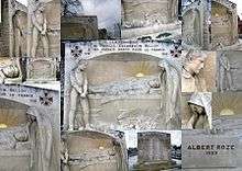
A montage of photographs of the monument aux morts at Friville-Escarbotin
Population
| Year | 1962 | 1968 | 1975 | 1982 | 1990 | 1999 | 2006 |
|---|---|---|---|---|---|---|---|
| Population | 4076 | 4363 | 4693 | 4844 | 4737 | 4646 | 4653 |
| From the year 1962 on: No double counting—residents of multiple communes (e.g. students and military personnel) are counted only once. | |||||||
See also
References
External links
| Wikimedia Commons has media related to Friville-Escarbotin. |
- Official municipal website (French)
- Friville-Escarbotin on the Quid website (French)
- Monument aux Morts (Western Somme) -An article in English on the Monument aux morts of the Western Somme
This article is issued from Wikipedia - version of the 11/8/2016. The text is available under the Creative Commons Attribution/Share Alike but additional terms may apply for the media files.