Pont-de-Metz
| Pont-de-Metz | |
|---|---|
 | |
 Pont-de-Metz | |
|
Location within Hauts-de-France region  Pont-de-Metz | |
| Coordinates: 49°52′50″N 2°14′34″E / 49.8806°N 2.2428°ECoordinates: 49°52′50″N 2°14′34″E / 49.8806°N 2.2428°E | |
| Country | France |
| Region | Hauts-de-France |
| Department | Somme |
| Arrondissement | Amiens |
| Canton | Amiens 7 |
| Intercommunality | Amien Métropole |
| Government | |
| • Mayor (2001–2008) | Gérard Alarcon-Garcia |
| Area1 | 7.69 km2 (2.97 sq mi) |
| Population (2006)2 | 1,849 |
| • Density | 240/km2 (620/sq mi) |
| Time zone | CET (UTC+1) |
| • Summer (DST) | CEST (UTC+2) |
| INSEE/Postal code | 80632 / 80480 |
| Elevation |
22–85 m (72–279 ft) (avg. 28 m or 92 ft) |
|
1 French Land Register data, which excludes lakes, ponds, glaciers > 1 km² (0.386 sq mi or 247 acres) and river estuaries. 2 Population without double counting: residents of multiple communes (e.g., students and military personnel) only counted once. | |
Pont-de-Metz is a commune in the Somme department in Hauts-de-France in northern France.
Geography
The commune is situated on the D405 road, less than 3 miles (5 km) southwest from the centre of Amiens.
Population
| 1962 | 1968 | 1975 | 1982 | 1990 | 1999 | 2006 |
|---|---|---|---|---|---|---|
| 1016 | 1064 | 1028 | 1231 | 1494 | 1656 | 1849 |
| Starting in 1962: Population without duplicates | ||||||
Places of interest
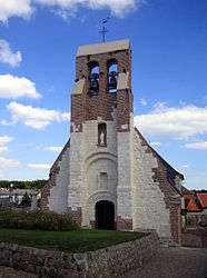
- Church of Saint Cyr and Sainte-Julitte. Recently restored in the 21st century.
- The war memorial, at the entrance to the graveyard.
.jpg)
The war memorial
See also
References
External links
| Wikimedia Commons has media related to Pont-de-Metz. |
- Municipal website (French)
- Pont-de-Metz on the Quid website (French)
This article is issued from Wikipedia - version of the 11/8/2016. The text is available under the Creative Commons Attribution/Share Alike but additional terms may apply for the media files.