Grattepanche
| Grattepanche | |
|---|---|
 | |
 Grattepanche | |
|
Location within Hauts-de-France region  Grattepanche | |
| Coordinates: 49°47′17″N 2°17′41″E / 49.7881°N 2.2947°ECoordinates: 49°47′17″N 2°17′41″E / 49.7881°N 2.2947°E | |
| Country | France |
| Region | Hauts-de-France |
| Department | Somme |
| Arrondissement | Amiens |
| Canton | Boves |
| Intercommunality | Amien Métropole |
| Government | |
| • Mayor (2001–2008) | Maurice Navarre |
| Area1 | 6.43 km2 (2.48 sq mi) |
| Population (2006)2 | 291 |
| • Density | 45/km2 (120/sq mi) |
| Time zone | CET (UTC+1) |
| • Summer (DST) | CEST (UTC+2) |
| INSEE/Postal code | 80387 / 80680 |
| Elevation |
69–125 m (226–410 ft) (avg. 100 m or 330 ft) |
|
1 French Land Register data, which excludes lakes, ponds, glaciers > 1 km² (0.386 sq mi or 247 acres) and river estuaries. 2 Population without double counting: residents of multiple communes (e.g., students and military personnel) only counted once. | |
Grattepanche is a commune in the Somme department in Hauts-de-France in northern France.
Geography
Grattepanche is situated on the D75e road, some 10 miles (16 km) south of Amiens.
Population
| Year | 1962 | 1968 | 1975 | 1982 | 1990 | 1999 | 2006 |
|---|---|---|---|---|---|---|---|
| Population | 87 | 120 | 148 | 179 | 243 | 269 | 291 |
| From the year 1962 on: No double counting—residents of multiple communes (e.g. students and military personnel) are counted only once. | |||||||
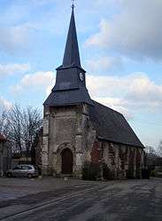
Places of interest
- The church
- The war memorial
- The calvary
See also
References
External links
| Wikimedia Commons has media related to Grattepanche. |
- Official municipal website (French)
- Grattepanche on the Quid website (French)
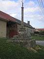 The calvary
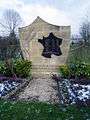 The war memorial
This article is issued from Wikipedia - version of the 11/8/2016. The text is available under the Creative Commons Attribution/Share Alike but additional terms may apply for the media files.