Crawfordsville, Indiana
| Crawfordsville, Indiana | |
|---|---|
| City | |
|
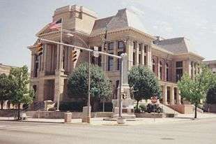
Montgomery County Courthouse, 1997 | |
| Nickname(s): Athens of Indiana (William Compton, 1825)[1] | |
 Crawfordsville, Indiana Crawfordsville's location in Montgomery County | |
| Coordinates: 40°2′20″N 86°53′48″W / 40.03889°N 86.89667°WCoordinates: 40°2′20″N 86°53′48″W / 40.03889°N 86.89667°W | |
| Country | United States |
| State | Indiana |
| County | Montgomery |
| Township | Union |
| Government | |
| • Mayor | Todd Barton (R) |
| Area[2] | |
| • Total | 9.15 sq mi (23.70 km2) |
| • Land | 9.15 sq mi (23.70 km2) |
| • Water | 0 sq mi (0 km2) |
| Elevation | 787 ft (240 m) |
| Population (2010)[3] | |
| • Total | 15,915 |
| • Estimate (2012[4]) | 16,015 |
| • Density | 1,739.3/sq mi (671.5/km2) |
| Time zone | EST (UTC-5) |
| • Summer (DST) | EDT (UTC-4) |
| ZIP codes | 47933-47939 |
| Area code(s) | 765 |
| FIPS code | 18-15742[5] |
| GNIS feature ID | 0433103[6] |
| Website | crawfordsville.net |
Crawfordsville is a city in Union Township, Montgomery County, Indiana, United States. As of the 2010 census, the city had a population of 15,915. The city is the county seat of Montgomery County.[7] It is home to Wabash College, which was ranked by Forbes as #12 in the United States for undergraduate studies in 2008.[8]
History
National Register of Historic Places
As of 2016, Crawfordsville has twelve properties listed on the National Register of Historic Places. Three of the properties are currently museums: Gen. Lew Wallace Study, Henry S. Lane House, and Montgomery County Jail and Sheriff's Residence. Two of the properties are historic districts: Crawfordsville Commercial Historic District, and Elston Grove Historic District. Two listings are active churches: Bethel AME Church of Crawfordsville, and Saint John's Episcopal Church. The others properties are currently used as a law office (Otto Schlemmer Building), senior apartments and recreation center (Crawfordsville High School), a private residence (McClelland-Layne House), the headquarters of the local Daughters of the American Revolution chapter (Col. Isaac C. Elston House), and a former hospital renovated for senior apartments Culver Union Hospital.[9]
Early 19th century

In 1813, Williamson Dunn, Henry Ristine, and Major Ambrose Whitlock noted that the site of present-day Crawfordsville was ideal for settlement, surrounded by deciduous forest and potentially arable land, with water provided by a nearby creek, later named Sugar Creek. They returned a decade later to find at least one cabin built. In 1821, William and Jennie Offield had built a cabin on a little creek, later to be known as Offield Creek, four miles southwest of the future site of Crawfordsville.
Major Whitlock laid out the town in March 1823. Crawfordsville was named in honor of Colonel William H. Crawford, a native Virginian who was the cabinet officer who had issued Whitlock's commission as Receiver of Public Lands.[1][10]
According to a diary of Sanford C. Cox, one of the first schoolmasters in the area, in 1824: "Crawfordsville is the only town between Terre Haute and Fort Wayne... Maj. Ristine keeps tavern in a two-story log house and Jonathan Powers has a little grocery. There are two stores, Smith's near the land office, and Issac C. Elston's, near the tavern... David Vance [is the] sheriff.[11]
It was successfully incorporated as a town in 1834, following a failed attempt three years earlier.
In November 1832, Wabash College was founded in Crawfordsville as "The Wabash Teachers Seminary and Manual Labor College". On December 18, 1833, the Crawfordsville Record carried a paid announcement of the opening of this school.[1]
Today, it is one of only three remaining all-male liberal arts colleges in the country, and has a student body of around 900.
Crawfordsville grew in size and amenities, adding such necessities as a bank and fire department. It gained status as a city in 1865, when Indiana granted its charters.
Late 19th century
In 1862, Joseph F. Tuttle, after whom Tuttle Grade School was named in 1906 and Tuttle Junior High School (now Crawfordsville Middle School) was named in 1960, became President of Wabash College and served for 30 years. "He was an eloquent preacher, a sound administrator and an astute handler of public relations." Joseph Tuttle, together with his administrators, worked to improve relations in Crawfordsville between "Town and Gown".[1]
Several future and past Civil War generals lived in Crawfordsville at different times. Generals Lew Wallace and Mahlon D. Manson spent most their lives in the town. Generals Edward Canby and John P. Hawkins spent some of their youth in Crawfordsville. General Henry B. Carrington lived in the town after the war, and taught military science at Wabash College. Several other future generals were students at Wabash before the war, including Joseph J. Reynolds, John C. Black (brevet brigadier), Speed S. Fry, Charles Cruft, and William H. Morgan.[12]
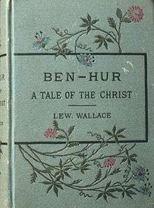
In 1880, prominent local citizen Lew Wallace produced Crawfordsville's most famous literary work, Ben-Hur: A Tale of the Christ, a historical novel dealing with the beginnings of Christianity in the Mediterranean world. In addition to Wallace, Crawfordsville lived up to its nickname "The Athens of Indiana" by being the hometown of a number of authors, including Maurice Thompson, Mary Hannah Krout, Caroline Virginia Krout, Susan Wallace, Will H. Thompson, and Meredith Nicholson.
Hoosiers have long believed that the first basketball game in Indiana occurred in Crawfordsville YMCA between the teams from Crawfordsville's and Lafayette's YMCAs on March 16, 1894. Recent research, however, conclusively shows that while Crawfordsville was among the first dozen or so Indiana communities to adopt the sport, it was not the first place basketball was played in Indiana.[13] Nevertheless, Crawfordsville had a vibrant basketball playing culture from early on with teams from the local YMCA, Wabash College, Crawfordsville High School, and a business college competing against each other. Crawfordsville was also the site for one of the earliest intercollegiate basketball games between Wabash and Purdue in 1894 at the city's YMCA.
In 1882, one of the first Rotary Jails in the country opened. It served from 1882 until 1972. The jail is now a museum and listed on the National Register of Historic Places.
20th century

The beginning of the 20th century marked important steps for Crawfordsville, as Culver Union Hospital and the Carnegie Library were built in 1902. Culver operated as a not-for-profit, municipally-owned facility for 80 years, was then sold to for-profit American Medical International, and in 1984 was relocated from its original location near downtown to a new campus north of the city. The hospital's ownership was transferred to Sisters of St. Francis Health Services, Inc. in 2000 and renamed St. Clare Medical Center; in 2011, it was again renamed Franciscan St. Elizabeth Health - Crawfordsville. The Carnegie Library was converted into a local museum and the public library has since moved across the street. In 1911, Crawfordsville High School (motto: Enter to Learn, Go Forth to Serve) was founded, and promptly won the state's first high school basketball title.[14] Crawfordsville's major employer for much of the century, commercial printer RR Donnelley, began operations in Crawfordsville in 1922.
Recent history has held few nationally noteworthy events for the city, but much internal change. Nucor Steel, Alcoa CSI, Raybestos Products Company, Pace Dairy Foods, and Random House have all created factories in or near Crawfordsville which provided employment to much of the population. Manpower has taken over as the primary employer in the city and has allowed most of the local companies to reduce employees. In 2008, Raybestos laid off the majority of its workforce with less than 100 employees left. Wabash College won the Division III NCAA basketball title in 1982. The college plays an annual football game against Depauw University for the Monon Bell, one of the oldest rivalries in all college sports. In 1998, the state began a proposed project to widen U.S. Route 231, in an attempt to ease intrastate travel flow.
21st century
In 2005, the Crawfordsville District Public Library moved into a new building across the street from the city's Carnegie library. The library retained ownership of the old building and re-opened it as the Carnegie Museum of Montgomery County in 2007.
On May 8, 2007, approximately a quarter-block of historic buildings in the 100 block of South Washington Street was burned in a major fire. A woman in one of the buildings reported the fire. One person, Leslie Eric Largent, died in the fire. The fire was covered by the press statewide. Two buildings, built circa 1882, were completely destroyed: one that housed the Silver Dollar Bar (formerly Tommy Kummings' Silver Dollar Tavern); the other contained the New York Shoe Repair and Bargain Center at the corner of Pike and Washington streets. Above the shoe store were several apartments where residents were sleeping. On May 22, the fire was ruled to have been an act of arson.[15]
In 2015, Crawfordsville won a Stellar Community grant from Indiana Office of Community & Rural Affairs.[16]
Local legend
An alleged monster was seen here in the late 19th century that became known as the Crawfordsville monster. It was described to be made of a cloud with red glowing eyes. It is now believed to have been a flock of birds huddled together in confusion due to the town's newly installed electric street lights. The story was featured in The History Channel's television series Monster Quest, in an episode featuring unidentified flying creatures.
Mayors
- Wilson H. Laymon, 1865-1868
- John Speed, 1868-1870
- W. Frank Elston, 1870-1872
- Wilson H. Laymon, 1872
- John R. Coons, August 1872-1878
- John W. Ramsay (R), 1878-1884
- Thomas L. Stilwell (R), 1884-86
- Byron R. Russell (R), 1886-1890
- William C. Carr (R), 1890-1892
- Fred C. Bandle (R), 1892-1896
- Thomas L. Stilwell (R), 1896-1898
- Charles W. Elmore (R), 1898-1902
- Byron R. Russell (R), 1902-1904
- Samuel E. Voris (D), 1904-1910
- Martin V. Wert (R), 1910-1914 [17]
- William C. Murphy (D), 1914-1918
- Dumont Kennedy (R), 1918-1920 [18]
- D. Earl Berry (D), 1921-1925 [19]
- Dumont Kennedy (R), 1926-1929 (second term, non-consecutive)
- Dr. Thomas L. Cooksey (R), 1930-1934 [20]
- Dr. Bertrand E. May (R), 1935-1939 [21]
- Dr. Thomas L. Cooksey (R), 1940-1947 [22] (served three terms, two were five year terms and non-consecutive, in office for 14 total years)
- Clark D. Jones (R), 1948-1951
- Carroll O. Beeson (R), 1952-1955 [23]
- Paul Stump (D), 1956-1959 [24]
- Carl F. Henthorn (R), 1960-63 [25]
- William H. Hays, Jr. (R), 1964-1971
- David G Gerard (R), 1972-1975 [26]
- Glenn J. Knecht (D), 1976-1987 [27] (three terms)
- Philip Q. Michal (R), 1988-1999 (three terms)
- Stephen D. Gentry (R), 2000-2003
- John P. Zumer (D), 2004-2007 (resigned before term expired)
- Charles E. Coons (D), 2007-2011 (assumed Zumer's unexpired term, and won election to full term)
- Todd Barton (R), 2012-
Geography
Crawfordsville is located at 40°2′20″N 86°53′48″W / 40.03889°N 86.89667°W (40.038831, -86.896755).[28] According to the 2010 census, Crawfordsville has a total area of 9.15 square miles (23.70 km2), all land.[2] Crawfordsville is located in west central Indiana, about an hour west-northwest of Indianapolis, the state's capital and largest city. While the Crawfordsville Micropolitan Area is not yet formally a part of the Indianapolis Metropolitan Area, it is considered a part of the wider Indianapolis Consolidated Metropolitan Statistical Area and the Indianapolis marketing area.
Demographics
| Historical population | |||
|---|---|---|---|
| Census | Pop. | %± | |
| 1840 | 1,327 | — | |
| 1850 | 1,513 | 14.0% | |
| 1860 | 1,922 | 27.0% | |
| 1870 | 3,701 | 92.6% | |
| 1880 | 5,251 | 41.9% | |
| 1890 | 6,089 | 16.0% | |
| 1900 | 6,649 | 9.2% | |
| 1910 | 9,371 | 40.9% | |
| 1920 | 10,139 | 8.2% | |
| 1930 | 10,355 | 2.1% | |
| 1940 | 11,089 | 7.1% | |
| 1950 | 12,851 | 15.9% | |
| 1960 | 14,231 | 10.7% | |
| 1970 | 13,842 | −2.7% | |
| 1980 | 13,325 | −3.7% | |
| 1990 | 13,584 | 1.9% | |
| 2000 | 15,243 | 12.2% | |
| 2010 | 15,915 | 4.4% | |
| Est. 2015 | 16,024 | [29] | 0.7% |
| U.S. Decennial Census | |||
2010 census
As of the census[3] of 2010, there were 15,915 people, 6,396 households, and 3,837 families residing in the city. The population density was 1,739.3 inhabitants per square mile (671.5/km2). There were 7,154 housing units at an average density of 781.9 per square mile (301.9/km2). The racial makeup of the city was 92.1% White, 1.7% African American, 0.4% Native American, 0.9% Asian, 3.3% from other races, and 1.6% from two or more races. Hispanic or Latino of any race were 8.2% of the population.
There were 6,396 households of which 30.3% had children under the age of 18 living with them, 40.8% were married couples living together, 13.6% had a female householder with no husband present, 5.6% had a male householder with no wife present, and 40.0% were non-families. 33.7% of all households were made up of individuals and 14% had someone living alone who was 65 years of age or older. The average household size was 2.31 and the average family size was 2.91.
The median age in the city was 36.6 years. 22.3% of residents were under the age of 18; 13.4% were between the ages of 18 and 24; 24% were from 25 to 44; 23.4% were from 45 to 64; and 16.9% were 65 years of age or older. The gender makeup of the city was 50.1% male and 49.9% female.
2000 census
As of the 2000 census,[5] there were 15,243 people, 6,117 households, and 3,664 families residing in the city. The population density was 1,819.4 people per square mile (702.3/km²). There were 6,623 housing units at an average density of 790.5 per square mile (305.1/km²). The racial makeup of the city was 94.02% White, 1.61% African American, 0.31% Native American, 0.70% Asian, 0.07% Pacific Islander, 2.39% from other races, and 0.91% from two or more races. Hispanic or Latino of any race were 3.25% of the population.
There were 6,117 households out of which 29.2% had children under the age of 18 living with them, 45.0% were married couples living together, 11.2% had a female householder with no husband present, and 40.1% were non-families. 33.9% of all households were made up of individuals and 14.5% had someone living alone who was 65 years of age or older. The average household size was 2.30 and the average family size was 2.94.
In the city, the population was spread out with 23.3% under the age of 18, 13.4% from 18 to 24, 27.3% from 25 to 44, 19.6% from 45 to 64, and 16.5% who were 65 years of age or older. The median age was 35 years. For every 100 females there were 98.8 males. For every 100 females age 18 and over, there were 97.1 males.
The median income for a household in the city was $34,571, and the median income for a family was $43,211. Males had a median income of $32,834 versus $22,093 for females. The per capita income for the city was $16,945. About 10.0% of families and 12.9% of the population were below the poverty line, including 18.9% of those under age 18 and 7.0% of those age 65 or over.
Industry
Crawfordsville is the home of the world's first thin-slab casting minimill (steel manufacturing plant that recycles scrap steel using an electric arc-furnace). Nucor Steel broke ground on its first sheet steel mill and first galvanizing line at its billion-dollar Crawfordsville facility in 1987.
Education
Most of the city lies within the Crawfordsville Community Schools school district, while parts of northern Crawfordsville are in North Montgomery Community School Corporation and very small sections of south Crawfordsville are in South Montgomery Community School Corporation.[30]
Transportation
Rail
Currently, Amtrak provides service to Crawfordsville. Amtrak Train 51, the westbound Cardinal, is scheduled to depart Crawfordsville at 7:28 am on Monday, Thursday, and Saturday; Amtrak Train 851, the westbound Hoosier State, is scheduled to depart Crawfordsville at 7:28 am on Sunday, Tuesday, Wednesday, and Friday. Both trains go to Lafayette, Rensselaer, Dyer and Chicago Union Station to connect with other trains.
Amtrak Train 50, the eastbound Cardinal, is scheduled to depart Dyer at 10:30 pm on Tuesday, Thursday, and Saturday with service to Indianapolis, Connersville, Cincinnati, Maysville, South Portsmouth, Ashland, Huntington, Charleston, Montgomery, Thurmond, Prince, Hinton, Alderson, White Sulphur Springs, Clifton Forge, Staunton, Charlottesville, Culpeper, Manassas, Alexandria, and Washington, D.C. and continuing on to New York City.
Amtrak Train 850, the eastbound Hoosier State, is scheduled to depart Dyer at 10:30 pm on Sunday, Monday, Wednesday, and Friday with service to Indianapolis.
Until 1967, passenger service was provided by the Monon Railroad, providing service to Chicago, Lafayette, Greencastle and Bloomington, Indiana. The Monon railroad was merged into the Louisville and Nashville Railroad in 1971.
Airport
- KCFJ - Crawfordsville Municipal
Crawfordsville is served by the Crawfordsville Municipal Airport (KCFJ). Located four miles south of the city, the airport handles approximately 6,383 operations per year, with 100% general aviation and <1% air taxi. The airport has a 4,504 foot asphalt runway with approved GPS and NDB approaches (Runway 4-22).[31]
Notable people
- Joseph P. Allen - mission specialist on the first fully operational flight of the Space Shuttle in 1982
- Albert Barnes Anderson - Judge for U.S. District Court 1902-25 & U.S. Court of Appeals 1925-38
- "Curly Bill" Brocius - Old West outlaw, evidence stating his birthplace as Crawfordsville is tenuous
- Edward Richard Sprigg Canby - Union general in the American Civil War
- Henry Beebee Carrington - Union general during the Civil War
- Joseph Stephen Crane - restaurateur of Luau and Kon Tiki restaurants; actor; husband to actresses Lana Turner (1942–44) and Martine Carol (1948–53)
- Sidney and Wilbur de Paris - brothers, jazz musicians
- Beatrice Schenk de Regniers - children's books author
- Leroy Edwards - 1940s University of Kentucky and professional basketball player
- Isaac Compton Elston, Sr. - land speculator, banker, patriarch of Crawfordsville's pre-eminent family
- Dave Gerard - cartoonist created "Will-Yum" and "Citizen Smith", also served as Crawfordsville mayor
- Bayless W. Hanna - Indiana Attorney General (1870–72), U.S. Minister to Argentina (1885–89), publisher of the Crawfordsville Review (1883–85)
- John Parker Hawkins - lived in Crawfordsville as a boy, career Army officer, became a Union brigadier general during the Civil War
- Bill Holman - cartoonist, creator of Smokey Stover
- James Brian Hellwig (1959-2014) - professional wrestler, best known as The Ultimate Warrior
- Kent Kessler - avant garde jazz bassist
- Caroline Virginia Krout - author
- Mary Hannah Krout - journalist and author
- Eleanor Lambert - head of NYC Fashion Institute, sister of Ward Lambert
- Janet Lambert - author of young adult fiction
- Ward Lambert - Purdue University's basketball coach from 1916–1917, 1918–1946, National Basketball League Commissioner, Naismith Basketball Hall of Fame member, brother of Eleanor Lambert
- Henry S. Lane - United States Senator, Governor of Indiana, and pallbearer for Abraham Lincoln
- Stephen A. Love - musician
- Mahlon D. Manson - Union Army brigadier general, Indiana Lieutenant Governor (1885–86), U.S. Representative (1871–73)
- James W. Marshall - gold miner who set off the California Gold Rush.
- Joseph E. McDonald - lawyer, U.S. Representative (1849–50), U.S. Senator (1875-81)
- Pete Metzelaars - played football and basketball for Wabash College; professional football player and coach that included stints with the Seattle Seahawks, Buffalo Bills, Carolina Panthers, and Detroit Lions in a sixteen-year career in the National Football League.
- Caleb Mills - author of the free school bill of Indiana, State Superintendent of Public Instruction, first professor at Wabash College
- James Atwell Mount - Governor of Indiana from 1897–1901
- Kenyon Nicholson - playwright and screenwriter
- Meredith Nicholson - author (The House of a Thousand Candles, A Hoosier Chronicle), politician, diplomat
- Robert B. F. Peirce - U.S. Representative (1881–83)
- Allen Saunders - cartoonist, wrote Steve Roper, and Mary Worth
- Ferdinand Louis Schlemmer - artist
- Will Shortz - The New York Times puzzle writer
- Maurice Thompson - author, poet, naturalist, State Geologist, popularized archery as a sport
- William Wheeler Thornton - author, State Supreme Court librarian, Indiana Deputy Attorney General, Crawfordsville City Attorney
- Randal Turner - opera singer; baritone
- Dick Van Dyke - actor, briefly attended Tuttle Middle School in Crawfordsville
- Lew Wallace - Union general in the Civil War and author of Ben-Hur; Governor of New Mexico Territory from 1878 to 1881; served as U.S. Minister to the Ottoman Empire from 1881 to 1885.
- Susan Wallace - author and poet, wife of Lew Wallace
- Maurine Dallas Watkins - author of Chicago; Hollywood screenwriter
- Howdy Wilcox - Indianapolis 500 racing pioneer, winner of the 1919 Indy 500
- Henry Lane Wilson - U.S. diplomat and Ambassador to Mexico, son of James Wilson
- James Wilson - politician, United States Representative from Indiana and United States Ambassador to Venezuela
- John L. Wilson - politician, United States Representative and Senator from Washington, son of James Wilson
Footnotes
- 1 2 3 4 Gronert, Theodore G., Sugar Creek Saga: A History and Development of Montgomery County, Wabash College, 1958.
- 1 2 "G001 - Geographic Identifiers - 2010 Census Summary File 1". United States Census Bureau. Retrieved 2015-07-28.
- 1 2 "American FactFinder". United States Census Bureau. Retrieved 2012-12-11.
- ↑ "Population Estimates". United States Census Bureau. Archived from the original on 2013-06-17. Retrieved 2013-06-25.
- 1 2 "American FactFinder". United States Census Bureau. Archived from the original on 2013-09-11. Retrieved 2008-01-31.
- ↑ "US Board on Geographic Names". United States Geological Survey. 2007-10-25. Retrieved 2008-01-31.
- ↑ "Find a County". National Association of Counties. Archived from the original on 2011-05-31. Retrieved 2011-06-07.
- ↑ Hewitt, Howard W. (August 14, 2008). "Forbes: Wabash Nation's 12th Best". Crawfordsville News.
- ↑ National Park Service (2010-07-09). "National Register Information System". National Register of Historic Places. National Park Service.
- ↑ Ronald L. Baker and Marvin Carmony: Indiana Place Names, Indiana University Press, Bloomington, Ind., 1975, p. 35.
- ↑ History of Montgomery County, together with historic notes on the Wabash Valley, gleaned from early authors, old maps and manuscripts, private and official correspondence, and other authentic ... sources. Author: Beckwith, Hiram Williams, 1833-1903. Published: Chicago : H.H. Hill and N. Iddings, 1881. pg. 117
- ↑ Historical Marker Database image of plaque on Wabash College campus
- ↑ "Indiana Magazine of History looks for the origins of Hoosier basketball"
- ↑ Montgomery County Historical Society Profiles: the First High School Basketball Champion
- ↑ Indianapolis Star article
- ↑ WLFI news story
- ↑ A. W. Bowen, History of Montgomery County, Indiana vol. 1, (Indianapolis: A. W. Bowen, 1913). This source lists all of Crawfordsville's mayors up to 1913.
- ↑ Crawfordsville Review
- ↑ Berry Find-a-Grave
- ↑ Political Graveyard
- ↑ "crawfordsville+mayor"------ Greencastle Daily Banner
- ↑ Political Graveyard
- ↑ Political Graveyard
- ↑ Political Graveyard
- ↑ Crawfordsville Journal-Review Obit
- ↑ Syracuse University Library Finding Aid on Gerard
- ↑ Indiana Football HOF bio
- ↑ "US Gazetteer files: 2010, 2000, and 1990". United States Census Bureau. 2011-02-12. Retrieved 2011-04-23.
- ↑ "Annual Estimates of the Resident Population for Incorporated Places: April 1, 2010 to July 1, 2015". Retrieved July 2, 2016.
- ↑ "SCHOOL DISTRICT REFERENCE MAP (2010 CENSUS): Montgomery County, IN." U.S. Census Bureau. Retrieved on Novembe 26, 2016.
- ↑ http://www.airnav.com/airports/cfj
External links
- City of Crawfordsville
- Community Profile
- Crawfordsville District Public Library
- Crawfordsville Star, Google news archive. —PDFs of 1,180 issues, dating from 1872 through 1898.
- Daily News-Review, Google news archive. —PDFs of 1,050 issues, dating from 1900 through 1903.
- Crawfordsville Review, Google news archive. —PDFs of 765 issues, dating from 1911 through 1928.
| Wikimedia Commons has media related to Crawfordsville, Indiana. |
Municipalities and communities of Montgomery County, Indiana, United States | ||
|---|---|---|
| City | ||
| Towns | ||
| Townships | ||
| CDP | ||
| Other unincorporated communities |
| |
