Harrison, Nebraska
| Harrison, Nebraska | |
|---|---|
| Village | |
|
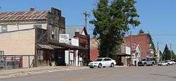
Main Street | |
 Location within Sioux County and Nebraska | |
| Coordinates: 42°41′17″N 103°52′56″W / 42.68806°N 103.88222°WCoordinates: 42°41′17″N 103°52′56″W / 42.68806°N 103.88222°W | |
| Country | United States |
| State | Nebraska |
| County | Sioux |
| Area[1] | |
| • Total | 0.31 sq mi (0.80 km2) |
| • Land | 0.31 sq mi (0.80 km2) |
| • Water | 0 sq mi (0 km2) |
| Elevation | 4,865 ft (1,483 m) |
| Population (2010)[2] | |
| • Total | 251 |
| • Estimate (2012[3]) | 249 |
| • Density | 810/sq mi (310/km2) |
| Time zone | Mountain (MST) (UTC-7) |
| • Summer (DST) | MDT (UTC-6) |
| ZIP code | 69346 |
| Area code(s) | 308 |
| FIPS code | 31-21240 [4] |
| GNIS feature ID | 0829824 [5] |
Harrison is a village in Sioux County, Nebraska, United States. The population was 251 at the 2010 census. It is the county seat of Sioux County.[6]
History
Harrison was originally called Bowen, and under that name was platted in 1886, when the Fremont, Elkhorn, & Missouri Valley Railroad was extended to that point.[7] It was renamed Harrison in 1887, in honor of Benjamin Harrison.[8][9] Harrison was incorporated in 1889.[10]
Geography
Harrison is located at 42°41′17″N 103°52′56″W / 42.68806°N 103.88222°W (42.687984, -103.882115),[11] on the American Great Plains. According to the United States Census Bureau, the village has a total area of 0.31 square miles (0.80 km2), all land.[1]
At 4,876 feet (1,486 m), Harrison has the highest elevation of any town in Nebraska, prompting it to bill itself as "Nebraska's Top Town".[12]
The area around Harrison largely consists of grass-covered plains. Grasses and other flora present include little bluestem, prairie sandreed, blue grama, and needle and thread grass. Wildflowers in the area include lupin, spiderwort, western wallflower, and sunflowers.[13]
Demographics
| Historical population | |||
|---|---|---|---|
| Census | Pop. | %± | |
| 1890 | 111 | — | |
| 1900 | 168 | 51.4% | |
| 1910 | 186 | 10.7% | |
| 1920 | 401 | 115.6% | |
| 1930 | 480 | 19.7% | |
| 1940 | 500 | 4.2% | |
| 1950 | 492 | −1.6% | |
| 1960 | 448 | −8.9% | |
| 1970 | 377 | −15.8% | |
| 1980 | 361 | −4.2% | |
| 1990 | 291 | −19.4% | |
| 2000 | 279 | −4.1% | |
| 2010 | 251 | −10.0% | |
| Est. 2015 | 238 | [14] | −5.2% |
2010 census
As of the census[2] of 2010, there were 251 people, 134 households, and 69 families residing in the village. The population density was 809.7 inhabitants per square mile (312.6/km2). There were 186 housing units at an average density of 600.0 per square mile (231.7/km2). The racial makeup of the village was 98.4% White and 1.6% from two or more races. Hispanic or Latino of any race were 1.6% of the population.
There were 134 households of which 20.1% had children under the age of 18 living with them, 41.8% were married couples living together, 6.7% had a female householder with no husband present, 3.0% had a male householder with no wife present, and 48.5% were non-families. 47.0% of all households were made up of individuals and 23.9% had someone living alone who was 65 years of age or older. The average household size was 1.87 and the average family size was 2.67.
The median age in the village was 50.7 years. 19.5% of residents were under the age of 18; 4.9% were between the ages of 18 and 24; 20.4% were from 25 to 44; 27.2% were from 45 to 64; and 28.3% were 65 years of age or older. The gender makeup of the village was 46.6% male and 53.4% female.
2000 census
As of the census[4] of 2000, there were 279 people, 137 households, and 80 families residing in the village. The population density was 905.5 people per square mile (347.5/km²). There were 179 housing units at an average density of 580.9 per square mile (222.9/km²). The racial makeup of the village was 98.92% White, 0.36% from other races, and 0.72% from two or more races. Hispanic or Latino of any race were 0.72% of the population.
There were 137 households out of which 16.1% had children under the age of 18 living with them, 44.5% were married couples living together, 12.4% had a female householder with no husband present, and 41.6% were non-families. 40.9% of all households were made up of individuals and 24.1% had someone living alone who was 65 years of age or older. The average household size was 2.04 and the average family size was 2.68.
In the village the population was spread out with 17.9% under the age of 18, 8.6% from 18 to 24, 17.9% from 25 to 44, 27.6% from 45 to 64, and 28.0% who were 65 years of age or older. The median age was 48 years. For every 100 females there were 93.8 males. For every 100 females age 18 and over, there were 80.3 males.
As of 2000 the median income for a household in the village was $29,375, and the median income for a family was $29,688. Males had a median income of $25,500 versus $21,250 for females. The per capita income for the village was $15,071. About 11.8% of families and 18.6% of the population were below the poverty line, including 33.8% of those under the age of eighteen and 10.8% of those sixty five or over.
Climate
| Climate data for Harrison, Nebraska (Elevation 4,865ft) | |||||||||||||
|---|---|---|---|---|---|---|---|---|---|---|---|---|---|
| Month | Jan | Feb | Mar | Apr | May | Jun | Jul | Aug | Sep | Oct | Nov | Dec | Year |
| Record high °F (°C) | 65 (18) |
69 (21) |
79 (26) |
86 (30) |
98 (37) |
103 (39) |
107 (42) |
102 (39) |
100 (38) |
89 (32) |
76 (24) |
73 (23) |
107 (42) |
| Average high °F (°C) | 33.4 (0.8) |
37.6 (3.1) |
44.6 (7) |
55.0 (12.8) |
65.2 (18.4) |
76.2 (24.6) |
85.7 (29.8) |
84.1 (28.9) |
73.8 (23.2) |
60.8 (16) |
45.1 (7.3) |
36.1 (2.3) |
58.1 (14.5) |
| Average low °F (°C) | 9.8 (−12.3) |
13.7 (−10.2) |
20.0 (−6.7) |
29.0 (−1.7) |
38.8 (3.8) |
48.4 (9.1) |
55.2 (12.9) |
53.0 (11.7) |
42.9 (6.1) |
31.9 (−0.1) |
20.6 (−6.3) |
12.6 (−10.8) |
31.3 (−0.4) |
| Record low °F (°C) | −33 (−36) |
−35 (−37) |
−20 (−29) |
−10 (−23) |
5 (−15) |
23 (−5) |
34 (1) |
32 (0) |
3 (−16) |
−12 (−24) |
−20 (−29) |
−39 (−39) |
−39 (−39) |
| Average precipitation inches (mm) | 0.49 (12.4) |
0.51 (13) |
1.13 (28.7) |
2.24 (56.9) |
3.32 (84.3) |
2.87 (72.9) |
2.06 (52.3) |
1.38 (35.1) |
1.37 (34.8) |
1.15 (29.2) |
0.67 (17) |
0.50 (12.7) |
17.70 (449.6) |
| Average snowfall inches (cm) | 7.0 (17.8) |
7.3 (18.5) |
11.7 (29.7) |
9.6 (24.4) |
1.9 (4.8) |
0.1 (0.3) |
0 (0) |
0 (0) |
0.7 (1.8) |
3.2 (8.1) |
6.4 (16.3) |
7.0 (17.8) |
54.8 (139.2) |
| Source: The Western Regional Climate Center[16] | |||||||||||||
Area attractions
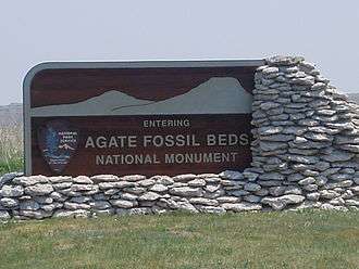
Agate Fossil Beds National Monument, maintained by the National Park Service is 25 minutes south of Harrison on River Road, Nebraska State Route 29. The site is best known for the large number of well-preserved Miocene mammal fossils on display, which date from about 20 million years ago, and are among some of the best specimens of Miocene mammals. The monument's museum collection also contains more than 500 items from the Cook Collection of Plains Indian artifacts, originally from the Agate Springs Ranch, a working cattle ranch, owned by Harold J. Cook. The Cook Homestead (Bone Cabin Complex) is listed on the National Register of Historic Places.[17]
Highways
 U.S. Highway 20 - east-west route through Harrison (Bridges to Buttes Byway)
 N-29 Nebraska Route 29 - route going south out of Harrison (Main St)
Notable people
- Dwight Griswold, Governor of Nebraska from 1940 to 1946, and U.S. Senator from 1952 to 1954, was born in Harrison.[18]
References
- 1 2 "US Gazetteer files 2010". United States Census Bureau. Retrieved 2012-06-24.
- 1 2 "American FactFinder". United States Census Bureau. Retrieved 2012-06-24.
- ↑ "Population Estimates". United States Census Bureau. Retrieved 2013-05-29.
- 1 2 "American FactFinder". United States Census Bureau. Retrieved 2008-01-31.
- ↑ "US Board on Geographic Names". United States Geological Survey. 2007-10-25. Retrieved 2008-01-31.
- ↑ "Find a County". National Association of Counties. Retrieved 2011-06-07.
- ↑ "Harrison, Sioux County". Center for Advanced Land Management Information Technologies. University of Nebraska. Retrieved 23 August 2014.
- ↑ Fitzpatrick, Lillian L. (1960). Nebraska Place-Names. University of Nebraska Press. p. 137. ISBN 0-8032-5060-6. A 1925 edition is available for download at University of Nebraska—Lincoln Digital Commons.
- ↑ "Sioux County, Nebraska". NEGenWeb Project. Retrieved 24 August 2014.
- ↑ Shumway, Grant Lee (1921). History of Western Nebraska and Its People. Western publishing & engraving Company. p. 281.
- ↑ "US Gazetteer files: 2010, 2000, and 1990". United States Census Bureau. 2011-02-12. Retrieved 2011-04-23.
- ↑ "Nebraska's 'Top Town'". Sioux County Travel and Tourism website. Retrieved 2010-08-31.
- ↑ "Agate Fossil Beds National Monument". U.S. National Park Service. Archived from the original on December 2, 2009. Retrieved July 5, 2015.
- ↑ "Annual Estimates of the Resident Population for Incorporated Places: April 1, 2010 to July 1, 2015". Retrieved July 2, 2016.
- ↑ "Census of Population and Housing". Census.gov. Retrieved June 4, 2015.
- ↑ "Seasonal Temperature and Precipitation Information". Western Regional Climate Center. Retrieved July 30, 2013.
- ↑ "Nebraska National Register Sites in Sioux County". Nebraska State Historical Society. Archived from the original on November 18, 2013. Retrieved October 18, 2013.
- ↑ "GRISWOLD, Dwight Palmer, (1893 - 1954)". Biographical Directory of the United States Congress. Retrieved October 6, 2012.
External links
Municipalities and communities of Sioux County, Nebraska, United States | ||
|---|---|---|
| Village | ||
| Unincorporated communities | ||