Valley Grove, West Virginia
| Valley Grove, West Virginia | |
|---|---|
| Village | |
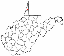 Location of Valley Grove, West Virginia | |
| Coordinates: 40°5′16″N 80°34′7″W / 40.08778°N 80.56861°WCoordinates: 40°5′16″N 80°34′7″W / 40.08778°N 80.56861°W | |
| Country | United States |
| State | West Virginia |
| County | Ohio |
| Area[1] | |
| • Total | 0.55 sq mi (1.42 km2) |
| • Land | 0.55 sq mi (1.42 km2) |
| • Water | 0 sq mi (0 km2) |
| Elevation | 932 ft (284 m) |
| Population (2010)[2] | |
| • Total | 378 |
| • Estimate (2012[3]) | 377 |
| • Density | 687.3/sq mi (265.4/km2) |
| Time zone | Eastern (EST) (UTC-5) |
| • Summer (DST) | EDT (UTC-4) |
| ZIP code | 26060 |
| Area code(s) | 304 |
| FIPS code | 54-82732[4] |
| GNIS feature ID | 1555869[5] |
Valley Grove is a village in Ohio County, West Virginia, United States. It is part of the Wheeling, West Virginia Metropolitan Statistical Area. The population was 378 at the 2010 census. The village was named from a nearby recreational area at a grove in a valley.[6][7]
Geography
Valley Grove is located at 40°05′16″N 80°34′07″W / 40.087902°N 80.568611°W (40.087902, -80.568611),[8] along Little Wheeling Creek, a tributary of Wheeling Creek.[9]
According to the United States Census Bureau, the village has a total area of 0.55 square miles (1.42 km2), all of it land.[1]
Demographics
| Historical population | |||
|---|---|---|---|
| Census | Pop. | %± | |
| 1960 | 548 | — | |
| 1970 | 509 | −7.1% | |
| 1980 | 597 | 17.3% | |
| 1990 | 569 | −4.7% | |
| 2000 | 405 | −28.8% | |
| 2010 | 378 | −6.7% | |
| Est. 2015 | 369 | [10] | −2.4% |
2010 census
As of the census[2] of 2010, there were 378 people, 167 households, and 115 families residing in the village. The population density was 687.3 inhabitants per square mile (265.4/km2). There were 177 housing units at an average density of 321.8 per square mile (124.2/km2). The racial makeup of the village was 98.9% White, 0.5% Native American, and 0.5% from two or more races. Hispanic or Latino of any race were 1.1% of the population.
There were 167 households of which 26.9% had children under the age of 18 living with them, 49.7% were married couples living together, 11.4% had a female householder with no husband present, 7.8% had a male householder with no wife present, and 31.1% were non-families. 22.8% of all households were made up of individuals and 9.6% had someone living alone who was 65 years of age or older. The average household size was 2.26 and the average family size was 2.63.
The median age in the village was 46 years. 19.3% of residents were under the age of 18; 5.5% were between the ages of 18 and 24; 23.6% were from 25 to 44; 34.2% were from 45 to 64; and 17.5% were 65 years of age or older. The gender makeup of the village was 48.7% male and 51.3% female.
2000 census
As of the census[4] of 2000, there were 405 people, 158 households, and 121 families residing in the village. The population density was 717.8 people per square mile (279.2/km2). There were 164 housing units at an average density of 290.7 per square mile (113.1/km2). The racial makeup of the village was 99.51% White, 0.25% African American, and 0.25% from two or more races.
There were 158 households out of which 36.1% had children under the age of 18 living with them, 56.3% were married couples living together, 14.6% had a female householder with no husband present, and 22.8% were non-families. 20.9% of all households were made up of individuals and 8.2% had someone living alone who was 65 years of age or older. The average household size was 2.56 and the average family size was 2.92.
In the village the population was spread out with 25.2% under the age of 18, 6.7% from 18 to 24, 29.1% from 25 to 44, 22.5% from 45 to 64, and 16.5% who were 65 years of age or older. The median age was 38 years. For every 100 females there were 92.9 males. For every 100 females age 18 and over, there were 93.0 males.
The median income for a household in the village was $27,813, and the median income for a family was $30,000. Males had a median income of $25,179 versus $17,125 for females. The per capita income for the village was $20,542. About 6.5% of families and 8.7% of the population were below the poverty line, including 8.8% of those under age 18 and 5.3% of those age 65 or over.
References
- 1 2 "US Gazetteer files 2010". United States Census Bureau. Retrieved 2013-01-24.
- 1 2 "American FactFinder". United States Census Bureau. Retrieved 2013-01-24.
- ↑ "Population Estimates". United States Census Bureau. Retrieved 2013-06-26.
- 1 2 "American FactFinder". United States Census Bureau. Retrieved 2008-01-31.
- ↑ "US Board on Geographic Names". United States Geological Survey. 2007-10-25. Retrieved 2008-01-31.
- ↑ Capace, Nancy (1999). Encyclopedia of West Virginia. North American Book Dist LLC. p. 195. ISBN 978-0-403-09843-9.
- ↑ Kenny, Hamill (1945). West Virginia Place Names: Their Origin and Meaning, Including the Nomenclature of the Streams and Mountains. Piedmont, WV: The Place Name Press. p. 644.
- ↑ "US Gazetteer files: 2010, 2000, and 1990". United States Census Bureau. 2011-02-12. Retrieved 2011-04-23.
- ↑ West Virginia Atlas & Gazetteer. Yarmouth, Me.: DeLorme. 1997. p. 21. ISBN 0-89933-246-3.
- ↑ "Annual Estimates of the Resident Population for Incorporated Places: April 1, 2010 to July 1, 2015". Retrieved July 2, 2016.
- ↑ "Census of Population and Housing". Census.gov. Retrieved June 4, 2015.
Municipalities and communities of Ohio County, West Virginia, United States | ||
|---|---|---|
| City | 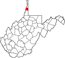 | |
| Towns | ||
| Villages | ||
| Unincorporated communities | ||
| Ghost town | ||
| Footnotes | ‡This populated place also has portions in an adjacent county or counties | |