Worthington, West Virginia
| Worthington, West Virginia | |
|---|---|
| Town | |
|
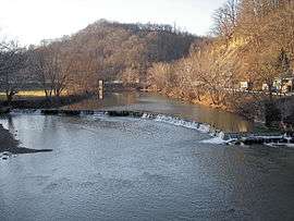
Main Street (Route 19) in Worthington in 2006 | |
 Location in Marion County and the state of West Virginia. | |
| Coordinates: 39°27′6″N 80°15′46″W / 39.45167°N 80.26278°WCoordinates: 39°27′6″N 80°15′46″W / 39.45167°N 80.26278°W | |
| Country | United States |
| State | West Virginia |
| County | Marion |
| Area[1] | |
| • Total | 0.60 sq mi (1.55 km2) |
| • Land | 0.58 sq mi (1.50 km2) |
| • Water | 0.02 sq mi (0.05 km2) |
| Elevation | 922 ft (281 m) |
| Population (2010)[2] | |
| • Total | 158 |
| • Estimate (2012[3]) | 156 |
| • Density | 272.4/sq mi (105.2/km2) |
| Time zone | Eastern (EST) (UTC-5) |
| • Summer (DST) | EDT (UTC-4) |
| ZIP code | 26591 |
| Area code(s) | 304 |
| FIPS code | 54-88708[4] |
| GNIS feature ID | 1556026[5] |

Worthington is a town in Marion County, West Virginia, in the United States. The population was 158 at the 2010 census. Worthington was incorporated in 1893 and named for Colonel George Worthington, an early settler.[6]
Geography
Worthington is located at 39°27′6″N 80°15′46″W / 39.45167°N 80.26278°W (39.451617, -80.262755),[7] along the West Fork River.[8]
According to the United States Census Bureau, the town has a total area of 0.60 square miles (1.55 km2), of which, 0.58 square miles (1.50 km2) is land and 0.02 square miles (0.05 km2) is water.[1]
Demographics
| Historical population | |||
|---|---|---|---|
| Census | Pop. | %± | |
| 1860 | 120 | — | |
| 1870 | 127 | 5.8% | |
| 1880 | 87 | −31.5% | |
| 1910 | 292 | — | |
| 1920 | 381 | 30.5% | |
| 1930 | 405 | 6.3% | |
| 1940 | 507 | 25.2% | |
| 1950 | 544 | 7.3% | |
| 1960 | 361 | −33.6% | |
| 1970 | 288 | −20.2% | |
| 1980 | 329 | 14.2% | |
| 1990 | 233 | −29.2% | |
| 2000 | 170 | −27.0% | |
| 2010 | 158 | −7.1% | |
| Est. 2015 | 160 | [9] | 1.3% |
2010 census
As of the census[2] of 2010, there were 158 people, 67 households, and 47 families residing in the town. The population density was 272.4 inhabitants per square mile (105.2/km2). There were 82 housing units at an average density of 141.4 per square mile (54.6/km2). The racial makeup of the town was 98.1% White and 1.9% from two or more races. Hispanic or Latino of any race were 2.5% of the population.
There were 67 households of which 26.9% had children under the age of 18 living with them, 52.2% were married couples living together, 10.4% had a female householder with no husband present, 7.5% had a male householder with no wife present, and 29.9% were non-families. 26.9% of all households were made up of individuals and 10.5% had someone living alone who was 65 years of age or older. The average household size was 2.36 and the average family size was 2.83.
The median age in the town was 42 years. 19.6% of residents were under the age of 18; 7% were between the ages of 18 and 24; 28.5% were from 25 to 44; 30.4% were from 45 to 64; and 14.6% were 65 years of age or older. The gender makeup of the town was 48.1% male and 51.9% female.
2000 census
As of the census[4] of 2000, there were 170 people, 76 households, and 48 families residing in the town. The population density was 296.2 inhabitants per square mile (115.2/km²). There were 93 housing units at an average density of 162.0 per square mile (63.0/km²). The racial makeup of the town was 99.41% White, and 0.59% from two or more races.
There were 76 households out of which 22.4% had children under the age of 18 living with them, 53.9% were married couples living together, 5.3% had a female householder with no husband present, and 36.8% were non-families. 32.9% of all households were made up of individuals and 25.0% had someone living alone who was 65 years of age or older. The average household size was 2.24 and the average family size was 2.83.
In the town the population was spread out with 19.4% under the age of 18, 7.6% from 18 to 24, 32.9% from 25 to 44, 20.0% from 45 to 64, and 20.0% who were 65 years of age or older. The median age was 41 years. For every 100 females there were 97.7 males. For every 100 females age 18 and over, there were 90.3 males.
The median income for a household in the town was $28,750, and the median income for a family was $35,417. Males had a median income of $24,750 versus $23,750 for females. The per capita income for the town was $14,490. About 10.2% of families and 15.0% of the population were below the poverty line, including 26.3% of those under the age of eighteen and none of those sixty five or over.
Distinguished Residents
Worthington is the town where producer and engineer Steve Allen was born and raised. In 2007 he named his company, Worthington Music Group, after his hometown. He started his career in 1998 by interning at Square One Studio, a Nashville recording studio. He later purchased Square One Studio in Nashville 2001.
References
- 1 2 "US Gazetteer files 2010". United States Census Bureau. Retrieved 2013-01-24.
- 1 2 "American FactFinder". United States Census Bureau. Retrieved 2013-01-24.
- ↑ "Population Estimates". United States Census Bureau. Retrieved 2013-06-26.
- 1 2 "American FactFinder". United States Census Bureau. Retrieved 2008-01-31.
- ↑ "US Board on Geographic Names". United States Geological Survey. 2007-10-25. Retrieved 2008-01-31.
- ↑ West Virginia Blue Book. Published annually by the Clerk's Office of the West Virginia Senate.
- ↑ "US Gazetteer files: 2010, 2000, and 1990". United States Census Bureau. 2011-02-12. Retrieved 2011-04-23.
- ↑ West Virginia Atlas & Gazetteer. Yarmouth, Me.: DeLorme. 1997. p. 25. ISBN 0-89933-246-3.
- ↑ "Annual Estimates of the Resident Population for Incorporated Places: April 1, 2010 to July 1, 2015". Retrieved July 2, 2016.
- ↑ "Census of Population and Housing". Census.gov. Retrieved June 4, 2015.
Municipalities and communities of Marion County, West Virginia, United States | ||
|---|---|---|
| Cities | 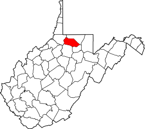 | |
| Towns | ||
| CDPs | ||
| Unincorporated communities |
| |
| Fictional places | ||
| Footnotes | ‡This populated place also has portions in an adjacent county or counties | |