Daviess County, Indiana
| Daviess County, Indiana | |
|---|---|
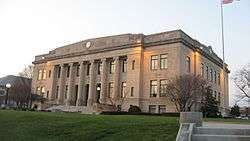 Daviess County courthouse in Washington, Indiana | |
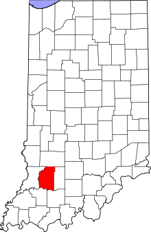 Location in the U.S. state of Indiana | |
 Indiana's location in the U.S. | |
| Founded | February 2, 1818 |
| Named for | Joseph Hamilton Daveiss |
| Seat | Washington |
| Largest town | Washington |
| Area | |
| • Total | 436.87 sq mi (1,131 km2) |
| • Land | 429.49 sq mi (1,112 km2) |
| • Water | 7.39 sq mi (19 km2), 1.69% |
| Population | |
| • (2010) | 31,648 |
| • Density | 73/sq mi (28.37/km²) |
| Congressional district | 8th |
| Time zone | Eastern: UTC-5/-4 |
| Website |
www |
|
Footnotes: Indiana county number 14
| |
Daviess County /ˈdeɪviːz/ is a county located in the U.S. state of Indiana. As of 2010, the population was 31,648.[1] The county seat is Washington.[2]
History
Daviess County was founded in 1818. It was named for Maj. Joseph Hamilton Daveiss,[3] U.S. District Attorney for Kentucky, killed at the Battle of Tippecanoe in 1811. The settlement of the county began along the White River that afforded farmers a convenient means to transport their crops for sale. The county was originally heavily forested in the northeast leading to a thriving timber industry during the first half of the 1800s.[4] Daviess County shares its namesake with another nearby Daviess County of Kentucky. Both Counties are in the Illinois-Indiana-Kentucky Tri-State Area.
Geography
According to the 2010 census, the county has a total area of 436.87 square miles (1,131.5 km2), of which 429.49 square miles (1,112.4 km2) (or 98.31%) is land and 7.39 square miles (19.1 km2) (or 1.69%) is water.[5]
Major highways
Adjacent counties
- Greene County (north)
- Martin County (east)
- Dubois County (southeast)
- Pike County (southwest)
- Knox County (west)
Cities and towns
Incorporated
Unincorporated
Townships
Climate and weather
| Washington, Indiana | ||||||||||||||||||||||||||||||||||||||||||||||||||||||||||||
|---|---|---|---|---|---|---|---|---|---|---|---|---|---|---|---|---|---|---|---|---|---|---|---|---|---|---|---|---|---|---|---|---|---|---|---|---|---|---|---|---|---|---|---|---|---|---|---|---|---|---|---|---|---|---|---|---|---|---|---|---|
| Climate chart (explanation) | ||||||||||||||||||||||||||||||||||||||||||||||||||||||||||||
| ||||||||||||||||||||||||||||||||||||||||||||||||||||||||||||
| ||||||||||||||||||||||||||||||||||||||||||||||||||||||||||||
In recent years, average temperatures in Washington have ranged from a low of 23 °F (−5 °C) in January to a high of 88 °F (31 °C) in July, although a record low of −19 °F (−28 °C) was recorded in December 1989 and a record high of 113 °F (45 °C) was recorded in July 1930. Average monthly precipitation ranged from 2.69 inches (68 mm) in February to 5.52 inches (140 mm) in May.[6]
Government
The county government is a constitutional body, and is granted specific powers by the Constitution of Indiana, and by the Indiana Code. The county council is the legislative branch of the county government and controls all the spending and revenue collection in the county. Representatives are elected from county districts. The council members serve four-year terms. They are responsible for setting salaries, the annual budget, and special spending. The council also has limited authority to impose local taxes, in the form of an income and property tax that is subject to state level approval, excise taxes, and service taxes.[7][8]
The executive body of the county is made of a board of commissioners. The commissioners are elected county-wide, in staggered terms, and each serves a four-year term. One of the commissioners, typically the most senior, serves as president. The commissioners are charged with executing the acts legislated by the council, collecting revenue, and managing the day-to-day functions of the county government.[7][8]
The county maintains a small claims court that can handle some civil cases. The judge on the court is elected to a term of four years and must be a member of the Indiana Bar Association. The judge is assisted by a constable who is also elected to a four-year term. In some cases, court decisions can be appealed to the state level circuit court.[8]
The county has several other elected offices, including sheriff, coroner, auditor, treasurer, recorder, surveyor, and circuit court clerk. Each of these elected officers serves a term of four years and oversees a different part of county government. Members elected to county government positions are required to declare party affiliations and to be residents of the county.[8]
Each of the townships has a trustee who administers rural fire protection and ambulance service, provides poor relief, manages cemetery care, and performs farm assessment, among other duties. The trustee is assisted in these duties by a three-member township board. The trustees and board members are elected to four-year terms.[9]
Daviess County is part of Indiana's 8th congressional district; Indiana Senate districts 39 and 48;[10] and Indiana House of Representatives districts 45, 63 and 64.[11]
Demographics
| Historical population | |||
|---|---|---|---|
| Census | Pop. | %± | |
| 1820 | 3,432 | — | |
| 1830 | 4,543 | 32.4% | |
| 1840 | 6,720 | 47.9% | |
| 1850 | 10,352 | 54.0% | |
| 1860 | 13,323 | 28.7% | |
| 1870 | 16,747 | 25.7% | |
| 1880 | 21,552 | 28.7% | |
| 1890 | 26,227 | 21.7% | |
| 1900 | 29,914 | 14.1% | |
| 1910 | 27,747 | −7.2% | |
| 1920 | 26,856 | −3.2% | |
| 1930 | 25,832 | −3.8% | |
| 1940 | 26,163 | 1.3% | |
| 1950 | 26,762 | 2.3% | |
| 1960 | 26,636 | −0.5% | |
| 1970 | 26,602 | −0.1% | |
| 1980 | 27,836 | 4.6% | |
| 1990 | 27,533 | −1.1% | |
| 2000 | 29,820 | 8.3% | |
| 2010 | 31,648 | 6.1% | |
| Est. 2015 | 32,906 | [12] | 4.0% |
| U.S. Decennial Census[13] 1790-1960[14] 1900-1990[15] 1990-2000[16] 2010-2013[1] | |||
As of the 2010 United States Census, there were 31,648 people, 11,329 households, and 8,116 families residing in the county.[17] The population density was 73.7 inhabitants per square mile (28.5/km2). There were 12,471 housing units at an average density of 29.0 per square mile (11.2/km2).[5] The racial makeup of the county was 95.0% white, 0.5% black or African American, 0.5% Asian, 0.2% American Indian, 2.6% from other races, and 1.1% from two or more races. Those of Hispanic or Latino origin made up 4.2% of the population.[17] In terms of ancestry, 31.4% were German, 13.1% were Irish, 10.8% were American, and 10.6% were English.[18]
Of the 11,329 households, 36.8% had children under the age of 18 living with them, 57.1% were married couples living together, 10.0% had a female householder with no husband present, 28.4% were non-families, and 24.6% of all households were made up of individuals. The average household size was 2.74 and the average family size was 3.29. The median age was 35.4 years.[17]
The median income for a household in the county was $47,697 and the median income for a family was $53,769. Males had a median income of $36,405 versus $29,652 for females. The per capita income for the county was $20,254. About 7.6% of families and 12.3% of the population were below the poverty line, including 16.7% of those under age 18 and 7.6% of those age 65 or over.[19]
See also
External links
The Daviess County Historical Society website is
References
- 1 2 "Daviess County QuickFacts". United States Census Bureau. Retrieved 2011-09-17.
- ↑ "Find a County". National Association of Counties. Retrieved 2011-06-07.
- ↑ Gannett, Henry (1905). The Origin of Certain Place Names in the United States. Govt. Print. Off. p. 101.
- ↑ De Witt Clinton Goodrich & Charles Richard Tuttle (1875). An Illustrated History of the State of Indiana. Indiana: R. S. Peale & co. p. 553.
- 1 2 "Population, Housing Units, Area, and Density: 2010 - County". United States Census Bureau. Retrieved 2015-07-10.
- 1 2 "Monthly Averages for Washington, Indiana". The Weather Channel. Retrieved 2011-01-27.
- 1 2 Indiana Code. "Title 36, Article 2, Section 3". Government of Indiana. Retrieved 2008-09-16.
- 1 2 3 4 Indiana Code. "Title 2, Article 10, Section 2" (PDF). Government of Indiana. Retrieved 2008-09-16.
- ↑ "Government". United Township Association of Indiana. Retrieved 2011-01-06.
- ↑ "Indiana Senate Districts". State of Indiana. Retrieved 2011-01-23.
- ↑ "Indiana House Districts". State of Indiana. Retrieved 2011-01-23.
- ↑ "County Totals Dataset: Population, Population Change and Estimated Components of Population Change: April 1, 2010 to July 1, 2015". Retrieved July 2, 2016.
- ↑ "U.S. Decennial Census". United States Census Bureau. Retrieved July 10, 2014.
- ↑ "Historical Census Browser". University of Virginia Library. Retrieved July 10, 2014.
- ↑ "Population of Counties by Decennial Census: 1900 to 1990". United States Census Bureau. Retrieved July 10, 2014.
- ↑ "Census 2000 PHC-T-4. Ranking Tables for Counties: 1990 and 2000" (PDF). United States Census Bureau. Retrieved July 10, 2014.
- 1 2 3 "DP-1 Profile of General Population and Housing Characteristics: 2010 Demographic Profile Data". United States Census Bureau. Retrieved 2015-07-10.
- ↑ "DP02 SELECTED SOCIAL CHARACTERISTICS IN THE UNITED STATES – 2006-2010 American Community Survey 5-Year Estimates". United States Census Bureau. Retrieved 2015-07-10.
- ↑ "DP03 SELECTED ECONOMIC CHARACTERISTICS – 2006-2010 American Community Survey 5-Year Estimates". United States Census Bureau. Retrieved 2015-07-10.
 |
Greene County | | ||
| Knox County | |
Martin County | ||
| ||||
| | ||||
| Pike County | Dubois County |
The Region of Southwestern Indiana | ||
|---|---|---|
| Central Time Counties | 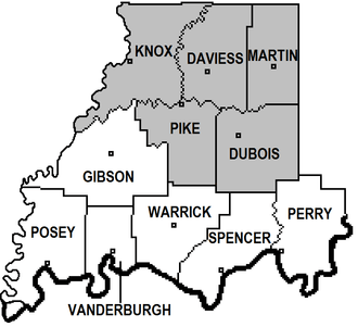 | |
| Eastern Time Counties | ||
| County Seats | ||
| Metropolitan & Micropolitan Areas | ||
| Colleges and Universities |
| |
Municipalities and communities of Daviess County, Indiana, United States | ||
|---|---|---|
| City | ||
| Towns | ||
| Townships | ||
| CDP | ||
| Other unincorporated communities | ||

Coordinates: 38°42′N 87°05′W / 38.70°N 87.08°W