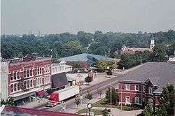
Mount Vernon, Indiana
| City of Mount Vernon, Indiana | |
|---|---|
| City | |
 | |
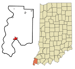 Location in the state of Indiana | |
| Coordinates: 37°56′12″N 87°53′56″W / 37.93667°N 87.89889°WCoordinates: 37°56′12″N 87°53′56″W / 37.93667°N 87.89889°W | |
| Country |
|
| State |
|
| County | Posey |
| Township | Black |
| Settled | c. 1788 |
| Incorporated | 1867 |
| Government | |
| • Mayor | G. William "Bill" Curtis |
| Area[1] | |
| • Total | 7.41 km2 (2.86 sq mi) |
| • Land | 7.28 km2 (2.81 sq mi) |
| • Water | 0.13 km2 (0.05 sq mi) 1.75% |
| Elevation | 122 m (400 ft) |
| Population (2010)[2] | |
| • Total | 6,687 |
| • Estimate (2012[3]) | 6,609 |
| • Density | 918.8/km2 (2,379.7/sq mi) |
| Time zone | CST (UTC-6) |
| • Summer (DST) | CDT (UTC-5) |
| ZIP code | 47620 |
| Area code(s) | 812, 930 |
| FIPS code | 18-51732[4] |
| GNIS feature ID | 0439718[5] |
| Website | http://www.mountvernon.in.gov/ |
Mount Vernon is a city in and the county seat of Posey County, Indiana, United States.[6] Located in the state's far southwestern corner, within 15 miles of either the southernmost or westernmost points it is the westernmost city in the state, but not the southernmost, that being Rockport, about 40 miles to the southeast. The population was 6,687 at the 2010 census. It is located in Black Township and is part of the Evansville, Indiana, metropolitan area, which had a 2010 population of 358,676.
Geography
Mount Vernon is located at 37°56′12″N 87°53′56″W / 37.93667°N 87.89889°W (37.936766, -87.898780).[7]
According to the 2010 census, Mount Vernon has a total area of 2.86 square miles (7.41 km2), of which 2.81 square miles (7.28 km2) (or 98.25%) is land and 0.05 square miles (0.13 km2) (or 1.75%) is water.[1]
Climate
The climate in this area is characterized by hot, humid summers and generally mild to cool winters. According to the Köppen Climate Classification system, Mount Vernon has a humid subtropical climate, abbreviated "Cfa" on climate maps.[8]
History
Mount Vernon is the county seat and largest city in Posey County, named for General Thomas Posey, Governor of the Indiana Territory, who had the distinction of growing up next door to George Washington at the original Mount Vernon, and who was widely rumoured to be Washington's illegitimate son. The rumors were dismissed by Posey's biographer, John Thornton Posey.[9]
Mount Vernon was originally called McFaddin's Bluff, and under the latter name was platted in 1816.[10] The present name is after George Washington's Mount Vernon. A post office called Mount Vernon has been in operation since 1818.[11]
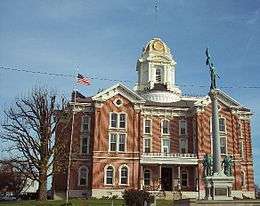
There are a number of historic sites in Mount Vernon, including the Posey County Courthouse Square, Mount Vernon Downtown Historic District, Welborn Historic District and the William Gonnerman House, all of which have been placed on the National Register of Historic Places.[12]
Demographics
| Historical population | |||
|---|---|---|---|
| Census | Pop. | %± | |
| 1850 | 1,120 | — | |
| 1860 | 1,994 | 78.0% | |
| 1870 | 2,880 | 44.4% | |
| 1880 | 3,730 | 29.5% | |
| 1890 | 4,705 | 26.1% | |
| 1900 | 5,132 | 9.1% | |
| 1910 | 5,563 | 8.4% | |
| 1920 | 5,284 | −5.0% | |
| 1930 | 5,035 | −4.7% | |
| 1940 | 5,638 | 12.0% | |
| 1950 | 6,150 | 9.1% | |
| 1960 | 5,970 | −2.9% | |
| 1970 | 6,770 | 13.4% | |
| 1980 | 7,656 | 13.1% | |
| 1990 | 7,217 | −5.7% | |
| 2000 | 7,478 | 3.6% | |
| 2010 | 6,687 | −10.6% | |
| Est. 2015 | 6,550 | [13] | −2.0% |
2010 census
As of the census[2] of 2010, there were 6,687 people, 2,736 households, and 1,819 families residing in the city. The population density was 2,379.7 inhabitants per square mile (918.8/km2). There were 3,077 housing units at an average density of 1,095.0 per square mile (422.8/km2). The racial makeup of the city was 93.4% White, 2.8% African American, 0.3% Native American, 0.4% Asian, 0.8% from other races, and 2.4% from two or more races. Hispanic or Latino of any race were 1.7% of the population.
There were 2,736 households of which 32.0% had children under the age of 18 living with them, 48.4% were married couples living together, 13.6% had a female householder with no husband present, 4.5% had a male householder with no wife present, and 33.5% were non-families. 29.8% of all households were made up of individuals and 13% had someone living alone who was 65 years of age or older. The average household size was 2.40 and the average family size was 2.96.
The median age in the city was 40.2 years. 24.5% of residents were under the age of 18; 8.6% were between the ages of 18 and 24; 23.1% were from 25 to 44; 27.1% were from 45 to 64; and 16.8% were 65 years of age or older. The gender makeup of the city was 47.7% male and 52.3% female.
2000 census
As of the census[4] of 2000, there were 7,478 people, 3,027 households, and 2,058 families residing in the city. The population density was 3,036.0 people per square mile (1,173.7/km²). There were 3,312 housing units at an average density of 1,344.7 per square mile (519.8/km²). The racial makeup of the city was 95.85% White, 2.65% African American, 0.16% Native American, 0.23% Asian, 0.25% from other races, and 0.86% from two or more races. Hispanic or Latino of any race were 0.56% of the population.
There were 3,027 households out of which 33.4% had children under the age of 18 living with them, 52.4% were married couples living together, 12.0% had a female householder with no husband present, and 32.0% were non-families. 28.5% of all households were made up of individuals and 13.5% had someone living alone who was 65 years of age or older. The average household size was 2.43 and the average family size was 2.97.
In the city the population was spread out with 26.1% under the age of 18, 8.0% from 18 to 24, 27.9% from 25 to 44, 23.1% from 45 to 64, and 14.8% who were 65 years of age or older. The median age was 38 years. For every 100 females there were 91.6 males. For every 100 females age 18 and over, there were 88.0 males.
The median income for a household in the city was $36,543, and the median income for a family was $49,432. Males had a median income of $40,045 versus $22,790 for females. The per capita income for the city was $19,264. About 10.5% of families and 12.5% of the population were below the poverty line, including 15.6% of those under age 18 and 13.0% of those age 65 or over.
Government
The city has a mayor and city council form of government. The mayor is elected in citywide vote. The city council consists of five members: four are elected from individual districts and one is elected at-large.
Industry
Mount Vernon is the headquarters of a small oil refinery owned by the CountryMark agricultural cooperative. Originally built in 1940, it processes more than 20,000 barrels of local crude oil per day.
Mount Vernon is also home to a former GE Plastics Plant, now owned by Saudi Arabia Basic Industries Corporation (SABIC). Vectren Energy's A.B. Brown Generating Station is also addressed to Mount Vernon. Mount Vernon is home to two biofuels plants, Abengoa of Indiana and Aventine Renewable Energy. These two facilities helped make Mount Vernon an important energy exporter. The Aventine plant had been developed via partnership with Consolidated Grain and Barge, another company at the port, and was the largest operating ethanol plant east of the Mississippi River. Its nameplate was 110 million gallons of ethanol per year. It was closed in 2012, but it has since resumed operation under Valero Energy ownership.
BWX Technologies (BWXT - formerly Babcock & Wilcox) has a large facility to make large pressure vessels and large metal tubes in Mt. Vernon. This facility made many components for commercial nuclear plants back in the 60's through the 80's and now makes heavy pressure vessels for both commercial and non-commercial power plants.
The Mount Vernon port is also the largest port for coal shipments in the U.S. The John T. Myers Locks and Dam located 13 miles SW of Mount Vernon plays important shipping role for the area's river based industries.
Local media
Mount Vernon is served by two weekly newspapers, The Mount Vernon Democrat and The Posey County News. It is represented by the radio stations WRCY-AM 1590 and WYFX-FM 106.7.
Schools
The city and southern half of Posey County are served by the M.S.D. of Mount Vernon which currently operates 5 schools:
- Mount Vernon Senior High School (9-12)
- Mount Vernon Junior High (6-8)
- Farmersville Elementary School (K-5)
- Marrs Elementary School (K-5)
- West Elementary School (K-5)
- St Matthew's School (K-5) is operated under the auspices of the Diocese of Evansville
Public library
The Alexandrian Public Library serves the residents of Mount Vernon, Indiana, as well as Black, Lynn, Marrs, Point, and Robinson townships (approximately 21,000 residents).
The Main Library, built in 1986, is located at 115 West Fifth Street, and boasts over 100,000 items, a dozen public computers, as well as free Wi-Fi. In addition, a bookmobile operates to serve the area schools and outlying areas of the county.
A monthly book discussion group for adults, numerous storytimes, a Summer Reading Program, targeted programming for youth, young adult and adults is offered free of charge to the public on a regular basis.
The Alexandrian Public Library also has a varied and popular collection of local history resources and family history files in the "Indiana Room" of the Main Library. Microfilmed newspapers, contributed family documents, resources from the Posey County Historical Society and more are available for genealogists and researchers.
Meeting rooms are also available for use by the public at the library. Non-profit groups may use the rooms free of charge, and for-profit groups are charged $5/hour.
The Alexandrian Public Library is open 9am-8pm Monday through Thursday, 9am-5pm on Friday and Saturday, and 1pm-5pm on Sunday.
Transportation
Highways
Rail Service
- Evansville Western Railway, a short line railroad serving area industries both in Indiana and Illinois is headquartered in Mount Vernon.
River Port
- Port of Indiana-Mount Vernon, a major publicly funded riverport, is located just east of Mount Vernon. It began operation in 1976 as Southwind Maritime Center and is one of three public ports operated by the state of Indiana.
Notable people
- H. Joel Deckard (1942-2016) Born in Vandalia, Illinois, Deckard attended public schools in Mount Vernon, Indiana. He served as member of the Indiana House of Representatives from 1966 to 1974 and was later elected to the US House of Representatives serving from 1979 to 1983. He was unsuccessful in his reelection bid in 1982 losing to Frank McCloskey.
- Francis C. Green (1835–1905) was a soldier in the U.S. Army and served with the 8th U.S. Cavalry during the Indian Wars. He was awarded the Medal of Honor in 1869. Born in Mount Vernon and is buried in an unmarked grave in Erin, Tennessee.
- William Harrow (1822–1871) Union general in the Civil War. Born in Winchester, Kentucky, lived in Mount Vernon and is buried in Bellefontaine Cemetery just north of town.
- Alvin P. Hovey (1821–1891) Union general in the Civil War and Governor of Indiana 1889-1891. Played major role in Battle of Champion Hill during the Siege of Vicksburg. Born in Mount Vernon and is buried in Bellefontaine Cemetery.
- Ann Hovey (1911-2007) chorus girl and actress. Held several roles in B-movies in the 1930s. Is a descendant of Gen. Alvin P. Hovey. Born in Mount Vernon and died in Arizona.
- Frederick Charles Leonard (1896–1960) was an American astronomer and faculty member at the University of California, Los Angeles. Born in Mount Vernon and died in Los Angeles.
- Thomas Gamble Pitcher (1824–1895) Union general in the Civil War and was 1845 graduate of the United States Military Academy later serving as Superintendent from 1866 to 1871. Born in Rockport, Indiana, lived in Mount Vernon and is buried in Arlington National Cemetery.
- Richard Sarlls (1839-1915) One of the earliest settlers of Mount Vernon. Born in Ghent, Kentucky he moved to what was known as McFadden's Bluff in 1846. He became a successful grain expert and trader and real estate investor, becoming one of the largest landowners in Posey County, Indiana. He served as a Lieutenant in what was known as the National Home Guard during the Civil War, participating in conflicts across the Ohio River in neighboring Kentucky. He is buried in Bellefontaine Cemetery.
- William Edward Wilson (1870–1948) was a U.S. Representative from Indiana from 1923-1925. Born in Mount Vernon and is buried in Oak Hill Cemetery in Evansville, Indiana.
See also
References
- 1 2 "G001 - Geographic Identifiers - 2010 Census Summary File 1". United States Census Bureau. Retrieved 2015-07-29.
- 1 2 "American FactFinder". United States Census Bureau. Retrieved 2012-12-11.
- ↑ "Population Estimates". United States Census Bureau. Retrieved 2013-06-25.
- 1 2 "American FactFinder". United States Census Bureau. Retrieved 2008-01-31.
- ↑ "US Board on Geographic Names". United States Geological Survey. 2007-10-25. Retrieved 2008-01-31.
- ↑ "Find a County". National Association of Counties. Retrieved 2011-06-07.
- ↑ "US Gazetteer files: 2010, 2000, and 1990". United States Census Bureau. 2011-02-12. Retrieved 2011-04-23.
- ↑ Climate Summary for Mount Vernon, Indiana
- ↑ Gugin, Linda C.; St. Clair, James E, eds. (2006). The Governors of Indiana. Indianapolis, Indiana: Indiana Historical Society Press. p. 33. ISBN 0-87195-196-7.
- ↑ Leffel, John C. (1913). History of Posey County, Indiana. Standard Publishing Company. p. 87.
- ↑ "Posey County". Jim Forte Postal History. Retrieved 1 November 2015.
- ↑ National Park Service (2010-07-09). "National Register Information System". National Register of Historic Places. National Park Service.
- ↑ "Annual Estimates of the Resident Population for Incorporated Places: April 1, 2010 to July 1, 2015". Retrieved July 2, 2016.
- ↑ "Census of Population and Housing". Census.gov. Retrieved June 4, 2015.
External links
- City website
- Metropolitan School District of Mount Vernon
- Alexandrian Public Library
- WRCY Website
- Evansville Western Railway website
- Port of Indiana-Mount Vernon
- Mount Vernon photos and articles
- Battle of Champion Hill
| Central City | 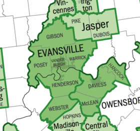 | |
|---|---|---|
| Municipalities with population over 5,000 in 2010 | ||
| Municipalities with population 1,000-5,000 in 2010 | ||
| Indiana Counties | ||
| Kentucky Counties | ||
Municipalities and communities of Posey County, Indiana, United States | ||
|---|---|---|
| City | ||
| Towns | ||
| Townships | ||
| CDP | ||
| Other unincorporated communities | ||
| Footnotes | ‡This populated place also has portions in an adjacent county or counties | |
