Daviess County, Kentucky
| Daviess County, Kentucky | |
|---|---|
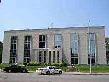 Daviess County courthouse in Owensboro | |
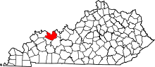 Location in the U.S. state of Kentucky | |
 Kentucky's location in the U.S. | |
| Founded | 1815 |
| Named for | Joseph Hamilton Daveiss |
| Seat | Owensboro |
| Largest city | Owensboro |
| Area | |
| • Total | 477 sq mi (1,235 km2) |
| • Land | 458 sq mi (1,186 km2) |
| • Water | 18 sq mi (47 km2), 3.8% |
| Population (est.) | |
| • (2013) | 98,218 |
| • Density | 198/sq mi (76/km²) |
| Congressional district | 2nd |
| Time zone | Central: UTC-6/-5 |
| Website |
www |
Daviess County (/ˈdeɪvᵻs/ or incorrectly /ˈdeɪviːz/), is a county in the U.S. state of Kentucky. As of the 2010 census, the population was 96,656.[1] Its county seat is Owensboro,[2] which was named for Colonel Abraham Owen, killed at the Battle of Tippecanoe. The county was formed from part of Ohio County on January 14, 1815.
Daviess County is included in the Owensboro, KY Metropolitan Statistical Area.
History
Daviess County was established in 1815. The county is named for Major Joseph Hamilton Daveiss (a recording error in the State Clerk's office accounts for the error in spelling, which was never corrected), the United States Attorney who unsuccessfully prosecuted Aaron Burr.[3] The county's borders were altered in 1829 to form Hancock County, in 1830 to absorb a small area surrounding Whitesville, in 1854 to cede land to McLean County, and in 1860 to annex 44 square miles (110 km2) from Henderson County.
The courthouse burned in January 1865 during the American Civil War, but because the county records had been transferred to a church they were spared destruction.[4]
Geography
According to the U.S. Census Bureau, the county has a total area of 477 square miles (1,240 km2), of which 458 square miles (1,190 km2) is land and 18 square miles (47 km2) (3.8%) is water.[5] The northern half of the county along the Ohio River is relatively flat, with a few rolling hills dotting the landscape. The southern portion is mostly rolling hills mixed with flat valleys. The southern portion was mined for coal in the past, especially in the rolling hills along Panther Creek and other streams.
Adjacent counties
- Warrick County, Indiana (northwest)
- Spencer County, Indiana (northeast)
- Hancock County (east)
- Ohio County (southeast)
- McLean County (southwest)
- Henderson County (west)
Demographics
| Historical population | |||
|---|---|---|---|
| Census | Pop. | %± | |
| 1820 | 3,876 | — | |
| 1830 | 5,209 | 34.4% | |
| 1840 | 8,331 | 59.9% | |
| 1850 | 12,362 | 48.4% | |
| 1860 | 15,549 | 25.8% | |
| 1870 | 20,714 | 33.2% | |
| 1880 | 27,730 | 33.9% | |
| 1890 | 33,120 | 19.4% | |
| 1900 | 38,667 | 16.7% | |
| 1910 | 41,020 | 6.1% | |
| 1920 | 40,733 | −0.7% | |
| 1930 | 43,779 | 7.5% | |
| 1940 | 52,335 | 19.5% | |
| 1950 | 57,241 | 9.4% | |
| 1960 | 70,588 | 23.3% | |
| 1970 | 79,486 | 12.6% | |
| 1980 | 85,949 | 8.1% | |
| 1990 | 87,189 | 1.4% | |
| 2000 | 91,545 | 5.0% | |
| 2010 | 96,656 | 5.6% | |
| Est. 2015 | 99,259 | [6] | 2.7% |
| U.S. Decennial Census[7] 1790-1960[8] 1900-1990[9] 1990-2000[10] 2010-2013[1] | |||
As of the census[11] of 2012, there were 97,847 people, 36,033 households, and 24,826 families residing in the county. The population density was 198 per square mile (76/km2). There were 38,432 housing units at an average density of 83 per square mile (32/km2). The racial makeup of the county was 93.69% White, 4.35% Black or African American, 0.13% Native American, 0.43% Asian, 0.02% Pacific Islander, 0.44% from other races, and 0.94% from two or more races. 0.92% of the population were Hispanic or Latino of any race.
There were 36,033 households out of which 32.90% had children under the age of 18 living with them, 53.60% were married couples living together, 11.80% had a female householder with no husband present, and 31.10% were non-families. 27.10% of all households were made up of individuals and 11.10% had someone living alone who was 65 years of age or older. The average household size was 2.47 and the average family size was 3.00.
In the county the population was spread out with 25.80% under the age of 18, 9.00% from 18 to 24, 28.40% from 25 to 44, 23.00% from 45 to 64, and 13.80% who were 65 years of age or older. The median age was 37 years. For every 100 females there were 92.60 males. For every 100 females age 18 and over, there were 88.30 males.
The median income for a household in the county was $36,813, and the median income for a family was $45,404. Males had a median income of $35,295 versus $21,971 for females. The per capita income for the county was $18,739. About 9.40% of families and 12.30% of the population were below the poverty line, including 15.60% of those under age 18 and 11.40% of those age 65 or over.
Economy
Distilling
Daviess County has long had a reputation as the leading center of the production of distilled spirits, chiefly Kentucky bourbon. Walter McFarland, who moved here from North Carolina, began making whiskey and peach brandy in about 1804 on a 200-acre (0.81 km2) estate just south of Panther Creek, on today's U.S. 431.[12] Cornelius Westerfield also began distilling corn whiskey in the early 1800s on his farm three miles (5 km) southwest of Whitesville, Kentucky, on Deserter Creek. It finally closed in 1872, after more than 60 years of production.[12]
By the 1880s, 18 large distilleries operated in Daviess County at the same time. Today only three remain. One dates back to 1869, the former Glenmore Distillery Company, which was originally the R. Monarch Distillery. Charles Medley Distillers Kentucky is at least the 59th distillery in the county's history.
Trinidad-based Angostura Limited bought the Medley Distillery in 2007 with plans to make its entrance into the world's bourbon market, but the severe global recession slowed plans for starting bourbon production in Daviess County for the first time since 1992.[13]
The following is list of distilleries operating in 1883[14]
- Owensboro Distilling Company, founded 1880
- Sour-Mash Distilling Company, founded 1868
- Hill, Perkins and Company, founded 1880
- Rock Spring Distillery, founded 1881
- Hill and Perkins Distillery, founded 1866
- R. Monarch Distillery, founded 1869, acquired and renamed in 1901 Glenmore Distillery Company
- E.P. Millet and Company, founded 1880
- John Thixton Distillery Company
- John Hanning Distillery Company, founded 1869
- Eagle Distillery Company, founded 1869
- Daviess county Distilling Company, founded April 16, 1874[15]
- M.P. Mattingly's Distyillery, founded 1855
- Daviess County Club Distillery, founded 1880
- J.W.M. Field Distillery, founded February 3, 1873
- J.T. Welch Distilling Company, founded Mar 1, 1881
- Boulware and Wilhoute's Distillery, founded 1880
- C.L. Appelgate and Company distillery, founded 1879 at Yelvington, Kentucky
Coal mining
The southwestern portion of the county around the Panther Creek area was heavily mined through the 1960s till the early 1990s. After 1998 large tracts of mined land were left unclaimed. Then after a lengthy search for contractors by the state government's Division of Abandoned Mine Lands, work commenced on the largest tract, a 42-acre (170,000 m2) tract once part of the now defunct Green Coal Company. The 42 acres (170,000 m2) of unclaimed land were part of Green Coal Company's mine once known as the "Panther Surface Mine". Green Coal Company was a staple mining company in Daviess County and was based nearby in Henderson.
Reclamation work commenced at the site on Nov. 8, 1999, and was completed April 14, 2000. The licensed blaster employed by the contractor blasted the highwall into the pit, resulting in a reduced effort to grade and dress the final slope. Enough topsoil was gained from the area above the highwall to allow a growing medium for re-vegetation purposes. Through innovative field techniques and extraordinary cooperation from the contractor, this site has been returned to a very safe, stable and productive property. All 42 acres (170,000 m2) of this project was reclaimed expending $127,538.82 of the available bond. The land is now safe for the public and is considered prime farm property once again. Green Coal Reclamation Project
Communities
County Seat
West Daviess
- Curdsville
- Delaware
- Moseleyville
- Panther
- Pettit
- Rome
- Saint Joseph
- Sorgho
- Stanley
- Sutherland
- Tuck
- Utica
- West Louisville
East Daviess
- Dermont
- Ensor
- Habit
- Knottsville
- Maceo
- Masonville
- Philpot
- Thruston
- Whitesville
- Yelvington
See also
- List of Sheriffs of Daviess County, Kentucky
- National Register of Historic Places listings in Daviess County, Kentucky
References
- 1 2 "State & County QuickFacts". United States Census Bureau. Retrieved March 6, 2014.
- ↑ "Find a County". National Association of Counties. Retrieved 2011-06-07.
- ↑ Rennick, Robert M. (1987). Kentucky Place Names. University Press of Kentucky. p. 78. Retrieved 2013-04-28.
- ↑ Hogan, Roseann Reinemuth (1992). Kentucky Ancestry: A Guide to Genealogical and Historical Research. Ancestry Publishing. p. 223. Retrieved 26 July 2013.
- ↑ "2010 Census Gazetteer Files". United States Census Bureau. August 22, 2012. Retrieved August 13, 2014.
- ↑ "County Totals Dataset: Population, Population Change and Estimated Components of Population Change: April 1, 2010 to July 1, 2015". Retrieved July 2, 2016.
- ↑ "U.S. Decennial Census". United States Census Bureau. Retrieved August 13, 2014.
- ↑ "Historical Census Browser". University of Virginia Library. Retrieved August 13, 2014.
- ↑ "Population of Counties by Decennial Census: 1900 to 1990". United States Census Bureau. Retrieved August 13, 2014.
- ↑ "Census 2000 PHC-T-4. Ranking Tables for Counties: 1990 and 2000" (PDF). United States Census Bureau. Retrieved August 13, 2014.
- ↑ "American FactFinder". United States Census Bureau. Retrieved 2008-01-31.
- 1 2 "Medley Distillers eager to join Kentucky Bourbon Trail", by Keith Lawrence, Messenger-Inquirer,Monday, September 21, 2009
- ↑ "?".
- ↑ History of Daviess County, Ky., pgs 341–345, Interstate Publishing Company, Chicago, Ill.
- ↑ Daviess County Distilling Company records, 1850–1964, 1850–1940 (bulk dates) full text File Size: 5 K bytes |14 reels of microfilm (50 vols.)Call number: 1F67M-621 University of Kentucky Special Collections and Digital Programs Lexington, Kentucky 40506
External links
Municipalities and communities of Daviess County, Kentucky, United States | ||
|---|---|---|
| Cities | | |
| CDPs | ||
| Other unincorporated communities | ||

Coordinates: 37°44′N 87°05′W / 37.73°N 87.09°W