Linganamakki Dam
| Linganamakki Dam ಲಿಂಗನಮಕ್ಕಿ ಅಣೆಕಟ್ಟು | |
|---|---|
| Official name | Linganamakki Reservoir |
| Location | Linganamakki, Sagara Taluk, Karnataka |
| Coordinates | 14°10′32″N 74°50′47″E / 14.175587°N 74.84627°ECoordinates: 14°10′32″N 74°50′47″E / 14.175587°N 74.84627°E |
| Construction began | 1964 |
| Dam and spillways | |
| Impounds | Sharavathi River |
| Height | 193 ft |
| Length | 2.4 km |
| Reservoir | |
| Creates | Linganamakki Reservoir |
| Total capacity | 151.75 Tmcft |
| Catchment area | 1991.71 km² |
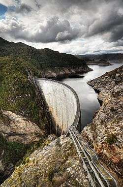
The Linganamakki dam(Kannada: ಲಿಂಗನಮಕ್ಕಿ ಅಣೆಕಟ್ಟು) was constructed by the Karnataka State Government in 1964. Located in the Sagara taluk, the dam has a length of 2.4 km, stretching across the Sharavathi river. It is located about 6 km from Jog Falls.
The dam was designed to impound 4368 million cubic meter of water in an area of around 300 km², submerging 50.62 km² of wetland and 7 km² of dry land, with the remaining being forest land and wasteland .[1]
The dam's height is 1,819 feet (554 m) above sea level.[2] It receives water mainly from rainfall and also from the Chakra and Savahaklu reservoirs, which are linked to Linganamakki through a canal. The water from the Linganamakki dam flows to Talakalale Balancing Reservoir through a trapezoidal canal with a discharge capacity of 175.56 m³/s. The length of this channel is about 4318.40 m with a submersion of 7.77 km². It has a catchment area of about 46.60 km².[3]
Behind the dam is a large reservoir. The discharge from the dam can be quite heavy. When the dam's sluice gates are closed upstream from Jog Falls, it is possible to walk down into the fall's ravine.[4]
The power house has a power generation capacity of 55 MW, from two generating units. They are driven by vertical axis Kaplan turbines. The power house is on the left side of the dam.
See also
References
- ↑ A detailed study on the Sharavathi river is made by Saira Varghese Kidangan. "Quantification of Hydrological responses to landuse changes using Remote Sensing and GIS techniques" (PDF). Online webpage of Indian Institute of Remote Sensing, National Remote Sensing Agency. Dept. of Space, Government of India. Retrieved 2007-05-21.
- ↑ ::prithvibhat.com - Tourist Places -> Jog Falls(Joga)
- ↑ A description of Linganamakki dam is provided by "Proceedings of National Conference on 'Control Of Industrial Pollution and Environmental Degradation', Coimbatore, September 14th and 15th 2001, pp 262-275". Online Webpage of the Centre for Ecological Sciences. Indian Institute of Science, Bangalore. Retrieved 2007-05-21.
- ↑ "Karnataka". Archived from the original on 2006-05-14. Retrieved 2006-09-13.
External links
- Photo of Linganmakki Dam
- Forest fragmentation, especially the construction of the Linganmakki. dam PDF
| Africa |
|  |
|---|---|---|
| Asia | ||
| Australasia |
| |
| Europe |
| |
| North America | ||
| South America |
| |