Papanasam
| Papanasam பாபநாசம் | |
|---|---|
| Panchayat Town | |
|
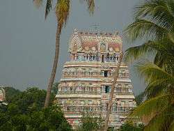
Palaivananathar Sivan Koil | |
 Papanasam Location in Tamil Nadu, India | |
| Coordinates: 10°56′00″N 79°17′00″E / 10.9333°N 79.2833°ECoordinates: 10°56′00″N 79°17′00″E / 10.9333°N 79.2833°E | |
| Country |
|
| State | Tamil Nadu |
| District | Thanjavur |
| Elevation | 22 m (72 ft) |
| Population (2001) | |
| • Total | 16,397 |
| Languages | |
| • Official | Tamil |
| Time zone | IST (UTC+5:30) |
| PIN | 614 205 |
| Telephone code | 914374 |
| Vehicle registration | TN-68 |
Papanasam is a panchayat town in Thanjavur district in the Indian state of Tamil Nadu. It is located 25 kilometres (16 mi) from Thanjavur and 15 kilometres (9.3 mi) from Kumbakonam. The name literally translates to "Destruction of Sins" in the Tamil language.
Geography and climate
Papanasam is located at 10°56′00″N 79°17′00″E / 10.9333°N 79.2833°E and has an average elevation of 22 metres (72 ft). Köppen-Geiger climate classification system classifies its climate as tropical wet and dry.
| Climate data for Papanasam (altitude: 37m) | |||||||||||||
|---|---|---|---|---|---|---|---|---|---|---|---|---|---|
| Month | Jan | Feb | Mar | Apr | May | Jun | Jul | Aug | Sep | Oct | Nov | Dec | Year |
| Average high °C (°F) | 29.3 (84.7) |
31.1 (88) |
33.6 (92.5) |
35.3 (95.5) |
36.7 (98.1) |
36.7 (98.1) |
35.4 (95.7) |
34.8 (94.6) |
34.2 (93.6) |
32.1 (89.8) |
29.7 (85.5) |
28.5 (83.3) |
33.12 (91.62) |
| Daily mean °C (°F) | 25.3 (77.5) |
26.5 (79.7) |
28.5 (83.3) |
30.6 (87.1) |
31.7 (89.1) |
31.6 (88.9) |
30.7 (87.3) |
30 (86) |
29.6 (85.3) |
28.2 (82.8) |
26.4 (79.5) |
25.1 (77.2) |
28.68 (83.64) |
| Average low °C (°F) | 21.3 (70.3) |
21.9 (71.4) |
23.5 (74.3) |
26 (79) |
26.8 (80.2) |
26.6 (79.9) |
26.1 (79) |
25.3 (77.5) |
25.1 (77.2) |
24.3 (75.7) |
23.1 (73.6) |
21.8 (71.2) |
24.32 (75.78) |
| Average precipitation mm (inches) | 35 (1.38) |
12 (0.47) |
13 (0.51) |
36 (1.42) |
55 (2.17) |
39 (1.54) |
60 (2.36) |
134 (5.28) |
99 (3.9) |
198 (7.8) |
208 (8.19) |
137 (5.39) |
1,026 (40.41) |
| Source: Climate-Data.org (altitude: 37m)[1] | |||||||||||||
| Climate data for Papanasam (altitude: 76m) | |||||||||||||
|---|---|---|---|---|---|---|---|---|---|---|---|---|---|
| Month | Jan | Feb | Mar | Apr | May | Jun | Jul | Aug | Sep | Oct | Nov | Dec | Year |
| Average high °C (°F) | 30 (86) |
31.5 (88.7) |
33.2 (91.8) |
33.5 (92.3) |
33.7 (92.7) |
32.2 (90) |
31.3 (88.3) |
31.7 (89.1) |
32.1 (89.8) |
31.2 (88.2) |
29.6 (85.3) |
29.4 (84.9) |
31.62 (88.93) |
| Daily mean °C (°F) | 26.1 (79) |
27.1 (80.8) |
28.6 (83.5) |
29.4 (84.9) |
29.8 (85.6) |
28.7 (83.7) |
28 (82) |
28.2 (82.8) |
28.3 (82.9) |
27.7 (81.9) |
26.4 (79.5) |
25.9 (78.6) |
27.85 (82.1) |
| Average low °C (°F) | 22.2 (72) |
22.7 (72.9) |
24.4 (75.9) |
25.4 (77.7) |
26 (79) |
25.2 (77.4) |
24.8 (76.6) |
24.8 (76.6) |
24.6 (76.3) |
24.2 (75.6) |
23.3 (73.9) |
22.4 (72.3) |
24.17 (75.52) |
| Average precipitation mm (inches) | 37 (1.46) |
30 (1.18) |
49 (1.93) |
88 (3.46) |
82 (3.23) |
101 (3.98) |
79 (3.11) |
47 (1.85) |
63 (2.48) |
202 (7.95) |
204 (8.03) |
93 (3.66) |
1,075 (42.32) |
| Source: Climate-Data.org (altitude: 76m)[2] | |||||||||||||
Demographics
As of 2001 India census,[3] Papanasam had a population of 16,397. Males constitute 50% of the population and females 50%. Papanasam has an average literacy rate of 76%, higher than the national average of 59.5%: male literacy is 82%, and female literacy is 70%. In Papanasam, 11% of the population is under 6 years of age.
Places of interest

There are three major temples, Pallaivanatha Swamy temple constructed by the Cholas, Srinivasa Perumal Temple and 108 Sivalayam temple. A granary measuring 86 feet (26 m) in width and 36 feet (11 m) in height constructed by Nayaks between 1600–1634 has been declared by the State Archaeological Department as a protected monument.
Transport
Papanasam railway station is situated between Thanjavur and Kumbakonam.
Politics
Papanasam assembly constituency is part of Mayiladuturai Lok Sabha constituency.[4]
Notable people
- Papanasam Sivan, classical singer
- Sri Sri Ravishankar, spiritual leader
References
- ↑ "Climate: Papanasam (altitude: 37m) - Climate graph, Temperature graph, Climate table". Climate-Data.org. Retrieved 2013-12-29.
- ↑ "Climate: Papanasam (altitude: 76m) - Climate graph, Temperature graph, Climate table". Climate-Data.org. Retrieved 29 December 2013.
- ↑ "Census of India 2001: Data from the 2001 Census, including cities, villages and towns (Provisional)". Census Commission of India. Archived from the original on 2004-06-16. Retrieved 1 November 2008.
- ↑ "List of Parliamentary and Assembly Constituencies" (PDF). Election Commission of India. Retrieved 12 October 2008.
| State symbols |
|
|---|---|
| Governance |
|
| Topics | |
| Districts |
|
| Major cities | |
| District headquarters |  | |
|---|---|---|
| Country | ||
| State | ||
| Region | ||
| Divisions | ||
| Taluks | ||
| Revenue blocks | ||
| Municipal Corporations | ||
| Municipalities | ||
| Rivers | ||
| History | ||
| Places of interest |
| |
| Religious and monastic institutions | ||
| Universities | ||
| ||