Asten, Netherlands
| Asten | ||
|---|---|---|
| Municipality | ||
|
Asten | ||
| ||
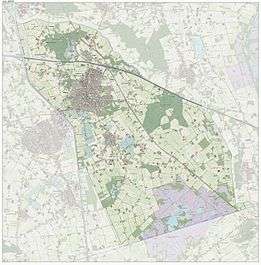
.svg.png) Location in North Brabant | ||
| Coordinates: 51°24′N 5°45′E / 51.400°N 5.750°ECoordinates: 51°24′N 5°45′E / 51.400°N 5.750°E | ||
| Country | Netherlands | |
| Province | North Brabant | |
| Government[1] | ||
| • Body | Municipal council | |
| • Mayor | Hubert Vos (CDA) | |
| Area[2] | ||
| • Total | 71.34 km2 (27.54 sq mi) | |
| • Land | 70.21 km2 (27.11 sq mi) | |
| • Water | 1.13 km2 (0.44 sq mi) | |
| Elevation[3] | 27 m (89 ft) | |
| Population (May 2014)[4] | ||
| • Total | 16,565 | |
| • Density | 236/km2 (610/sq mi) | |
| Demonym(s) | Astenaar | |
| Time zone | CET (UTC+1) | |
| • Summer (DST) | CEST (UTC+2) | |
| Postcode | 5720–5725 | |
| Area code | 0493 | |
| Website |
www | |
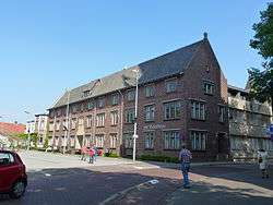

Asten (![]() pronunciation ) is a municipality and a town in the southern Netherlands.
pronunciation ) is a municipality and a town in the southern Netherlands.
It is home to the Royal Eijsbouts bell foundry and also a carillon museum.
The spoken language is Peellands, an East Brabantian dialect.[5]
Population centres
- Asten
- Heusden
- Ommel
History
Asten has a rich history going back to the Roman period. In the swamp of the village's national park 'De Peel' an ancient Roman centurion helmet was found. Silhouets of Hunter-Gatherer and Agricultural societies were also found in the area. The village has a castle dating back to the 12th century, at the south of the current village. It has also given its name to the village: "Aa-Stein", or "stone building on the river Aa". A second stone-built fortified building was suspected at the north, at the site of the current Slotweg ("castle road") to be precise. Some stone fragments have been excavated, although no conclusive evidence of a fortified building has been produced here. The village was pillaged and burnt twice in the 17th century, by Austrian and Swedish army troops.
Notable residents
- Frits de Bruin, Second World War resistance hero, butchered by the Germans in 1944
- Bart Claessen, Trance music DJ
- Nance, TV host and former Twenty 4 Seven vocalist (born)
- Eric Dikeb, DJ
- Vivian Jansen, 5th in the Miss Universe competition in 1992
- Martin Koolhoven, Film director
- Piet Raijmakers, equestrian
References
- ↑ "College van burgemeester en wethouders" [Board of mayor and aldermen] (in Dutch). Gemeente Asten. Archived from the original on 26 April 2014. Retrieved 25 April 2014.
- ↑ "Kerncijfers wijken en buurten" [Key figures for neighbourhoods]. CBS Statline (in Dutch). CBS. 2 July 2013. Retrieved 12 March 2014.
- ↑ "Postcodetool for 5721GJ". Actueel Hoogtebestand Nederland (in Dutch). Het Waterschapshuis. Retrieved 25 April 2014.
- ↑ "Bevolkingsontwikkeling; regio per maand" [Population growth; regions per month]. CBS Statline (in Dutch). CBS. 26 June 2014. Retrieved 24 July 2014.
- ↑ Jos & Cor Swanenberg: Taal in stad en land: Oost-Brabants, ISBN 9012090105
External links
 Media related to Asten, Netherlands at Wikimedia Commons
- Official website
- Website National Carillon-museum
 |
Helmond | | ||
| Someren | |
Deurne | ||
| ||||
| | ||||
| Nederweert (LI) | Peel en Maas (LI) |
