Conakry
| Conakry Kɔnakiri | |
|---|---|
|
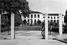
Aerial view of Conakry, Guinea | |
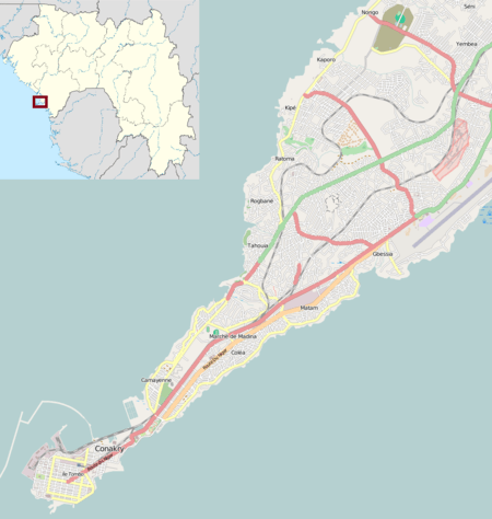
 Conakry Map of Guinea showing the location of Conakry. | |
| Coordinates: 9°31′N 13°42′W / 9.517°N 13.700°W | |
| Country |
|
| Region | Conakry Region |
| Area | |
| • Total | 450 km2 (170 sq mi) |
| Population (2014 census) | |
| • Total | 1,660,973 |
| • Density | 3,700/km2 (9,600/sq mi) |
| Time zone | UTC (UTC±0) |
| • Summer (DST) | not observed (UTC) |
Conakry (Sosso: Kɔnakiri) is the capital and largest city of Guinea. Conakry is a port city on the Atlantic Ocean and serves as the economic, financial and cultural centre of Guinea. Its population as of the 2014 Guinea census was 1,660,973 [1] Originally situated on Tombo Island, one of the Îles de Los, it has since spread up the neighboring Kaloum Peninsula.
The current population of Conakry is difficult to ascertain, although the U.S. Bureau of African Affairs has estimated it at 2 million.[2] Conakry is thought to contain almost a quarter of the population of Guinea.
Etymology
According to a legend, the name of the city comes from the fusion of the name "Cona", a wine producer of the Baga people, and the word "nakiri", which means in Sosso the other bank or side.[3]
History


Conakry was originally settled on the small Tombo Island and later spread to the neighboring Kaloum Peninsula, a 36-kilometer (22 mi) long stretch of land 0.2 to 6 kilometers (660 to 19,690 ft) wide. The city was essentially founded after Britain ceded the island to France in 1887. In 1885 the two island villages of Conakry and Boubinet had fewer than 500 inhabitants. Conakry became the capital of French Guinea in 1904 and prospered as an export port, particularly after a railway (now closed) to Kankan opened up the interior of the country for the large-scale export of groundnut.
In the decades after independence, the population of Conakry boomed, from 50,000 inhabitants in 1958 to 600,000 in 1980, to over two million today.[4] Its small land area and relative isolation from the mainland, while an advantage to its colonial founders, has created an infrastructural burden since independence.[5]
In 1970 conflict between Portuguese forces and the PAIGC in neighbouring Portuguese Guinea (now Guinea-Bissau) spilled into the Republic of Guinea when a group of 350 Portuguese troops and Guinean dissidents landed near Conakry, attacked the city and freed 26 Portuguese prisoners of war held by the PAIGC before retreating, having failed to overthrow the government or kill the PAIGC leadership.[6]
Camp Boiro, a feared concentration camp during the rule of Sekou Toure, was located in Conakry.[7]
According to human rights groups, 157 people died during the 2009 Guinea protest when the military junta opened fire against tens of thousands of protesters in the city on 28 September 2009.[8]
Government and administration

Conakry is a special city with a single region and prefecture government. The local government of the city was decentralized in 1991 between five municipal communes headed by a mayor.[9] From the tip in the southwest, these are:
- Kaloum – the city centre
- Dixinn – including the University of Conakry and many embassies
- Ratoma – known for its nightlife
- Matam
- Matoto – home to Conakry International Airport.
The five urban communes make up the Conakry Region, one of the eight Regions of Guinea, which is headed by a governor. At the second-tier prefecture level, the city is designated as the Conakry Special Zone, though the prefecture and regional government are one and the same. At an estimated two million inhabitants, it is far and away the largest city in Guinea, making up almost a quarter of the nation's population and making it more than four times bigger than its nearest rival, Kankan.
Economy
Conakry is Guinea's largest city and its administrative, communications, and economic centre. The city's economy revolves largely around the port, which has modern facilities for handling and storing cargo, through which alumina and bananas are shipped. Manufactures include food products and housing materials.
Infrastructure crisis
Periodic power and water cuts have been a daily burden for Conakry's residents since early 2002. Government and power company officials blame the drought of February 2001 for a failure of the hydro-electric supply to the capital, and a failure of aging machinery for the continuation of the crisis. Critics of the government cite mis-management, corruption and the withdrawal of the power agency's French partner at the beginning of 2002. As of 2007, much of the city has no traffic lighting in the overnight hours.[10]
Popular anger at shortages in Conakry was entwined with anti-government protests, strikes, and violence against the rule of President Lansana Conté and the successive prime ministers Cellou Dalein Diallo and Eugène Camara appointed to fill the post after the resignation of Prime Minister François Lonseny Fall in April 2004. Violence reached a peak in January–February 2007 in a general strike, which saw over one hundred deaths when the Army confronted protesters.[11]
Transportation
Conakry is serviced by Conakry International Airport which has flights to several cities in West Africa and Europe.
Climate
According to Köppen climate classification, Conakry features a tropical monsoon climate (Köppen climate classification: Am). Conakry features a wet season and a dry season. Like a good portion of West Africa, Conakry's dry season is influenced by the harmattan wind between December and April. As a result, relatively little precipitation falls in the city during these months.
Unlike much of West Africa, Conakry's wet season sees an extraordinary amount of precipitation, averaging more than 1,100 mm both in July and August. As a result, Conakry averages nearly 3,800 mm (149 in.) of precipitation per year.
| Climate data for Conakry (1961–1990) | |||||||||||||
|---|---|---|---|---|---|---|---|---|---|---|---|---|---|
| Month | Jan | Feb | Mar | Apr | May | Jun | Jul | Aug | Sep | Oct | Nov | Dec | Year |
| Average high °C (°F) | 32.2 (90) |
33.1 (91.6) |
33.4 (92.1) |
33.6 (92.5) |
33.2 (91.8) |
31.8 (89.2) |
30.2 (86.4) |
29.9 (85.8) |
30.6 (87.1) |
30.9 (87.6) |
32.0 (89.6) |
32.2 (90) |
31.9 (89.4) |
| Daily mean °C (°F) | 26.1 (79) |
26.5 (79.7) |
27.0 (80.6) |
27.4 (81.3) |
27.5 (81.5) |
26.5 (79.7) |
25.5 (77.9) |
25.2 (77.4) |
25.6 (78.1) |
26.3 (79.3) |
27.0 (80.6) |
26.6 (79.9) |
26.4 (79.5) |
| Average low °C (°F) | 19.0 (66.2) |
20.2 (68.4) |
21.2 (70.2) |
22.0 (71.6) |
20.7 (69.3) |
20.2 (68.4) |
20.4 (68.7) |
20.8 (69.4) |
20.7 (69.3) |
20.4 (68.7) |
21.0 (69.8) |
20.1 (68.2) |
20.6 (69.1) |
| Average rainfall mm (inches) | 1 (0.04) |
1 (0.04) |
3 (0.12) |
22 (0.87) |
137 (5.39) |
396 (15.59) |
1,130 (44.49) |
1,104 (43.46) |
617 (24.29) |
295 (11.61) |
70 (2.76) |
8 (0.31) |
3,784 (148.98) |
| Average rainy days (≥ 1.0 mm) | 0 | 0 | 0 | 2 | 9 | 18 | 27 | 27 | 22 | 17 | 6 | 1 | 129 |
| Average relative humidity (%) | 71 | 70 | 68 | 70 | 74 | 81 | 85 | 87 | 85 | 81 | 79 | 73 | 77 |
| Mean monthly sunshine hours | 223 | 224 | 251 | 222 | 208 | 153 | 109 | 87 | 135 | 189 | 207 | 214 | 2,222 |
| Source: NOAA[12] | |||||||||||||
Notable landmarks
Hospitals
- Donka Hospital
- Ignace Deen Hospital[13]
- Clinique Ambroise Paré[14]
- Clinique Pasteur
Hotels
Markets
Palaces and museums
- Casa de Belle Vue[20]
- Center Culturel Franco Guineen[21]
- Sandervalia National Museum[22]
- Palais de Nations[23]
- Presidential Palace[24]
- Palais du Peuple[25]
Parks and gardens
- Jardin 2 Octubre[26]
- Conakry Botanical Garden[27]
Places of worship
- Cathedrale Sainte-Marie[28]
- Paroisse Saint Michel
- Conakry Grand Mosque[28]
Universities and education
- College Gbessia Centre
- College-Lycee Sainte-Marie
- Gamal Abdel Nasser University (Institut Polytechnique de Conakry)[29][30]
- Institut Geographique National (Guinea)[31]
- National Library of Guinea and National Archives of Guinea[22]*Université Kofi Annan[32]
Other
- 8 November Bridge
- Camp Boiro[33]
- Conakry International Airport
- Monument du 22 Novembre 1970[34]
- Stade du 28 Septembre
See also
Notes
- ↑ "GeoHive - Guinea population statistics". geohive.com. Archived from the original on 2015-11-24. Retrieved 2016-06-05.
- ↑ "Background Note: Guinea". Bureau of African Affairs, U.S. Department of State, January 2007. Retrieved 24 February 2007; World Gazetteer. Retrieved 16 June 2008
- ↑ Histoire de Conakry – (French)
- ↑ Patrick Manning. Francophone Sub-Saharan Africa, 1880–1995, Cambridge (1998)
- ↑ For the urban infrastructure and its history, see M. Dian DIALLO. Street Addressing And Basic Services In Conakry, Guinea. Presented at the Urban Forum/ World Bank – Washington, D.C. – 2–4 April 2002.
- ↑ "Cloudy Days in Conakry". Time. 7 December 1970.
- ↑ Gomez, Alsény René (2010). La Guinée peut-elle être changée?. Editions L'Harmattan. ISBN 2-296-11963-8.
- ↑ "Guinea massacre toll put at 157". BBC News. 29 September 2009.
- ↑ "Guineeconakry.info – Conakry (la capitale)". Retrieved 14 October 2014.
- ↑ Conakry's dark streets turning orange. James Copnall, BBC News, Guinea . 23 November 2006.
- ↑ For the relations between the 2007 crisis and infrastructure in Conakry, see:
- Q&A: Guinea emergency, BBC World Service. 13 February 2007.
- Youths Chase Staff From State Electricity Offices, Protesting Power Cuts, 25 October 2007 (UN Integrated Regional Information Networks/All Africa Global Media via COMTEX).
- IRIN In-Depth, Guinea: Living on the edge. UN Office for the Coordination of Humanitarian Affairs, January 2005.
- GUINEA: Power cuts stop for football, 26 January 2006 (IRIN)
- Guinea protests over power-cuts, Alhassan Sillah: BBC, Conakry, 31 January 2003
- Conflict history: Guinea. International Crisis Group, updated 11 May 2007.
- ↑ "Conakry Climate Normals 1961–1990". National Oceanic and Atmospheric Administration. Retrieved July 6, 2015.
- ↑ Rev Fr Gynecol Obstet, Diallo MS, Diallo TS, Diallo FB, Diallo Y, Camara AY, Onivogui G, Keita N, Diawo SA. (1995) Mar;90(3):138-41., Anemia and pregnancy. Epidemiologic, clinical and prognostic study at the university clinic of the Ignace Deen Hospital, Conakry (Guinee), Clinique universitaire de Gynécologie-Obstétrique, Hôpital Ignace Deen, Conakry Guinée.
- ↑ Young, Isabelle; Gherardin, Tony (15 July 2008). Africa. Lonely Planet. p. 411. ISBN 978-1-74059-143-0. Retrieved 16 March 2011.
- ↑ Boone, Sylvia Ardyn (May 1974). West African travels: a guide to people and places. Random House. p. 139. ISBN 978-0-394-46154-0. Retrieved 15 March 2011.
- ↑ Diawara, Manthia (2000). In search of Africa. Harvard University Press. p. 134. ISBN 978-0-674-00408-5. Retrieved 15 March 2011.
- ↑ Auzias, Dominique; Labourdette, Jean-Paul; Gazel, Alexandra (7 March 2007). République de Guinée, Guinée-Bissau. Petit Futé. p. 65. ISBN 978-2-7469-1603-6. Retrieved 15 March 2011.
- ↑ Jeune Afrique L'intelligent. Groupe Jeune Afrique. January 2004. Retrieved 15 March 2011.
- 1 2 Hudgens, Jim; Trillo, Richard (30 December 2003). The rough guide to West Africa. Rough Guides. p. 558. ISBN 978-1-84353-118-0. Retrieved 16 March 2011.
- ↑ "Economie". Infoguinee.com. Retrieved 16 March 2011.
- ↑ Kalani; Ryan Camara (8 January 2007). World Rhythms! Arts Program Presents West African Drum & Dance: A Yankadi-Macrou Celebration (Teacher's Guide), Book, DVD & CD. Alfred Music Publishing. p. 114. ISBN 978-0-7390-3869-7. Retrieved 16 March 2011.
- 1 2 Worldmark Encyclopedia of the Nations: Africa. Gale Research. 1995. p. 189. ISBN 978-0-8103-9880-1. Retrieved 16 March 2011.
- ↑ Schwarz-Bart, Simone; Schwarz-Bart, André (2003). In Praise of Black Women: Modern African women. Univ of Wisconsin Press. p. 121. ISBN 978-0-299-17270-1. Retrieved 16 March 2011.
- ↑ Davidson, Basil (1989). The fortunate isles: a study in African transformation. Africa World Press. p. 104. ISBN 978-0-86543-122-5. Retrieved 16 March 2011.
- ↑ GUINEA Dying for Change Brutality and Repression by Guinean Security Forces in Response to a Nationwide Strike. Human Rights Watch. p. 17. GGKEY:1UZAQCJ7E3A. Retrieved 16 March 2011.
- ↑ Europa Publications (9 December 2003). Africa South of the Sahara 2004. Psychology Press. p. 520. ISBN 978-1-85743-183-4. Retrieved 16 March 2011.
- ↑ Encyclopaedia Britannica; inc (1993). The New Encyclopædia Britannica: Micropædia. Encyclopædia Britannica. p. 512. ISBN 978-0-85229-571-7. Retrieved 16 March 2011.
- 1 2 Devey, Muriel (2009). La Guinée. KARTHALA Editions. p. 230. ISBN 978-2-8111-0037-7. Retrieved 16 March 2011.
- ↑ O'Toole, Thomas; Baker, Janice E. (2005). Historical dictionary of Guinea. Scarecrow Press. p. 112. ISBN 978-0-8108-4634-0. Retrieved 16 March 2011.
- ↑ K G Saur Books (31 December 2006). International directory of arts. K.G. Saur. ISBN 978-3-598-23113-1. Retrieved 16 March 2011.
- ↑ Böhme, Rolf (December 1991). Inventory of World Topographic Mapping: South America, Central America, and Africa. Published on behalf of the International Cartographic Association by Elsevier Applied Science Publishers. p. 344. ISBN 978-1-85166-661-4. Retrieved 16 March 2011.
- ↑ "Etudes en Guinee" (PDF) (in French). Projet EtudiantGuinée. Archived from the original (PDF) on 26 July 2011. Retrieved 16 March 2011.
- ↑ Bâ, Ardo Ousmane (1986). Camp Boiro. L'Harmattan. ISBN 978-2-85802-649-4. Retrieved 16 March 2011.
- ↑ Bartke, Wolfgang (1975). China's economic aid. Holmes & Meier Publishers. p. 119. ISBN 978-0-8419-0179-7. Retrieved 16 March 2011.
References
- Thomas O'Toole, Janice E. Baker. Historical Dictionary of Guinea. Scarecrow Press (2005). ISBN 0-8108-4634-9
- Odile Goerg. "Chieftainships between Past and Present: From City to Suburb and Back in Colonial Conakry, 1890s–1950s". Africa Today, Summer 2006, Vol. 52, No. 4, Pages 2–27
- Conakry the Capital: history of the city at site of expat artist.
- HISTOIRE DE CONAKRY, 1463 to present, by Luc MOGENET, reprinted at guineeconakry.info (no date)
- Kids in Guinea Study Under Airport Lamps, RUKMINI CALLIMACHI The Associated Press, Thursday, 19 July 2007.
- Archdiocese of Conakry: history and structure (at catholic-hierarchy.org)
- Guinea's Telecommunication Infrastructure, United Nations Economic Commission for Africa (UNECA), 1999 figures.
External links
| Wikivoyage has a travel guide for Conakry. |
- guineeconakry.info/: Conakry – based news portal
- Le Jour Guinée (French)
- Office National du Tourisme, République du Guinée.
![]() Conakry travel guide from Wikivoyage
Conakry travel guide from Wikivoyage
- l’Université Kofi Annan de Guinée (UNIKAG)
- Satellite image of Conakry and the Kaloum Peninsula, from the European Space Agency's Envisat: image description at http://www.esa.int/esaEO/SEMAV21XDYD_index_1.html.
Coordinates: 09°30′33″N 13°42′44″W / 9.50917°N 13.71222°W

