Grant County, Kentucky
| Grant County, Kentucky | |
|---|---|
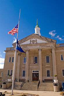 The Grant County courthouse in Williamstown | |
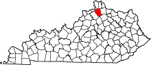 Location in the U.S. state of Kentucky | |
 Kentucky's location in the U.S. | |
| Founded | 1820 |
| Seat | Williamstown |
| Largest city | Williamstown |
| Area | |
| • Total | 261 sq mi (676 km2) |
| • Land | 258 sq mi (668 km2) |
| • Water | 2.8 sq mi (7 km2), 1.1% |
| Population | |
| • (2010) | 24,682 |
| • Density | 96/sq mi (37/km²) |
| Congressional district | 4th |
| Time zone | Eastern: UTC-5/-4 |
| Website |
grantcounty |
Grant County is a county located in the U.S. state of Kentucky. As of the 2010 census, the population was 24,662.[1] Its county seat is Williamstown.[2] The county was formed in 1820 and named for Colonel John Grant,[3] who led a party of settlers in 1779 to establish Grant's Station, in today's Bourbon County, Kentucky.
Grant County is included in the Cincinnati-Middletown, OH-KY-IN Metropolitan Statistical Area.
Grant County is a limited dry county, meaning that sale of alcohol in the county is prohibited, except in Crittenden, Corinth, Dry Ridge and Williamstown, where it is legal by the drink in restaurants seating at least 100 diners and deriving at least 70% of total sales from food. In the 19th century, Grant County contained multiple saloons.[4]
The Grant County News, established in 1906 and published in Williamstown, is preserved on microfilm by the University of Kentucky Libraries. The microfilm holdings are listed in a master negative database on the UK Libraries Preservation and Digital Programs website.[5]
History
Grant County was established in 1820 from land taken from Pendleton County. The present courthouse, built in 1939, replaced two earlier structures.[6]
Geography
According to the U.S. Census Bureau, the county has a total area of 261 square miles (680 km2), of which 258 square miles (670 km2) is land and 2.8 square miles (7.3 km2) (1.1%) is water.[7]
Adjacent counties
- Boone County (north)
- Kenton County (northeast)
- Pendleton County (east)
- Harrison County (southeast)
- Scott County (south)
- Owen County (west)
- Gallatin County (northwest)
Demographics
| Historical population | |||
|---|---|---|---|
| Census | Pop. | %± | |
| 1830 | 2,986 | — | |
| 1840 | 4,192 | 40.4% | |
| 1850 | 6,531 | 55.8% | |
| 1860 | 8,356 | 27.9% | |
| 1870 | 9,529 | 14.0% | |
| 1880 | 13,083 | 37.3% | |
| 1890 | 12,671 | −3.1% | |
| 1900 | 13,239 | 4.5% | |
| 1910 | 10,581 | −20.1% | |
| 1920 | 10,435 | −1.4% | |
| 1930 | 9,876 | −5.4% | |
| 1940 | 9,876 | 0.0% | |
| 1950 | 9,809 | −0.7% | |
| 1960 | 9,489 | −3.3% | |
| 1970 | 9,999 | 5.4% | |
| 1980 | 13,308 | 33.1% | |
| 1990 | 15,737 | 18.3% | |
| 2000 | 22,384 | 42.2% | |
| 2010 | 24,682 | 10.3% | |
| Est. 2015 | 24,757 | [8] | 0.3% |
| U.S. Decennial Census[9] 1790-1960[10] 1900-1990[11] 1990-2000[12] 2010-2013[1] | |||
As of the census[13] of 2000, there were 22,384 people, 8,175 households, and 6,221 families residing in the county. The population density was 86 per square mile (33/km2). There were 9,306 housing units at an average density of 36 per square mile (14/km2). The racial makeup of the county was 98.31% White, 0.25% Black or African American, 0.23% Native American, 0.29% Asian, 0.05% Pacific Islander, 0.32% from other races, and 0.54% from two or more races. 1.04% of the population were Hispanic or Latino of any race.
There were 8,175 households out of which 39.60% had children under the age of 18 living with them, 60.10% were married couples living together, 11.10% had a female householder with no husband present, and 23.90% were non-families. 19.80% of all households were made up of individuals and 8.20% had someone living alone who was 65 years of age or older. The average household size was 2.72 and the average family size was 3.10.
In the county the population was spread out with 28.70% under the age of 18, 9.40% from 18 to 24, 31.50% from 25 to 44, 20.90% from 45 to 64, and 9.50% who were 65 years of age or older. The median age was 33 years. For every 100 females there were 97.10 males. For every 100 females age 18 and over, there were 94.80 males.
The median income for a household in the county was $38,438, and the median income for a family was $42,605. Males had a median income of $31,987 versus $23,669 for females. The per capita income for the county was $16,776. About 9.00% of families and 11.10% of the population were below the poverty line, including 15.10% of those under age 18 and 13.40% of those age 65 or over.
Education

Grant County has six schools: Crittenden Mt Zion (CMZ), Dry Ridge Elementary (DRE), Sherman Elementary (SES), Mason Corinth Elementary (MCE), Grant County Middle School (GCMS), Grant County High School (GCHS) and Williamstown Independent Schools (WES)- (WMS) - (WHS).
Grant County's only library is located in Williamstown, Kentucky.
Infrastructure
Transportation
Public transportation is provided by Senior Services of Northern Kentucky with demand-response service.[14]
Communities
- Corinth
- Crittenden
- Dry Ridge
- Williamstown (county seat)
See also
References
- 1 2 "State & County QuickFacts". United States Census Bureau. Retrieved March 6, 2014.
- ↑ "Find a County". National Association of Counties. Retrieved 2011-06-07.
- ↑ Bergstrom, Bill (December 11, 1984). "Origins of place names are traced". Kentucky New Era. pp. 2B. Retrieved 29 April 2015.
- ↑ Collins, Lewis (1877). History of Kentucky. p. 290.
- ↑
- ↑ Hogan, Roseann Reinemuth (1992). Kentucky Ancestry: A Guide to Genealogical and Historical Research. Ancestry Publishing. p. 238. Retrieved 26 July 2013.
- ↑ "2010 Census Gazetteer Files". United States Census Bureau. August 22, 2012. Retrieved August 14, 2014.
- ↑ "County Totals Dataset: Population, Population Change and Estimated Components of Population Change: April 1, 2010 to July 1, 2015". Retrieved July 2, 2016.
- ↑ "U.S. Decennial Census". United States Census Bureau. Retrieved August 14, 2014.
- ↑ "Historical Census Browser". University of Virginia Library. Retrieved August 14, 2014.
- ↑ "Population of Counties by Decennial Census: 1900 to 1990". United States Census Bureau. Retrieved August 14, 2014.
- ↑ "Census 2000 PHC-T-4. Ranking Tables for Counties: 1990 and 2000" (PDF). United States Census Bureau. Retrieved August 14, 2014.
- ↑ "American FactFinder". United States Census Bureau. Retrieved 2008-01-31.
- ↑ "SSNK Transportation Services". Senior Services of Northern Kentucky. Retrieved 2015-05-19.
External links
Municipalities and communities of Grant County, Kentucky, United States | ||
|---|---|---|
| Cities | | |
| Unincorporated communities | ||
| Footnotes | ‡This populated place also has portions in an adjacent county or counties | |

Coordinates: 38°38′N 84°37′W / 38.64°N 84.61°W