Johnson County, Kentucky
| Johnson County, Kentucky | |
|---|---|
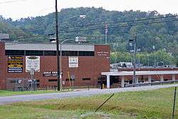
.jpg) Johnson County Judicial Center in Paintsville | |
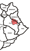
 Location in the U.S. state of Kentucky | |
 Kentucky's location in the U.S. | |
| Founded | February 24, 1843 |
| Named for | Richard Mentor Johnson |
| Seat | Paintsville |
| Largest city | Paintsville |
| Area | |
| • Total | 264 sq mi (684 km2) |
| • Land | 262 sq mi (679 km2) |
| • Water | 2.2 sq mi (6 km2), 0.8% |
| Population | |
| • (2010) | 23,356 |
| • Density | 89/sq mi (34/km²) |
| Congressional district | 5th |
| Time zone | Eastern: UTC-5/-4 |
| Website |
www |
Johnson County is a county located in the U.S. state of Kentucky. As of the 2010 census, the population was 23,356.[1] Its county seat is Paintsville.[2] The county was formed in 1843 and named for Richard Mentor Johnson, War of 1812 general, United States Representative, Senator, and Vice President of the United States.[3] Johnson County is classified as a moist county, which is a county in which alcohol sales are not allowed (a dry county), but containing a "wet" city, in this case Paintsville, where alcoholic beverage sales are allowed.
History
Formation
Johnson County was formed on February 24, 1843 by the Kentucky General Assembly from land given by Floyd, Lawrence, and Morgan counties.[4][5] At that time, its county seat of Paintsville had already been a chartered city for nine years. Homes had been built in Paintsville as early as the 1810s.[6]
Many of the families at the beginning of Johnson County's formation were of Scottish, Irish, English, or German descent. Also, a fact lost to most historians is the large population of French Huguenots who were confused as English because they fled via England en route to the United States. Many of these settlers migrated from North Carolina, Pennsylvania, and Virginia following their participation in the Revolutionary War.
For about its first twenty-five years, Johnson County and Paintsville struggled along. Roads and highways were nonexistent. Mail and supplies reached Johnson County from the Bluegrass region by horseback and steamboat. Years later, stage coaches began to connect eastern Kentucky and Johnson County to the bluegrass region and the rest of civilization.[7]
Civil War era
As Johnson County and its county seat had begun to thrive, in 1860 the Civil War became a disrupter. Like other border areas, brothers fought against brothers, tearing families apart. Johnson County was not only part of a border state during the Civil War, but it was a border county as well.
Sometime between 1860 and 1862, the county enacted an ordinance that neither the Union or Confederate flags were to be flown within the county. This was repealed quickly after Colonel James Garfield's Union brigade marched through Paintsville on its way to defeat the Confederate cavalry at the Battle of Middle Creek in Floyd County.[7]
John C. C. Mayo
Following the Civil War, Thomas Jefferson Mayo moved to Paintsville to fulfill a role as a gifted and talented teacher. He fathered John C. C. Mayo, an important figure in the development of eastern Kentucky. The county citizenry is divided on their loyalty to his memory. Some would say he was a benefactor who assisted in the development of Paintsville, and as a result, Johnson County. That he helped develop banks, churches, streets, public utilities and railroad transportation. Others would say he was directly responsible for the huge influence coal companies had over the county's vast coal resources and the reason the region remains so economically depressed to this day.

Coal was important for Johnson County and the rest of eastern Kentucky even before the Civil War, but its development halted at the start of the war. Financing was slow to return to the coal industry in eastern Kentucky and this inhibited development in Johnson County. The people were suspicious of outsiders and Mayo, a school teacher, was a known quantity and one of their own. So he was invaluable in helping the coal industry to gain a firm foothold in the coal fields of eastern Kentucky and to the industrialized north which spurred the development of railroads in the area. Carpetbaggers from the North became a common sight in the area. It was during this time that many of the citizens of Johnson County were given misleading information and sold all mineral rights to their property for pennies on the dollar of what the rights were worth. In some cases, for a new shotgun. It was also during this time that many people lost their property due to a strange rash of fires in several county seats, destroying deeds and records of ownership, which paved the way for land-grabbers to take what the owners did not want to relinquish.
The Chesapeake and Ohio Railway first opened its Paintsville depot on September 1, 1904, following 25 years of work connecting it to Lawrence County. The rails were paid for by donations, stocks and bonds, and the hard work of local citizens. History shows that the rail companies leaked information and frequently changed planned routes to create bidding wars and to finance the rails. Following the development of the railroad, tens of thousands of tons of coal were being transported out of eastern Kentucky by 1910.
Mayo went on to be a political lobbyist, and eastern Kentucky's only member of the Democratic National Committee. He had influence in electing Kentucky's governors, members of Congress and the election of President Woodrow Wilson.
He died on May 11, 1914, after becoming ill following a trip to Europe. During his life, he built a historic mansion in Paintsville which has become known as Mayo Mansion.[7] [8]
Geography
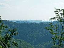
According to the U.S. Census Bureau, the county has a total area of 264 square miles (680 km2), of which 262 square miles (680 km2) is land and 2.2 square miles (5.7 km2) (0.8%) is water.[9]
The county's highest point is Stuffley Knob, with an elevation of 1,496 feet (456 m).[10] Its lowest point is the Levisa Fork on the Lawrence County border, with an elevation of about 550 feet (168 m).[11]
Adjacent counties
- Lawrence County (north)
- Martin County (east)
- Floyd County (south)
- Magoffin County (southwest)
- Morgan County (northwest)
Transportation
Major highways
Air
Big Sandy Regional Airport, located in adjacent Martin County, is the nearest airport. It is used as a general aviation airport.
The nearest airport that provides commercial aviation services is Tri-State Airport, which is located 55 miles (89 km) northeast in Ceredo, West Virginia.
Demographics
| Historical population | |||
|---|---|---|---|
| Census | Pop. | %± | |
| 1850 | 3,873 | — | |
| 1860 | 5,306 | 37.0% | |
| 1870 | 7,494 | 41.2% | |
| 1880 | 9,155 | 22.2% | |
| 1890 | 11,027 | 20.4% | |
| 1900 | 13,730 | 24.5% | |
| 1910 | 17,482 | 27.3% | |
| 1920 | 19,622 | 12.2% | |
| 1930 | 22,968 | 17.1% | |
| 1940 | 25,771 | 12.2% | |
| 1950 | 23,846 | −7.5% | |
| 1960 | 19,748 | −17.2% | |
| 1970 | 17,539 | −11.2% | |
| 1980 | 24,432 | 39.3% | |
| 1990 | 23,248 | −4.8% | |
| 2000 | 23,445 | 0.8% | |
| 2010 | 23,356 | −0.4% | |
| Est. 2015 | 23,175 | [12] | −0.8% |
| U.S. Decennial Census[13] 1790-1960[14] 1900-1990[15] 1990-2000[16] 2010-2013[1] | |||
As of the census[17] of 2000, there were 23,445 people, 9,103 households, and 6,863 families residing in the county. The population density was 90 per square mile (35/km2). There were 10,236 housing units at an average density of 39 per square mile (15/km2). The racial makeup of the county was 98.64% White, 0.25% Black or African American, 0.13% Native American, 0.29% Asian, 0.02% Pacific Islander, 0.09% from other races, and 0.58% from two or more races. 0.61% of the population were Hispanic or Latino of any race.
There were 9,103 households out of which 34.10% had children under the age of 18 living with them, 60.50% were married couples living together, 11.30% had a female householder with no husband present, and 24.60% were non-families. 22.30% of all households were made up of individuals and 9.00% had someone living alone who was 65 years of age or older. The average household size was 2.52 and the average family size was 2.93.
In the county the population was spread out with 24.00% under the age of 18, 8.80% from 18 to 24, 28.90% from 25 to 44, 25.70% from 45 to 64, and 12.60% who were 65 years of age or older. The median age was 37 years. For every 100 females there were 93.10 males. For every 100 females age 18 and over, there were 90.70 males.
The median income for a household in the county was $24,911, and the median income for a family was $29,142. Males had a median income of $29,762 versus $20,136 for females. The per capita income for the county was $14,051. About 21.70% of families and 26.60% of the population were below the poverty line, including 35.50% of those under age 18 and 19.30% of those age 65 or over.[18]
Politics
| Year | Republican | Democrat |
|---|---|---|
| 2016 | 84.03% 8,043 | 13.06% 1,250 |
| 2012 | 78.53% 7,095 | 19.07% 1,723 |
| 2008 | 69.84% 5,948 | 28.26% 2,407 |
| 2004 | 63.84% 5,940 | 35.34% 3,288 |
| 2000 | 58.47% 4,783 | 39.74% 3,251 |
Education
Public
Johnson County is home to two public school districts.
Johnson County Schools
The Johnson County School District, which operates schools throughout the county, including the city of Paintsville, operates the following schools:
Porter Elementary, W.R. Castle Elementary, Meade Memorial Elementary, Highland Elementary, Flat Gap Elementary, Central Elementary, Johnson County Middle School, and Johnson Central High School.
Central Elementary was ranked top-performing elementary school in 5-6 statewide CTBS/CATS testing. Central Elementary was also the top-performing elementary school (based on national CTBS testing) in the Southeastern US.
Johnson County Middle School's academic team has won the most State Governor's Cups. It has won the Cup in 1999, 2000, 2004, 2006, 2007, 2008, 2009, 2010, 2012, 2013, and 2014. It has won numerous state Quick Recall awards and its Future Problem Solving team has won state and international awards and acclaim.
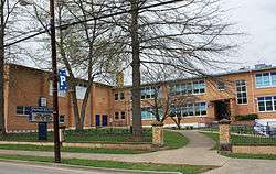
Johnson Central High School performs well in various areas and is well known statewide for their academic, football, and basketball teams. The high school was recently named a U.S. News & World Report Top American High School, being given a bronze award. Also, the school recently became WSAZ's first 'Cool School'. Johnson Central High school is considered a "powerhouse" in the high school Quick Recall scene, starting with the 1994-1995 season. They are also noted as a well-performing national quiz bowl competitor. Their football team, coached by Jim Matney, in recent years, has been noted for their up-and-coming program and very successful seasons. In fact, the 2006 Season was a record one, having a 13-1 record. The basketball team is coached by Tommy McKenzie and played in the Kentucky High School Athletic Association (KHSAA) State basketball tournament. Johnson Central offers many clubs including STLP, FBLA, DECA, Beta, FFA, HOSA, SkillsUSA and FCCLA. Johnson Central is also home to a new Career Technology Center.
Paintsville Independent Schools
The Paintsville Independent School District also operates two schools: Paintsville Elementary School, a K-6 facility, and the 7-12 Paintsville High School. Paintsville High also has earned numerous sport titles . The school has won boys' state championships in golf, baseball and basketball and made it to the finals of the state football playoffs. Note that in Kentucky, the only sports in which schools are divided into enrollment classes are football, cross-country and track.
Both the Johnson County and Paintsville Independent districts met all of the No Child Left Behind standards set by the national government.[20][21]
Private
Two private schools also operate in the county: Our Lady of the Mountain School (K-8) and Johnson County Christian School.
Colleges
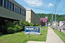
- Big Sandy Community and Technical College manages two campuses in Johnson County: Mayo and Hager Hill.
Attractions
Kentucky Apple Festival
In the same year as Mayo's death (1914), the first county fair was held in Paintsville, where the first Apple King was also crowned.
In 1962, Johnson County hosted the first Kentucky Apple Festival,[7] which has been held annually in Paintsville since. The streets of downtown Paintsville are closed to vehicular traffic and festivities to include live music and entertainment, along with various competitions.
Parks and recreation
- Paintsville Lake State Park
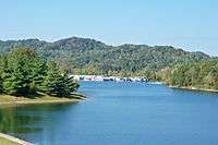
This scenic state park contains a 1,140 acres (4.6 km2) lake, a 12,404-acre (50.20 km2) wildlife management area, a marina, a 4 lane boat dock, a restaurant, a convenience store, boat rentals, multiple picnic shelters, playgrounds, and both developed and primitive camp sites. It is located on route 2275 at Staffordsville, just a few miles out of Paintsville.
- Paintsville Recreation Center
The Paintsville Recreation Center contains a basketball court, a playground, and a volleyball court. Located on Preston Street in Paintsville.
- Paintsville Country Club & Golf Course
This 18-hole golf course was established on September 27, 1929, making it one of the oldest golf courses in Eastern Kentucky.[22] The country club was built in 1930 by the WPA and is on the National Register of Historic Places.[23] Located on Kentucky Route 1107 in Paintsville.
Museums
- U.S. 23 Country Music Highway Museum
This museum has many exhibits that tell the stories of the country music stars that grew up near U.S. Route 23 in Eastern Kentucky. Located at 120 Staves Branch in Paintsville.
- The Coal Miners' Museum
This museum tells the history of the local area's coal mining industry. Located on Millers Creek Road in Van Lear.
Historical sites
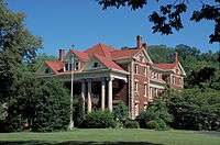
- Mayo Mansion
This 43-room mansion was built by John C. C. Mayo between 1905 and 1912 and now serves as Our Lady of the Mountains School. Located on Third Street in Paintsville.
- Mayo Memorial United Methodist Church
The church was also constructed by John C. C. Mayo, who hired 100 Masons from Italy to construct it. The church has an organ donated by Andrew Carnegie and has several large stain glass windows. The church opened in the fall of 1909. Located on Third Street in Paintsville, beside Mayo Mansion.
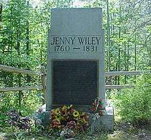
- Jenny Wiley Gravesite
Jenny Wiley is a historical figure who was captured by Native Americans in Virginia. After she escaped captivity, she reunited with her husband and lived in Johnson County until her death in 1831. Her grave is located just off Highway 581 at River.
Points of interest
- Loretta Lynn and Crystal Gayle Homeplace
Childhood home of country music superstars, Loretta Lynn and Crystal Gayle. Located at Butcher Hollow in Van Lear.
- Forrest and Maxie Preston Memorial Bridge
This 420-foot (130 m) pedestrian only swinging bridge is the world's longest plastic bridge. The deck of the bridge is made of glass fiber-reinforced polymer. It crosses the Levisa Fork of the Big Sandy River and connects the communities of River and Offutt. Located on Kentucky Route 581 at River.
- Mountain Homeplace
The Mountain Homeplace gives a unique look at a replica of an Eastern Kentucky farming community from the mid-nineteenth century. It contains a one-room schoolhouse, a church, a blacksmith shop, a cabin, a barn, and farm grounds. There are also demonstrations of old time skills and crafts. It is located near the dam at Paintsville Lake State Park.
Miscellaneous
Johnson County is also the former home of the Enterprise Association of Regular Baptists, which was organized on Friday, October 26, 1894 at Enterprise (now known as Redbush), Kentucky. The association now resides at 1560 Nibert Road, Gallipolis, Ohio, 45631.[24]
Communities
City
Unincorporated communities
- Asa
- Boonscamp
- Chandlerville
- Collista
- Denver
- Dobson
- East Point
- Elna
- Flat Gap
- Fuget
- Hager Hill
- Hargis
- Keaton
- Kerz
- Leander
- Low Gap
- Manila
- Meally
- Nero
- Nippa
- Odds
- Offutt
- Oil Springs
- Redbush
- River
- Riceville
- Sip
- Sitka
- Staffordsville
- Stambaugh
- Swamp Branch
- Thealka
- Thelma
- Tutor Key
- Van Lear
- Volga
- West Van Lear
- Whitehouse
- Williamsport
- Winifred
- Wittensville
Notable residents
- Loretta Lynn, country singer, raised here. The title song on her 2004 album, Van Lear Rose, references her upbringing in the city of Van Lear located in Johnson County.
- Crystal Gayle, country singer and younger sister of Loretta Lynn.
- Chris Stapleton, country musician
- Jenny Wiley, held captive by Native Americans.
- John C. C. Mayo, entrepreneur, assisted in bringing railroad service to eastern Kentucky.
- Jim Ford, singer-songwriter
- Hylo Brown, bluegrass and country music singer
- Johnnie LeMaster, former major league baseball player
- John Pelphrey, basketball standout for University of Kentucky, and Arkansas head basketball coach
- Charles Meade, leader of an isolationist end-of-times Christian church
- Willie Blair, former Major League Baseball player
See also
- Big Sandy Area Development District
- Citizens National Bank
- Johnson County Public Library
- National Register of Historic Places listings in Johnson County, Kentucky
- Paintsville-Prestonsburg Combs Field
- Paul B. Hall Regional Medical Center
- Francis M. Stafford House
References
- 1 2 "State & County QuickFacts". United States Census Bureau. Retrieved March 8, 2014.
- ↑ "Find a County". National Association of Counties. Retrieved 2011-06-07.
- ↑ The Register of the Kentucky State Historical Society, Volume 1. Kentucky State Historical Society. 1903. p. 35.
- ↑ Collins, Lewis (1877). History of Kentucky. p. 399.
- ↑ Johnson Country Historical and Genealogical Society (August 21, 2001). Johnson County, Kentucky: History and Families. Paducah, KY: Turner Publishing. p. 8. ISBN 978-1563117565. OCLC 57514858. OL 8642451M.
- ↑ Wells, J.K. (1992). The Gathering of the Trades People: The Early and Pre-History of Paintsville and Johnson County, Kentucky (Hardcover). pp. 98 pages. ASIN B0006EZ726.
- 1 2 3 4 Johnson County Historical Society. "Overview of Paintsville and Johnson County History". Retrieved 2007-06-05.
- ↑ Johnson County Historical Society. "John C. C. Mayo". Retrieved 2007-06-05.
- ↑ "2010 Census Gazetteer Files". United States Census Bureau. August 22, 2012. Retrieved August 16, 2014.
- ↑ U.S. Geological Survey Geographic Names Information System: Stuffley Knob Retrieved on 2010-1-7
- ↑ Topography of Johnson County, Kentucky Retrieved on 2010-1-7
- ↑ "County Totals Dataset: Population, Population Change and Estimated Components of Population Change: April 1, 2010 to July 1, 2015". Retrieved July 2, 2016.
- ↑ "U.S. Decennial Census". United States Census Bureau. Retrieved August 16, 2014.
- ↑ "Historical Census Browser". University of Virginia Library. Retrieved August 16, 2014.
- ↑ "Population of Counties by Decennial Census: 1900 to 1990". United States Census Bureau. Retrieved August 16, 2014.
- ↑ "Census 2000 PHC-T-4. Ranking Tables for Counties: 1990 and 2000" (PDF). United States Census Bureau. Retrieved August 16, 2014.
- ↑ "American FactFinder". United States Census Bureau. Retrieved 2008-01-31.
- ↑ US Census Bureau. "Johnson County QuickFacts from the US Census Bureau". Retrieved 2007-06-06.
- ↑ "Dave Leip's Atlas of U.S. Presidential Elections". Retrieved 2016-04-12.
- ↑ SchoolMatters (2006). "Paintsville High School, Kentucky Public School - Overview". Retrieved 2007-06-06.
- ↑ SchoolMatters (2006). "Johnson Central High School, Kentucky Public School - Overview". Retrieved 2007-06-06.
- ↑ Johnson County History:1900-1950 Retrieved on 2010-2-26
- ↑ Powell, Helen National Register of Historic Places Nomination Form for Paintsville Country Club 26 January 1989. Retrieved on 2010-2-26
- ↑ Enterprise Association of Regular Baptists Retrieved on 2010-2-27
External links
- WSIP radio
- WKLW radio
- Paintsville/Johnson County Chamber of Commerce
- Paintsville Tourism
- Johnson County Public Schools
- The Paintsville Herald
- History of Johnson County
- Kentucky Apple Festival
- Johnson County Public Library
- Paintsville Golf Course

Coordinates: 37°50′N 82°50′W / 37.84°N 82.83°W