Lawrence County, Kentucky
| Lawrence County, Kentucky | |
|---|---|
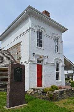
 Lawrence County Courthouse in Louisa | |
 Location in the U.S. state of Kentucky | |
 Kentucky's location in the U.S. | |
| Founded | December 14, 1821 |
| Named for | James Lawrence |
| Seat | Louisa |
| Largest city | Louisa |
| Area | |
| • Total | 420 sq mi (1,088 km2) |
| • Land | 416 sq mi (1,077 km2) |
| • Water | 4.5 sq mi (12 km2), 1.1% |
| Population | |
| • (2010) | 15,860 |
| • Density | 38/sq mi (15/km²) |
| Congressional district | 5th |
| Time zone | Eastern: UTC-5/-4 |
| Website |
www |
Lawrence County is a county located in the U.S. state of Kentucky. As of the 2010 census, the population was 15,860.[1] Its county seat is Louisa.[2] The county is named for James Lawrence,[3] and co-founded by Isaac Bolt, who served as a Lawrence County Commissioner and Justice of the Peace.
Lawrence County is the home of bluegrass music and country music star Ricky Skaggs. It is the birthplace of the late Chief Justice of the United States Frederick Moore Vinson and former Kentucky Governor Paul E. Patton. In regard to alcoholic beverage sales, Lawrence County is a wet county as of 2014, meaning the sale of alcoholic beverages is no longer prohibited everywhere in the county.
History
Lawrence County was established in 1821 from land given by Floyd and Greenup Counties.[4] Four courthouses have served Lawrence County; the first was completed in 1823.[5]
Geography
According to the U.S. Census Bureau, the county has a total area of 420 square miles (1,100 km2), of which 416 square miles (1,080 km2) is land and 4.5 square miles (12 km2) (1.1%) is water.[6]
The bridge from Louisa, in eastern Lawrence County, to Fort Gay, West Virginia is something of a geographic and architectural oddity. The quarter-mile concrete span spans across the Levisa Fork and the Tug River that come together and form the Big Sandy River, connects two states and has a right turn at its halfway point, which connects traffic to the Point Section neighborhood of Louisa.
Yatesville Lake State Park
Yatesville Lake was opened in 1992 and is a 2,300 acres (9.3 km2) reservoir managed by the Army Corps of Engineers. Yatesville Lake provides flood control for the region as well as recreational opportunities. The Corps manages a boat ramp at the Rich Creek area.
Adjacent counties
- Carter County (northwest)
- Boyd County (north)
- Wayne County, West Virginia (east)
- Martin County (southeast)
- Johnson County (south)
- Morgan County (southwest)
- Elliott County (west)
Demographics
| Historical population | |||
|---|---|---|---|
| Census | Pop. | %± | |
| 1830 | 3,900 | — | |
| 1840 | 4,730 | 21.3% | |
| 1850 | 6,281 | 32.8% | |
| 1860 | 7,601 | 21.0% | |
| 1870 | 8,497 | 11.8% | |
| 1880 | 13,262 | 56.1% | |
| 1890 | 17,702 | 33.5% | |
| 1900 | 19,612 | 10.8% | |
| 1910 | 20,067 | 2.3% | |
| 1920 | 17,643 | −12.1% | |
| 1930 | 16,713 | −5.3% | |
| 1940 | 17,275 | 3.4% | |
| 1950 | 14,418 | −16.5% | |
| 1960 | 12,134 | −15.8% | |
| 1970 | 10,726 | −11.6% | |
| 1980 | 14,121 | 31.7% | |
| 1990 | 13,998 | −0.9% | |
| 2000 | 15,569 | 11.2% | |
| 2010 | 15,860 | 1.9% | |
| Est. 2015 | 15,745 | [7] | −0.7% |
| U.S. Decennial Census[8] 1790-1960[9] 1900-1990[10] 1990-2000[11] 2010-2013[1] | |||
As of the census[12] of 2000, there were 15,569 people, 5,954 households, and 4,477 families residing in the county. The population density was 37 per square mile (14/km2). There were 7,040 housing units at an average density of 17 per square mile (6.6/km2). The racial makeup of the county was 98.93% White, 0.10% Black or African American, 0.28% Native American, 0.07% Asian, 0.01% Pacific Islander, 0.05% from other races, and 0.56% from two or more races. 0.41% of the population were Hispanic or Latino of any race.
There were 5,954 households out of which 35.00% had children under the age of 18 living with them, 61.30% were married couples living together, 10.50% had a female householder with no husband present, and 24.80% were non-families. 22.40% of all households were made up of individuals and 10.00% had someone living alone who was 65 years of age or older. The average household size was 2.59 and the average family size was 3.02.
In the county the population was spread out with 25.30% under the age of 18, 8.80% from 18 to 24, 28.70% from 25 to 44, 24.70% from 45 to 64, and 12.40% who were 65 years of age or older. The median age was 36 years. For every 100 females there were 97.30 males. For every 100 females age 18 and over, there were 93.00 males.
The median income for a household in the county was $21,610, and the median income for a family was $26,113. Males had a median income of $30,735 versus $19,174 for females. The per capita income for the county was $12,008. About 25.30% of families and 30.70% of the population were below the poverty line, including 40.00% of those under age 18 and 27.30% of those age 65 or over.
Politics
| Year | Republican | Democrat |
|---|---|---|
| 2016 | 79.71% 4,816 | 17.30% 1,045 |
| 2012 | 71.44% 3,995 | 27.18% 1,520 |
| 2008 | 62.01% 3,503 | 36.04% 2,036 |
| 2004 | 57.65% 3,755 | 41.53% 2,705 |
| 2000 | 55.94% 2,969 | 42.55% 2,258 |
Communities
See also
References
- 1 2 "State & County QuickFacts". United States Census Bureau. Retrieved March 6, 2014.
- ↑ "Find a County". National Association of Counties. Retrieved 2011-06-07.
- ↑ The Register of the Kentucky State Historical Society, Volume 1. Kentucky State Historical Society. 1903. p. 35.
- ↑ "Lawrence County". The Kentucky Encyclopedia. 2000. Retrieved August 22, 2014.
- ↑ Hogan, Roseann Reinemuth (1992). Kentucky Ancestry: A Guide to Genealogical and Historical Research. Ancestry Publishing. p. 268. Retrieved 26 July 2013.
- ↑ "2010 Census Gazetteer Files". United States Census Bureau. August 22, 2012. Retrieved August 17, 2014.
- ↑ "County Totals Dataset: Population, Population Change and Estimated Components of Population Change: April 1, 2010 to July 1, 2015". Retrieved July 2, 2016.
- ↑ "U.S. Decennial Census". United States Census Bureau. Retrieved August 17, 2014.
- ↑ "Historical Census Browser". University of Virginia Library. Retrieved August 17, 2014.
- ↑ "Population of Counties by Decennial Census: 1900 to 1990". United States Census Bureau. Retrieved August 17, 2014.
- ↑ "Census 2000 PHC-T-4. Ranking Tables for Counties: 1990 and 2000" (PDF). United States Census Bureau. Retrieved August 17, 2014.
- ↑ "American FactFinder". United States Census Bureau. Retrieved 2008-01-31.
- ↑ "Dave Leip's Atlas of U.S. Presidential Elections". Retrieved 2016-04-13.
External links
Municipalities and communities of Lawrence County, Kentucky, United States | ||
|---|---|---|
| Cities | | |
| Unincorporated communities | ||

Coordinates: 38°04′N 82°44′W / 38.06°N 82.73°W