Kenton County, Kentucky
| Kenton County, Kentucky | |
|---|---|
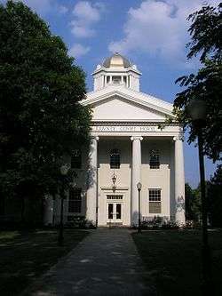 Kenton County Courthouse in Independence | |
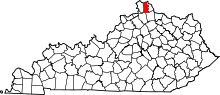 Location in the U.S. state of Kentucky | |
 Kentucky's location in the U.S. | |
| Founded | 1840 |
| Named for | Simon Kenton |
| Seat | Covington and Independence |
| Largest city | Covington |
| Area | |
| • Total | 164 sq mi (425 km2) |
| • Land | 160 sq mi (414 km2) |
| • Water | 4.1 sq mi (11 km2), 2.5% |
| Population | |
| • (2010) | 159,720 |
| • Density | 997/sq mi (385/km²) |
| Congressional district | 4th |
| Time zone | Eastern: UTC-5/-4 |
| Website |
www |
Kenton County is a county located in the Commonwealth of Kentucky. As of the 2010 census, the population was 159,720,[1] making it the third most populous county in Kentucky (behind Jefferson County and Fayette County). Its county seats are Covington and Independence.[2] It was, until November 24, 2010, the only county in Kentucky to have two legally recognized county seats. The county was formed in 1840 and is named for Simon Kenton, a frontiersman notable in the early history of the state.
Kenton County is included in the Cincinnati-Middletown, OH-KY-IN Metropolitan Statistical Area.
History
Kenton County was established on January 29, 1840, from land given by Campbell County. It was named in honor of Simon Kenton, a pioneer of Kentucky.[3][4]
Geography
According to the U.S. Census Bureau, the county has a total area of 164 square miles (420 km2), of which 160 square miles (410 km2) is land and 4.1 square miles (11 km2) (2.5%) is water.[5] The county is located at the confluence of the Licking River and Ohio River, in the outer Bluegrass area of the Bluegrass region of the state. The elevation in the country ranges from 455 feet (139 m) to 960 feet (293 m) above sea level.
Adjacent counties
- Hamilton County, Ohio (north)
- Campbell County (east)
- Pendleton County (southeast)
- Grant County (southwest)
- Boone County (west)
Demographics
| Historical population | |||
|---|---|---|---|
| Census | Pop. | %± | |
| 1850 | 17,038 | — | |
| 1860 | 25,467 | 49.5% | |
| 1870 | 36,096 | 41.7% | |
| 1880 | 43,983 | 21.9% | |
| 1890 | 54,161 | 23.1% | |
| 1900 | 63,591 | 17.4% | |
| 1910 | 70,355 | 10.6% | |
| 1920 | 73,453 | 4.4% | |
| 1930 | 93,534 | 27.3% | |
| 1940 | 93,139 | −0.4% | |
| 1950 | 104,254 | 11.9% | |
| 1960 | 120,700 | 15.8% | |
| 1970 | 129,440 | 7.2% | |
| 1980 | 137,058 | 5.9% | |
| 1990 | 142,031 | 3.6% | |
| 2000 | 151,464 | 6.6% | |
| 2010 | 159,720 | 5.5% | |
| Est. 2015 | 165,012 | [6] | 3.3% |
| U.S. Decennial Census[7] 1790-1960[8] 1900-1990[9] 1990-2000[10] 2010-2013[1] | |||
As of the census[11] of 2000, there were 151,464 people, 59,444 households, and 39,470 families living in the county. The population density was 935 per square mile (361/km2). There were 63,571 housing units at an average density of 392 per square mile (151/km2). The racial makeup of the county was 93.99% White, 3.84% Black or African American, 0.15% Native American, 0.59% Asian, 0.03% Pacific Islander, 0.41% from other races, and 1.00% from two or more races. 1.10% of the population were Hispanics or Latinos of any race.
There were 59,444 households out of which 33.40% had children under the age of 18 living with them, 50.10% were married couples living together, 12.10% had a female householder with no husband present, and 33.60% were non-families. 27.80% of all households were made up of individuals and 9.00% had someone living alone who was 65 years of age or older. The average household size was 2.52 and the average family size was 3.11.
The age distribution was 26.30% under 18, 9.20% from 18 to 24, 31.90% from 25 to 44, 21.40% from 45 to 64, and 11.10% who were 65 or older. The median age was 34 years. For every 100 females there were 96.20 males. For every 100 females age 18 and over, there were 91.90 males.
The median income for a household in the county was $43,906, and the median income for a family was $52,953. Males had a median income of $37,845 versus $27,253 for females. The per capita income for the county was $22,085. About 7.10% of families and 9.00% of the population were below the poverty line, including 12.00% of those under age 18 and 7.70% of those age 65 or over.
Education
Public schools

The public education in Kenton County is extensive, with five school districts providing education to those in all parts of Kenton County, including the extremely southern rural areas and the highly urbanized north. The districts are:
- The Kenton County School District
- Covington Independent Public Schools
- Beechwood Independent School District (serves Fort Mitchell)
- Ludlow Independent Schools
- Erlanger-Elsmere Schools
Private schools
The Catholic educational system is as extensive as the public system. These schools are operated by the Diocese of Covington's Department of Schools. The Diocese runs 17 schools in Kenton County.
Higher education
Thomas More College is the only institute of higher learning wholly in the county itself. Northern Kentucky University had a Covington campus located at 1401 Dixie Highway until it closed at the end of 2008. NKU's main campus is not far from Kenton County - only about 4 miles from the Licking River. The Kentucky Community and Technical College System also operates the Gateway Community and Technical College. Classes are provided at GCTC locations in Boone County, Covington, Park Hills and Edgewood.
Libraries
Kenton County is served by a county library with branches in Covington, Erlanger, and Independence. The Erlanger Branch has grown to be the busiest branch library in the state of Kentucky.[12]
In 2008, Kenton County Public Library received the highest score of any Kentucky library ranked by Hennen's American Public Library Ratings.[13]
Communities
Cities
Unincorporated communities
Visalia and Latonia Lakes have been dissolved as cities within Kenton County.
See also
References
- 1 2 "Kenton County QuickFacts from the US Census Bureau". Quickfacts.census.gov. Retrieved April 12, 2013.
- ↑ "Find a County". National Association of Counties. Retrieved 2011-06-07.
- ↑ The Register of the Kentucky State Historical Society, Volume 1. Kentucky State Historical Society. 1903. p. 35.
- ↑ Gannett, Henry (1905). The Origin of Certain Place Names in the United States. Govt. Print. Off. p. 173.
- ↑ "2010 Census Gazetteer Files". United States Census Bureau. August 22, 2012. Retrieved August 17, 2014.
- ↑ "County Totals Dataset: Population, Population Change and Estimated Components of Population Change: April 1, 2010 to July 1, 2015". Retrieved July 2, 2016.
- ↑ "U.S. Decennial Census". United States Census Bureau. Retrieved August 17, 2014.
- ↑ "Historical Census Browser". University of Virginia Library. Retrieved August 17, 2014.
- ↑ "Population of Counties by Decennial Census: 1900 to 1990". United States Census Bureau. Retrieved August 17, 2014.
- ↑ "Census 2000 PHC-T-4. Ranking Tables for Counties: 1990 and 2000" (PDF). United States Census Bureau. Retrieved August 17, 2014.
- ↑ "American FactFinder". United States Census Bureau. Retrieved 2008-01-31.
- ↑ "Kenton County Library website". February 25, 2010.
- ↑ Hennen Jr., Thomas J. (October 7, 2008). "Hennen's American Public Library Ratings: State HAPLR Scores: Kentucky". haplr-index.com.
External links
- Kenton County government
- Kenton County Public Library
- Historical Images and Texts from Kenton County
- School districts:
- The Kenton County School District
- Beechwood Independent School District
- Covington Independent Public Schools — Old site (full content), new site (under construction)
- Erlanger-Elsmere Schools
- Ludlow Independent Schools
Municipalities and communities of Kenton County, Kentucky, United States | ||
|---|---|---|
| Cities | | |
| Unincorporated communities | ||
| Footnotes | ‡This populated place also has portions in an adjacent county or counties. | |

Coordinates: 38°56′N 84°32′W / 38.93°N 84.54°W