Saint-Hilaire-de-Beauvoir
| Saint-Hilaire-de-Beauvoir | ||
|---|---|---|
|
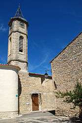
The church of Saint-Hilaire-de-Beauvoir | ||
| ||
 Saint-Hilaire-de-Beauvoir | ||
|
Location within Occitanie region  Saint-Hilaire-de-Beauvoir | ||
| Coordinates: 43°45′25″N 4°00′52″E / 43.7569°N 4.0144°ECoordinates: 43°45′25″N 4°00′52″E / 43.7569°N 4.0144°E | ||
| Country | France | |
| Region | Occitanie | |
| Department | Hérault | |
| Arrondissement | Montpellier | |
| Canton | Castries | |
| Intercommunality | Ceps et Sylves | |
| Government | ||
| • Mayor (2008–2014) | Marie-Claude Caizergues | |
| Area1 | 4.69 km2 (1.81 sq mi) | |
| Population (2008)2 | 351 | |
| • Density | 75/km2 (190/sq mi) | |
| Time zone | CET (UTC+1) | |
| • Summer (DST) | CEST (UTC+2) | |
| INSEE/Postal code | 34263 / 34160 | |
| Elevation |
39–86 m (128–282 ft) (avg. 80 m or 260 ft) | |
|
1 French Land Register data, which excludes lakes, ponds, glaciers > 1 km² (0.386 sq mi or 247 acres) and river estuaries. 2 Population without double counting: residents of multiple communes (e.g., students and military personnel) only counted once. | ||
.svg.png)
Saint-Hilaire-de-Beauvoir is a commune in the Hérault department in the Occitanie region in southern France.
Population
| Historical population | ||
|---|---|---|
| Year | Pop. | ±% |
| 1962 | 119 | — |
| 1968 | 136 | +14.3% |
| 1975 | 125 | −8.1% |
| 1982 | 131 | +4.8% |
| 1990 | 167 | +27.5% |
| 1999 | 273 | +63.5% |
| 2008 | 351 | +28.6% |
See also
References
| Wikimedia Commons has media related to Saint-Hilaire-de-Beauvoir. |
This article is issued from Wikipedia - version of the 11/12/2016. The text is available under the Creative Commons Attribution/Share Alike but additional terms may apply for the media files.