Saint-Jean-de-la-Blaquière
| Saint-Jean-de-la-Blaquière | ||
|---|---|---|
|
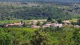
A general view of Saint-Jean-de-la-Blaquière | ||
| ||
 Saint-Jean-de-la-Blaquière | ||
|
Location within Occitanie region  Saint-Jean-de-la-Blaquière | ||
| Coordinates: 43°42′57″N 3°25′25″E / 43.7158°N 3.4236°ECoordinates: 43°42′57″N 3°25′25″E / 43.7158°N 3.4236°E | ||
| Country | France | |
| Region | Occitanie | |
| Department | Hérault | |
| Arrondissement | Lodève | |
| Canton | Lodève | |
| Intercommunality | Lodévois-Larzac | |
| Government | ||
| • Mayor (2008–2014) | Anne-Marie Fabre | |
| Area1 | 17.22 km2 (6.65 sq mi) | |
| Population (2008)2 | 516 | |
| • Density | 30/km2 (78/sq mi) | |
| Time zone | CET (UTC+1) | |
| • Summer (DST) | CEST (UTC+2) | |
| INSEE/Postal code | 34268 / 34700 | |
| Elevation |
85–557 m (279–1,827 ft) (avg. 115 m or 377 ft) | |
|
1 French Land Register data, which excludes lakes, ponds, glaciers > 1 km² (0.386 sq mi or 247 acres) and river estuaries. 2 Population without double counting: residents of multiple communes (e.g., students and military personnel) only counted once. | ||
.svg.png)
Saint-Jean-de-la-Blaquière is a commune in the Hérault department in the Occitanie region in southern France.
Population
| Historical population | ||
|---|---|---|
| Year | Pop. | ±% |
| 1962 | 270 | — |
| 1968 | 300 | +11.1% |
| 1975 | 259 | −13.7% |
| 1982 | 263 | +1.5% |
| 1990 | 338 | +28.5% |
| 1999 | 361 | +6.8% |
| 2008 | 516 | +42.9% |
See also
References
| Wikimedia Commons has media related to Saint-Jean-de-la-Blaquière. |
This article is issued from Wikipedia - version of the 11/12/2016. The text is available under the Creative Commons Attribution/Share Alike but additional terms may apply for the media files.