Villeneuve-lès-Béziers
| Villeneuve-lès-Béziers | ||
|---|---|---|
|
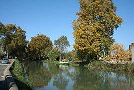
Canal du Midi | ||
| ||
 Villeneuve-lès-Béziers | ||
|
Location within Occitanie region  Villeneuve-lès-Béziers | ||
| Coordinates: 43°18′56″N 3°16′52″E / 43.3156°N 3.2811°ECoordinates: 43°18′56″N 3°16′52″E / 43.3156°N 3.2811°E | ||
| Country | France | |
| Region | Occitanie | |
| Department | Hérault | |
| Arrondissement | Béziers | |
| Canton | Béziers-2 | |
| Intercommunality | Béziers Méditerranée | |
| Government | ||
| • Mayor (2008–2014) | Jean Paul Galonnier | |
| Area1 | 17.31 km2 (6.68 sq mi) | |
| Population (2008)2 | 3,806 | |
| • Density | 220/km2 (570/sq mi) | |
| Time zone | CET (UTC+1) | |
| • Summer (DST) | CEST (UTC+2) | |
| INSEE/Postal code | 34336 / 34420 | |
| Elevation |
2–51 m (6.6–167.3 ft) (avg. 6 m or 20 ft) | |
|
1 French Land Register data, which excludes lakes, ponds, glaciers > 1 km² (0.386 sq mi or 247 acres) and river estuaries. 2 Population without double counting: residents of multiple communes (e.g., students and military personnel) only counted once. | ||
.svg.png)
Villeneuve-lès-Béziers is a commune in the Hérault department in the Occitanie region in southern France.
Population
| Historical population | ||
|---|---|---|
| Year | Pop. | ±% |
| 1962 | 2,135 | — |
| 1968 | 2,315 | +8.4% |
| 1975 | 2,502 | +8.1% |
| 1982 | 2,546 | +1.8% |
| 1990 | 2,972 | +16.7% |
| 1999 | 3,434 | +15.5% |
| 2008 | 3,806 | +10.8% |
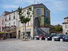
Street scene
See also
References
| Wikimedia Commons has media related to Villeneuve-lès-Béziers. |
This article is issued from Wikipedia - version of the 11/12/2016. The text is available under the Creative Commons Attribution/Share Alike but additional terms may apply for the media files.