Vic-la-Gardiole
| Vic-la-Gardiole | ||
|---|---|---|
|
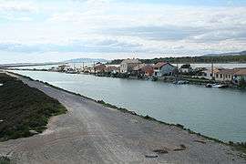
Canal du Rhône à Sète between two marshes at Les Aresquiers | ||
| ||
 Vic-la-Gardiole | ||
|
Location within Occitanie region  Vic-la-Gardiole | ||
| Coordinates: 43°29′27″N 3°47′51″E / 43.4908°N 3.7975°ECoordinates: 43°29′27″N 3°47′51″E / 43.4908°N 3.7975°E | ||
| Country | France | |
| Region | Occitanie | |
| Department | Hérault | |
| Arrondissement | Montpellier | |
| Canton | Frontignan | |
| Intercommunality | Bassin de Thau | |
| Government | ||
| • Mayor (2008–2014) | Jean-Pierre Deneu | |
| Area1 | 18.49 km2 (7.14 sq mi) | |
| Population (2008)2 | 2,820 | |
| • Density | 150/km2 (400/sq mi) | |
| Time zone | CET (UTC+1) | |
| • Summer (DST) | CEST (UTC+2) | |
| INSEE/Postal code | 34333 / 34110 | |
| Elevation |
0–216 m (0–709 ft) (avg. 10 m or 33 ft) | |
|
1 French Land Register data, which excludes lakes, ponds, glaciers > 1 km² (0.386 sq mi or 247 acres) and river estuaries. 2 Population without double counting: residents of multiple communes (e.g., students and military personnel) only counted once. | ||

Vic-la-Gardiole (Occitan: Vic la Gardiòla) is a commune in the Hérault department in the Occitanie region in southern France.
Population
| Historical population | ||
|---|---|---|
| Year | Pop. | ±% |
| 1962 | 541 | — |
| 1968 | 528 | −2.4% |
| 1975 | 602 | +14.0% |
| 1982 | 827 | +37.4% |
| 1990 | 1,607 | +94.3% |
| 1999 | 2,464 | +53.3% |
| 2008 | 2,820 | +14.4% |
Gallery
 "Bois des Aresquiers"
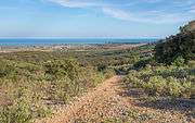 View from the Northwest
See also
References
| Wikimedia Commons has media related to Vic-la-Gardiole. |
This article is issued from Wikipedia - version of the 11/12/2016. The text is available under the Creative Commons Attribution/Share Alike but additional terms may apply for the media files.