Thézan-lès-Béziers
| Thézan-lès-Béziers | ||
|---|---|---|
|
The Montagne Noire and part of the commune of Thézan-lès-Béziers | ||
| ||
 Thézan-lès-Béziers | ||
|
Location within Occitanie region  Thézan-lès-Béziers | ||
| Coordinates: 43°25′21″N 3°10′14″E / 43.4225°N 3.1706°ECoordinates: 43°25′21″N 3°10′14″E / 43.4225°N 3.1706°E | ||
| Country | France | |
| Region | Occitanie | |
| Department | Hérault | |
| Arrondissement | Béziers | |
| Canton | Murviel-lès-Béziers | |
| Intercommunality | Orb et Taurou | |
| Government | ||
| • Mayor (2008–2014) | Alain Duro | |
| Area1 | 13.65 km2 (5.27 sq mi) | |
| Population (2008)2 | 2,547 | |
| • Density | 190/km2 (480/sq mi) | |
| Time zone | CET (UTC+1) | |
| • Summer (DST) | CEST (UTC+2) | |
| INSEE/Postal code | 34310 / 34490 | |
| Elevation |
15–132 m (49–433 ft) (avg. 63 m or 207 ft) | |
|
1 French Land Register data, which excludes lakes, ponds, glaciers > 1 km² (0.386 sq mi or 247 acres) and river estuaries. 2 Population without double counting: residents of multiple communes (e.g., students and military personnel) only counted once. | ||

.svg.png)
Thézan-lès-Béziers is a commune in the Hérault department in the Occitanie region in southern France.
Population
| Historical population | ||
|---|---|---|
| Year | Pop. | ±% |
| 1962 | 1,442 | — |
| 1968 | 1,499 | +4.0% |
| 1975 | 1,957 | +30.6% |
| 1982 | 2,016 | +3.0% |
| 1990 | 2,008 | −0.4% |
| 1999 | 2,076 | +3.4% |
| 2008 | 2,547 | +22.7% |
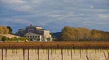
The winemaking cooperative.
See also
References
| Wikimedia Commons has media related to Thézan-lès-Béziers. |
This article is issued from Wikipedia - version of the 11/12/2016. The text is available under the Creative Commons Attribution/Share Alike but additional terms may apply for the media files.