Somwarpet
| Somwarpet ಸೋಮವಾರಪೇಟೆ | |
|---|---|
| Town | |
| Somawarapete | |
 Somwarpet Location of Somawarapete | |
| Coordinates: 12°36′N 75°52′E / 12.6°N 75.87°ECoordinates: 12°36′N 75°52′E / 12.6°N 75.87°E | |
| Country |
|
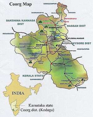
| State | Karnataka |
| District | Kodagu |
| Elevation | 1,027 m (3,369 ft) |
| Population (2011) | |
| • Total | 6,729 |
| Languages | |
| • Official | Kannada |
| • Other | Kannada, Arebhashe, Tulu, Kodava Takk |
| Time zone | IST (UTC+5:30) |
| ISO 3166 code | IN-KA |
| Vehicle registration | KA |
| Website |
www |
Somwarpet (somavārapēte, also written Somvarpet) is a panchayat town in Kodagu district in the Indian state of Karnataka. It is the main town of the Somwarpet taluk, in the north-east of the district.
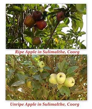
The main crops grown in the area are coffee and spice crops such as cardamom, peppers, oranges, ginger, and vegetables.
Demographics
As of the 2001 India census,[1] Somwarpet had a population of 7218. Males constitute 50% of the population and females 50%. Somvarpet has an average literacy rate of 75%, higher than the national average of 59.5%: male literacy is 80%, and female literacy is 70%. In Somvarpet, 12% of the population is under 6 years of age.
Languages
Even though most of the people living here are Kannadigas, other languages like Kodava Takk, Are Bhashe, Tulu, Beary bashe, Konkani, English and Hindi are spoken by the people.
Flora and fauna
Coffee is the major crop in the region. It is the major Arabica coffee growing region of India. Other crops like pepper, cardamom, orange, vanilla are grown. Rice is also grown.
Tourist attractions
_-_Copy.jpg)
Beelur Golf Club
Beelur Golf Club is located 8 km from Somwarpet town. The lush green golf ground attracts movie makers.
Malemalleshwara Betta Malemalleshwara Betta is located 13 km from Somwarpet and 7 km from Shanivarsanthe. Pooja is conducted regularly and a Grand Celebration on Maha Shiva Rathri every year.
Kotebetta Kotebetta [3] is the third highest peak in Coorg after Tadiyandamol and Brahmagiri, Kotebetta means "Fort Hill" because of its fort-like appearance. Its height above sea level is 1620 metres (5313 ft). It lies near the border between the Dakshina Kannada and Coorg districts. The trek starting point is a junction near a bridge called Hattihole. The peak is 10 km from Hattihole. There is a Shiva temple at the base of Kotebetta.
Makkalagudi Betta is located in Kiraganduru 10 km between Somwarpet and Madikeri road. There is a view of paddy fields, forest, and the waters of the Harangi reservoir.
Mallalli Falls (Kannada:ಮಲ್ಲಳ್ಳಿ ಜಲಪಾತ) Mallalli Abbi or Kumaradhara Falls is one of the tallest waterfalls in the Coorg where the river Kumaradhara drops down 200 feet. Scattered along the stream are other misty waterfalls, situated on the foothills of the Pushpagiri hill-ranges, 25 km from Somwarpet.
"Beauty Spot" in mathanahaill, somwarpet, saniversante road. " Mountain Mist coffee valley"
References
- ↑ "Census of India 2001: Data from the 2001 Census, including cities, villages and towns (Provisional)". Census Commission of India. Archived from the original on 2004-06-16. Retrieved 2008-11-01.
- ↑ "Portico of the Coorg Rajah's Palace at Somwaspett". The Wesleyan Juvenile Offering: A Miscellany of Missionary Information for Young Persons. Wesleyan Missionary Society. X: 48. May 1853. Retrieved 29 February 2016.
- ↑
External links
| Wikimedia Commons has media related to Somwarpet. |